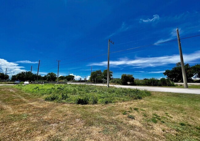
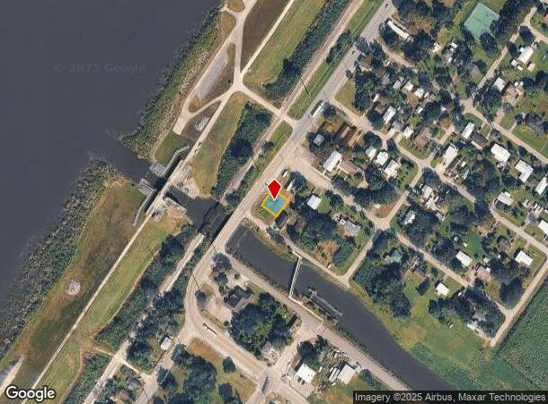
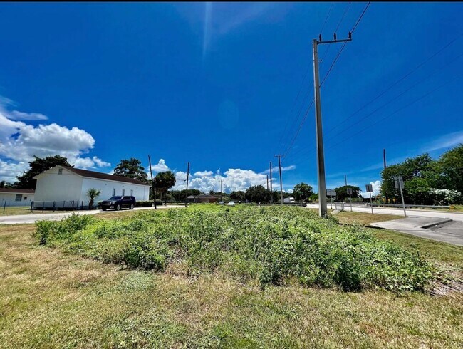
Property Record
12588 Us Highway 441, Canal Point, FL 33438
NEARBY LISTINGS FOR SALE OR LEASE
-
-
View all Canal Point listings for sale on LoopNet.com
Property Detail
12588 Us Highway 441
West Palm Beach-Boca Raton-Delray Beach, FL
Pioneer Inv Co Pl 1 Townsite
00-37-41-33-01-001-0030
PIONEER INV CO PL 1 TOWNSITE CNL POINT LTS 3 TO 5 INC BLK 1
Commercialacreage
Palm Beach
AO
Florida
12099C0257F
3-5
2024
0.13 AC
2025
Palm Bch Cty Outlying
008001
South Florida
DEMOGRAPHICS near 12588 Us Highway 441
1 Mile
3 Mile
5 Mile
2024 Total Population
638
1,886
7,435
2029 Population
658
1,944
7,662
Pop Growth 2024-2029
+ 3.13%
+ 3.08%
+ 3.05%
Average Age
39
39
36
2024 Total Households
162
488
2,325
HH Growth 2024-2029
+ 1.85%
+ 2.05%
+ 2.45%
Median Household Inc
$30,937
$27,272
$22,775
Avg Household Size
3.00
3.00
2.90
2024 Avg HH Vehicles
2.00
2.00
1.00
Median Home Value
$159,259
$162,179
$140,807
Median Year Built
1965
1966
1972
Nearby Places
Map Layers
Map Styles
 Street
 Aerial
- Restaurants
- Banks
- Shops
- Fitness
- Groceries
SALE & LEASE HISTORY
LISTING DATE
SALE/LEASE

Jan 17, 2023
For Sale
Nearby Properties
Address
Land Use
TOTAL SIZE
Lot Size
Zoning
Address
Land Use
TOTAL SIZE
Lot Size
Zoning
97,658 SF
19.97 AC
AP
Address
Land Use
TOTAL SIZE
Lot Size
Zoning
164,185 SF
33.70 AC
PF
Address
Land Use
TOTAL SIZE
Lot Size
Zoning
78,217 SF
16.09 AC
PO
Address
Land Use
TOTAL SIZE
Lot Size
Zoning
10,972 SF
549.28 AC
AP
Address
Land Use
TOTAL SIZE
Lot Size
Zoning
28,878 SF
2.47 AC
SFMU
Address
Land Use
TOTAL SIZE
Lot Size
Zoning
12,587 SF
15.02 AC
AG
Address
Land Use
TOTAL SIZE
Lot Size
Zoning
8,821 SF
2.68 AC
AG
Address
Land Use
TOTAL SIZE
Lot Size
Zoning
19,054 SF
2.86 AC
SFMU
Address
Land Use
TOTAL SIZE
Lot Size
Zoning
21,671 SF
1.85 AC
AP
Address
Land Use
TOTAL SIZE
Lot Size
Zoning
80,706 SF
551.07 AC
AP
Address
Land Use
TOTAL SIZE
Lot Size
Zoning
18,380 SF
2.60 AC
NC
Address
Land Use
TOTAL SIZE
Lot Size
Zoning
10,652 SF
0.85 AC
LI
Address
Land Use
TOTAL SIZE
Lot Size
Zoning
10,497 SF
0.99 AC
AG
Address
Land Use
TOTAL SIZE
Lot Size
Zoning
436.77 AC
AP
Address
Land Use
TOTAL SIZE
Lot Size
Zoning
3,420 SF
0.32 AC
LI
Address
Land Use
TOTAL SIZE
Lot Size
Zoning
47.03 AC
AP
Address
Land Use
TOTAL SIZE
Lot Size
Zoning
17,484 SF
1.32 AC
RH
Address
Land Use
TOTAL SIZE
Lot Size
Zoning
4,200 SF
1.22 AC
CG
Address
Land Use
TOTAL SIZE
Lot Size
Zoning
6,912 SF
0.95 AC
IL
Address
Land Use
TOTAL SIZE
Lot Size
Zoning
3,395 SF
0.87 AC
SFMU
Address
Land Use
TOTAL SIZE
Lot Size
Zoning
5,416 SF
1.04 AC
SF7
Address
Land Use
TOTAL SIZE
Lot Size
Zoning
3,132 SF
4.62 AC
HI
Address
Land Use
TOTAL SIZE
Lot Size
Zoning
3,480 SF
19.83 AC
AG
Address
Land Use
TOTAL SIZE
Lot Size
Zoning
4,817 SF
4.54 AC
AR
Address
Land Use
TOTAL SIZE
Lot Size
Zoning
7,823 SF
0.94 AC
LI
Address
Land Use
TOTAL SIZE
Lot Size
Zoning
21,340 SF
5.32 AC
HI
Address
Land Use
TOTAL SIZE
Lot Size
Zoning
5,068 SF
0.68 AC
IL
Address
Land Use
TOTAL SIZE
Lot Size
Zoning
11,930 SF
1.31 AC
AG
Address
Land Use
TOTAL SIZE
Lot Size
Zoning
3,977 SF
1.31 AC
SF5
Address
Land Use
TOTAL SIZE
Lot Size
Zoning
21.96 AC
AP
The World's #1 Commercial Real Estate Marketplace
Connect with us
© 2025 CoStar Group
The information above has been obtained from sources believed reliable. While we do not doubt its accuracy we have not verified it and make no guarantee, warranty or representation about it. It is your responsibility to independently confirm its accuracy and completeness. Any projections, opinions, assumptions, or estimates used are for example only and do not represent the current or future performance of the property. The value of this transaction to you depends on tax and other factors which should be evaluated by your tax, financial, and legal advisors. You and your advisors should conduct a careful, independent investigation of the property to determine to your satisfaction the suitability of the property for your needs.