Property Record
1259 Piney Forest Rd, Danville, VA 24540

Property Detail
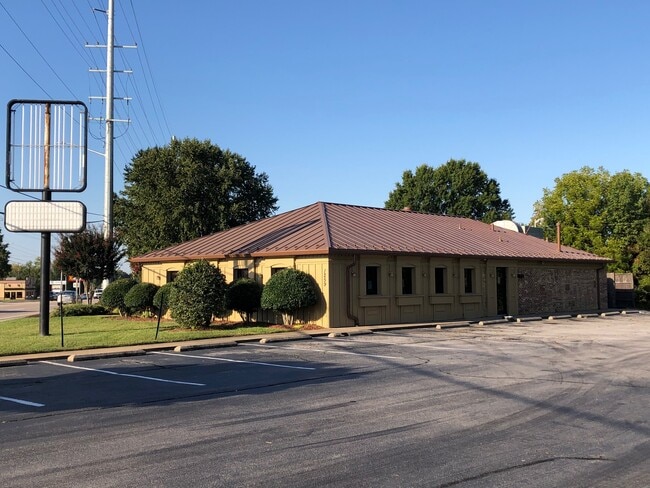
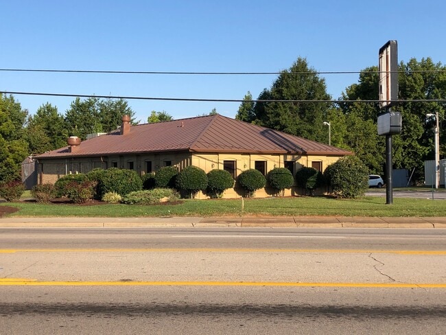
1259 Piney Forest Rd
58850
161.05 FT PINEY FOREST RD
Restaurantbuilding
Danville City
HIGHWAY RE
Virginia
B and X Area of moderate flood hazard, usually the area between the limits of the 100-year and 500-year floods.
0.59 AC
2025
Virginia South Central
2025
Other Market Areas
000200
Danville, VA
2,520 SF
NEARBY LISTINGS FOR SALE OR LEASE
DEMOGRAPHICS near 1259 Piney Forest Rd
1 mile
3 mile
5 mile
2025 Total Population
5,797
24,564
48,040
2030 Population
5,573
24,308
47,633
Pop Growth 2025-2030
(3.86%)
(1.04%)
(0.85%)
Average Age
42
42
43
2025 Total Households
2,633
10,639
21,020
HH Growth 2025-2030
(3.91%)
(1.13%)
(0.84%)
Median Household Inc
$44,851
$44,293
$46,212
Avg Household Size
2.20
2.20
2.20
2025 Avg HH Vehicles
2.00
2.00
2.00
Median Home Value
$131,596
$124,034
$148,114
Median Year Built
1969
1966
1966
Nearby Places
Map Layers
Map Styles
 Street
 Aerial
Layers
 Traffic
 Biking
Places
Listings with unknown addresses are not visible on the map
- Restaurants
- Banks
- Shops
- Fitness
- Groceries
PUBLIC TRANSPORTATION
COMMUTER RAIL
Drive
Walk
Distance
9 min
4.7 mi
SALE & LEASE HISTORY
LISTING DATE
SALE/LEASE

Oct 06, 2021
For Sale
Nov 11, 2022
For Lease
Nearby Properties
Address
Land Use
TOTAL SIZE
Lot Size
Zoning
Address
Land Use
TOTAL SIZE
Lot Size
Zoning
12.20 AC
B-2
Address
Land Use
TOTAL SIZE
Lot Size
Zoning
508,832 SF
10.86 AC
TOBACCO WA
Address
Land Use
TOTAL SIZE
Lot Size
Zoning
93,230 SF
40.74 AC
TRANSITION
Address
Land Use
TOTAL SIZE
Lot Size
Zoning
54,169 SF
3.44 AC
CENTRAL BU
Address
Land Use
TOTAL SIZE
Lot Size
Zoning
77,952 SF
16.59 AC
TRANSITION
Address
Land Use
TOTAL SIZE
Lot Size
Zoning
48,285 SF
3.76 AC
TOBACCO WA
Address
Land Use
TOTAL SIZE
Lot Size
Zoning
159,055 SF
31.73 AC
OVERLAY PL
Address
Land Use
TOTAL SIZE
Lot Size
Zoning
225,611 SF
19.53 AC
PLANNED SH
Address
Land Use
TOTAL SIZE
Lot Size
Zoning
1,000 SF
26.56 AC
TRANSITION
Address
Land Use
TOTAL SIZE
Lot Size
Zoning
2,516 SF
19.75 AC
DZ
Address
Land Use
TOTAL SIZE
Lot Size
Zoning
160,199 SF
15.90 AC
PLANNED SH
Address
Land Use
TOTAL SIZE
Lot Size
Zoning
59,791 SF
11.18 AC
HIGHWAY RE
Address
Land Use
TOTAL SIZE
Lot Size
Zoning
55,006 SF
4.49 AC
HIGHWAY RE
Address
Land Use
TOTAL SIZE
Lot Size
Zoning
625,362 SF
34.04 AC
PLANNED SH
Address
Land Use
TOTAL SIZE
Lot Size
Zoning
106,836 SF
11.67 AC
OVERLAY PL
Address
Land Use
TOTAL SIZE
Lot Size
Zoning
380,043 SF
9.40 AC
OVERLAY PL
Address
Land Use
TOTAL SIZE
Lot Size
Zoning
25.05 AC
M-2
Address
Land Use
TOTAL SIZE
Lot Size
Zoning
75,341 SF
3.20 AC
HIGHWAY RE
Address
Land Use
TOTAL SIZE
Lot Size
Zoning
37,213 SF
0.35 AC
CENTRAL BU
Address
Land Use
TOTAL SIZE
Lot Size
Zoning
61,546 SF
4.98 AC
HIGHWAY RE
Address
Land Use
TOTAL SIZE
Lot Size
Zoning
60,590 SF
5.30 AC
OLD TOWN R
Address
Land Use
TOTAL SIZE
Lot Size
Zoning
97,974 SF
12.22 AC
PLANNED SH
Address
Land Use
TOTAL SIZE
Lot Size
Zoning
58,540 SF
11.50 AC
TRANSITION
Address
Land Use
TOTAL SIZE
Lot Size
Zoning
104,827 SF
14.25 AC
PLANNED SH
Address
Land Use
TOTAL SIZE
Lot Size
Zoning
76,622 SF
10.21 AC
PLANNED SH
Address
Land Use
TOTAL SIZE
Lot Size
Zoning
96,366 SF
0.85 AC
TOBACCO WA
Address
Land Use
TOTAL SIZE
Lot Size
Zoning
43,349 SF
13 AC
TRANSITION
Address
Land Use
TOTAL SIZE
Lot Size
Zoning
34,016 SF
6.50 AC
HIGHWAY RE
Address
Land Use
TOTAL SIZE
Lot Size
Zoning
504 SF
8.33 AC
TRANSITION
Address
Land Use
TOTAL SIZE
Lot Size
Zoning
42,060 SF
3.10 AC
TRANSITION
The World's #1 Commercial Real Estate Marketplace
Connect with us
© 2026 CoStar Group
The information above has been obtained from sources believed reliable. While we do not doubt its accuracy we have not verified it and make no guarantee, warranty or representation about it. It is your responsibility to independently confirm its accuracy and completeness. Any projections, opinions, assumptions, or estimates used are for example only and do not represent the current or future performance of the property. The value of this transaction to you depends on tax and other factors which should be evaluated by your tax, financial, and legal advisors. You and your advisors should conduct a careful, independent investigation of the property to determine to your satisfaction the suitability of the property for your needs.