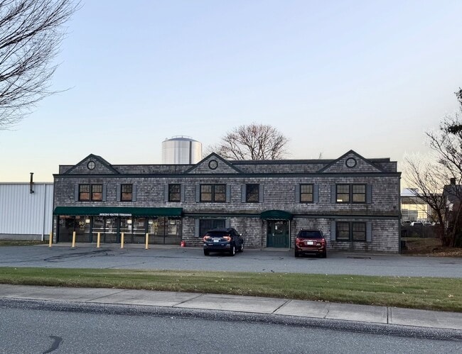
Property Record
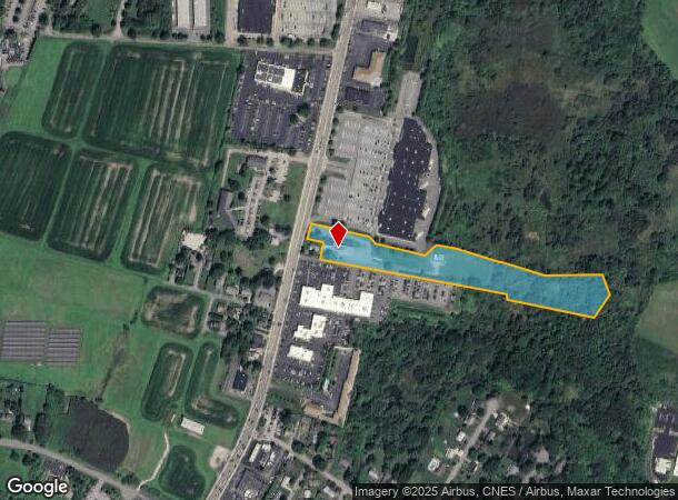
1259 W Main Rd, Middletown, RI 02842
Current Lease Availabilities
NEARBY LISTINGS FOR SALE OR LEASE
Property Detail
1259 W Main Rd
MIDD-000106-000000-000085
Newport
Commercialbuilding
Rhode Island
X
85
44005C0091J
5.75 AC
2025
Newport County
2025
Providence
040304
Providence-Warwick, RI-MA
12,520 SF
DEMOGRAPHICS near 1259 W Main Rd
1 Mile
3 Mile
5 Mile
2024 Total Population
5,773
30,064
54,172
2029 Population
5,503
29,007
53,180
Pop Growth 2024-2029
(4.68%)
(3.52%)
(1.83%)
Average Age
41
43
44
2024 Total Households
2,365
12,405
22,904
HH Growth 2024-2029
(5.20%)
(3.91%)
(2.00%)
Median Household Inc
$74,412
$82,691
$90,213
Avg Household Size
2.30
2.30
2.20
2024 Avg HH Vehicles
2.00
2.00
2.00
Median Home Value
$449,110
$486,768
$615,275
Median Year Built
1972
1962
1961
Nearby Places
Map Layers
Map Styles
 Street
 Aerial
- Restaurants
- Banks
- Shops
- Fitness
- Groceries
PUBLIC TRANSPORTATION
AIRPORT
Rhode Island Tf Green International
DRIVE
WALK
Distance
Rhode Island Tf Green International
49 min
30.4 mi
Freight Ports
Port of Davisville, RI
DRIVE
WALK
Distance
Port of Davisville, RI
35 min
19.1 mi
Nearby Properties
Address
Land Use
TOTAL SIZE
Lot Size
Zoning
Address
Land Use
TOTAL SIZE
Lot Size
Zoning
60.03 AC
R40
Address
Land Use
TOTAL SIZE
Lot Size
Zoning
104.20 AC
P
Address
Land Use
TOTAL SIZE
Lot Size
Zoning
249,902 SF
27.88 AC
UV
Address
Land Use
TOTAL SIZE
Lot Size
Zoning
24.70 AC
RMA
Address
Land Use
TOTAL SIZE
Lot Size
Zoning
86,091 SF
6.50 AC
CI
Address
Land Use
TOTAL SIZE
Lot Size
Zoning
120.20 AC
HI
Address
Land Use
TOTAL SIZE
Lot Size
Zoning
157,806 SF
36.80 AC
R30
Address
Land Use
TOTAL SIZE
Lot Size
Zoning
82.64 AC
Address
Land Use
TOTAL SIZE
Lot Size
Zoning
217,212 SF
10.46 AC
R10
Address
Land Use
TOTAL SIZE
Lot Size
Zoning
33 AC
PA
Address
Land Use
TOTAL SIZE
Lot Size
Zoning
172,320 SF
10.14 AC
R10
Address
Land Use
TOTAL SIZE
Lot Size
Zoning
17.92 AC
RMA
Address
Land Use
TOTAL SIZE
Lot Size
Zoning
108,365 SF
5.15 AC
R10
Address
Land Use
TOTAL SIZE
Lot Size
Zoning
36,984 SF
10 AC
R10
Address
Land Use
TOTAL SIZE
Lot Size
Zoning
Address
Land Use
TOTAL SIZE
Lot Size
Zoning
151,202 SF
15.98 AC
PA
Address
Land Use
TOTAL SIZE
Lot Size
Zoning
12.18 AC
GBA
Address
Land Use
TOTAL SIZE
Lot Size
Zoning
130,460 SF
10.15 AC
OP
Address
Land Use
TOTAL SIZE
Lot Size
Zoning
26.66 AC
R20
Address
Land Use
TOTAL SIZE
Lot Size
Zoning
2,713 SF
36.08 AC
OS
Address
Land Use
TOTAL SIZE
Lot Size
Zoning
14.90 AC
Address
Land Use
TOTAL SIZE
Lot Size
Zoning
209.80 AC
Address
Land Use
TOTAL SIZE
Lot Size
Zoning
99,369 SF
15.88 AC
GBA
Address
Land Use
TOTAL SIZE
Lot Size
Zoning
65,600 SF
5.03 AC
GB
Address
Land Use
TOTAL SIZE
Lot Size
Zoning
7.65 AC
GBA
Address
Land Use
TOTAL SIZE
Lot Size
Zoning
53,770 SF
8.82 AC
GBA
Address
Land Use
TOTAL SIZE
Lot Size
Zoning
100,503 SF
2.87 AC
UV
Address
Land Use
TOTAL SIZE
Lot Size
Zoning
103,824 SF
6.97 AC
OB
Address
Land Use
TOTAL SIZE
Lot Size
Zoning
27,301 SF
0.54 AC
LB
Address
Land Use
TOTAL SIZE
Lot Size
Zoning
7.88 AC
RM
The World's #1 Commercial Real Estate Marketplace
Connect with us
© 2026 CoStar Group
The information above has been obtained from sources believed reliable. While we do not doubt its accuracy we have not verified it and make no guarantee, warranty or representation about it. It is your responsibility to independently confirm its accuracy and completeness. Any projections, opinions, assumptions, or estimates used are for example only and do not represent the current or future performance of the property. The value of this transaction to you depends on tax and other factors which should be evaluated by your tax, financial, and legal advisors. You and your advisors should conduct a careful, independent investigation of the property to determine to your satisfaction the suitability of the property for your needs.