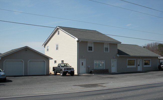
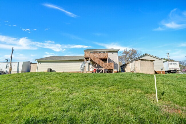
Property Record
12595 Hardy Rd, Hardy, VA 24101

Save to a Folder
{{folder.Name}}
{{folder.ListingIds.length}} Properties
{{folder.ListingIds.length}} Property
Create a New Folder
Property Detail
12595 Hardy Rd
173-A-128
HARDY
Commercialnec
Bedford
R1
Virginia
B and X Area of moderate flood hazard, usually the area between the limits of the 100-year and 500-year floods.
0.98 AC
2026
Lynchburg
2026
Other Market Areas
030602
Lynchburg, VA
3,680 SF
NEARBY LISTINGS FOR SALE OR LEASE
-
-
View all Hardy listings for sale on LoopNet.com
DEMOGRAPHICS near 12595 Hardy Rd
1 mile
3 mile
5 mile
2025 Total Population
894
4,534
20,877
2030 Population
907
4,621
21,145
Pop Growth 2025-2030
+ 1.45%
+ 1.92%
+ 1.28%
Average Age
45
46
44
2025 Total Households
369
1,905
8,648
HH Growth 2025-2030
+ 1.36%
+ 1.84%
+ 1.20%
Median Household Inc
$93,749
$86,280
$72,448
Avg Household Size
2.40
2.30
2.40
2025 Avg HH Vehicles
2.00
2.00
2.00
Median Home Value
$243,333
$234,638
$240,008
Median Year Built
1988
1979
1976
Nearby Places
Map Layers
Map Styles
 Street
 Aerial
Layers
 Traffic
 Biking
Places
Listings with unknown addresses are not visible on the map
- Restaurants
- Banks
- Shops
- Fitness
- Groceries
PUBLIC TRANSPORTATION
COMMUTER RAIL
Drive
Walk
Distance
20 min
9.0 mi
AIRPORT
Roanoke/Blacksburg Regional (Woodrum Field)
Drive
Walk
Distance
Roanoke/Blacksburg Regional (Woodrum Field)
29 min
13.1 mi
Lynchburg Regional/Preston Glenn Field
Drive
Walk
Distance
Lynchburg Regional/Preston Glenn Field
74 min
47.0 mi
SALE & LEASE HISTORY
LISTING DATE
SALE/LEASE

Jun 25, 2021
For Sale
Nearby Properties
Address
Land Use
TOTAL SIZE
Lot Size
Zoning
Address
Land Use
TOTAL SIZE
Lot Size
Zoning
Address
Land Use
TOTAL SIZE
Lot Size
Zoning
Address
Land Use
TOTAL SIZE
Lot Size
Zoning
8,564 SF
Address
Land Use
TOTAL SIZE
Lot Size
Zoning
8,564 SF
Address
Land Use
TOTAL SIZE
Lot Size
Zoning
17.30 AC
R1
Address
Land Use
TOTAL SIZE
Lot Size
Zoning
120 AC
A1
Address
Land Use
TOTAL SIZE
Lot Size
Zoning
116.70 AC
RPD
Address
Land Use
TOTAL SIZE
Lot Size
Zoning
122.08 AC
A1
Address
Land Use
TOTAL SIZE
Lot Size
Zoning
24.46 AC
R1
Address
Land Use
TOTAL SIZE
Lot Size
Zoning
258.07 AC
AG1
Address
Land Use
TOTAL SIZE
Lot Size
Zoning
3,200 SF
Address
Land Use
TOTAL SIZE
Lot Size
Zoning
3,200 SF
Address
Land Use
TOTAL SIZE
Lot Size
Zoning
7,276 SF
1.48 AC
R1
Address
Land Use
TOTAL SIZE
Lot Size
Zoning
6,082 SF
Address
Land Use
TOTAL SIZE
Lot Size
Zoning
6,082 SF
Address
Land Use
TOTAL SIZE
Lot Size
Zoning
66.80 AC
Address
Land Use
TOTAL SIZE
Lot Size
Zoning
3,892 SF
Address
Land Use
TOTAL SIZE
Lot Size
Zoning
8,104 SF
1 AC
A1
Address
Land Use
TOTAL SIZE
Lot Size
Zoning
5,557 SF
Address
Land Use
TOTAL SIZE
Lot Size
Zoning
4.37 AC
R1
Address
Land Use
TOTAL SIZE
Lot Size
Zoning
2,290 SF
19.27 AC
B2
Address
Land Use
TOTAL SIZE
Lot Size
Zoning
3,537 SF
Address
Land Use
TOTAL SIZE
Lot Size
Zoning
3,537 SF
Address
Land Use
TOTAL SIZE
Lot Size
Zoning
86.52 AC
R1
Address
Land Use
TOTAL SIZE
Lot Size
Zoning
5,871 SF
1.76 AC
A1
Address
Land Use
TOTAL SIZE
Lot Size
Zoning
5.97 AC
R1
Address
Land Use
TOTAL SIZE
Lot Size
Zoning
8.18 AC
R1
Address
Land Use
TOTAL SIZE
Lot Size
Zoning
2,952 SF
Address
Land Use
TOTAL SIZE
Lot Size
Zoning
2,952 SF
Address
Land Use
TOTAL SIZE
Lot Size
Zoning
5,000 SF
1 AC
R1
The World's #1 Commercial Real Estate Marketplace
Connect with us
© 2026 CoStar Group
The information above has been obtained from sources believed reliable. While we do not doubt its accuracy we have not verified it and make no guarantee, warranty or representation about it. It is your responsibility to independently confirm its accuracy and completeness. Any projections, opinions, assumptions, or estimates used are for example only and do not represent the current or future performance of the property. The value of this transaction to you depends on tax and other factors which should be evaluated by your tax, financial, and legal advisors. You and your advisors should conduct a careful, independent investigation of the property to determine to your satisfaction the suitability of the property for your needs.