Property Record
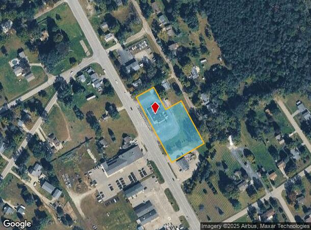
12598 N Saginaw Rd, Clio, MI 48420
NEARBY LISTINGS FOR SALE OR LEASE
Property Detail
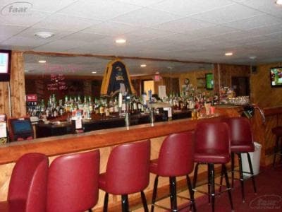
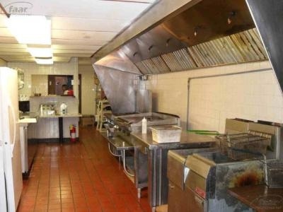
12598 N Saginaw Rd
Flint, MI
Village Of Farrandville
18-14-504-005
PART OF BLOCK 9 & PART OF SEC 11 & 14 BEG 20 FT S OF NE COR OF LOT 3 BLK 9 TH S 28 DEG 33 MIN E 270 FT TH S 60 DEG 12 MIN W
Commercialnec
Genesee
X
Michigan
26145C0550E
3
2024
1.70 AC
2025
Flint
010112
Detroit
5,621 SF
DEMOGRAPHICS near 12598 N Saginaw Rd
1 Mile
3 Mile
5 Mile
2024 Total Population
2,391
13,063
24,667
2029 Population
2,326
12,696
24,055
Pop Growth 2024-2029
(2.72%)
(2.81%)
(2.48%)
Average Age
42
44
43
2024 Total Households
954
5,448
10,093
HH Growth 2024-2029
(2.83%)
(2.88%)
(2.51%)
Median Household Inc
$53,111
$54,787
$56,989
Avg Household Size
2.40
2.30
2.40
2024 Avg HH Vehicles
2.00
2.00
2.00
Median Home Value
$145,275
$157,906
$158,540
Median Year Built
1959
1971
1971
Nearby Places
Map Layers
Map Styles
 Street
 Aerial
- Restaurants
- Banks
- Shops
- Fitness
- Groceries
PUBLIC TRANSPORTATION
AIRPORT
Bishop International
DRIVE
WALK
Distance
Bishop International
38 min
22.5 mi
MBS International
DRIVE
WALK
Distance
MBS International
55 min
37.0 mi
Freight Ports
Port of Toledo
DRIVE
WALK
Distance
Port of Toledo
151 min
128.6 mi
Nearby Properties
Address
Land Use
TOTAL SIZE
Lot Size
Zoning
Address
Land Use
TOTAL SIZE
Lot Size
Zoning
222,898 SF
25.88 AC
PUD
Address
Land Use
TOTAL SIZE
Lot Size
Zoning
218,537 SF
21.55 AC
PUD
Address
Land Use
TOTAL SIZE
Lot Size
Zoning
112,217 SF
10 AC
RM
Address
Land Use
TOTAL SIZE
Lot Size
Zoning
131,460 SF
8.10 AC
R-4
Address
Land Use
TOTAL SIZE
Lot Size
Zoning
47,105 SF
4.67 AC
RU-1
Address
Land Use
TOTAL SIZE
Lot Size
Zoning
167,731 SF
17.45 AC
C-3
Address
Land Use
TOTAL SIZE
Lot Size
Zoning
76,074 SF
7.73 AC
RM
Address
Land Use
TOTAL SIZE
Lot Size
Zoning
RU-1-RE
Address
Land Use
TOTAL SIZE
Lot Size
Zoning
RU-1-RE
Address
Land Use
TOTAL SIZE
Lot Size
Zoning
38,248 SF
25.95 AC
C-4
Address
Land Use
TOTAL SIZE
Lot Size
Zoning
63,888 SF
7 AC
RM
Address
Land Use
TOTAL SIZE
Lot Size
Zoning
59,680 SF
7.63 AC
RM
Address
Land Use
TOTAL SIZE
Lot Size
Zoning
43,580 SF
19.21 AC
C-4
Address
Land Use
TOTAL SIZE
Lot Size
Zoning
51,972 SF
8.32 AC
C-4
Address
Land Use
TOTAL SIZE
Lot Size
Zoning
5,242 SF
70.28 AC
MHP
Address
Land Use
TOTAL SIZE
Lot Size
Zoning
100,054 SF
12.68 AC
C-4
Address
Land Use
TOTAL SIZE
Lot Size
Zoning
56,588 SF
5.79 AC
C-4
Address
Land Use
TOTAL SIZE
Lot Size
Zoning
20,220 SF
4.82 AC
C-4
Address
Land Use
TOTAL SIZE
Lot Size
Zoning
864 SF
3.18 AC
R-4
Address
Land Use
TOTAL SIZE
Lot Size
Zoning
44,350 SF
3.82 AC
GC
Address
Land Use
TOTAL SIZE
Lot Size
Zoning
35.31 AC
MH
Address
Land Use
TOTAL SIZE
Lot Size
Zoning
34,856 SF
2.39 AC
RM
Address
Land Use
TOTAL SIZE
Lot Size
Zoning
18,843 SF
65.42 AC
AR
Address
Land Use
TOTAL SIZE
Lot Size
Zoning
8,264 SF
6.56 AC
C-4
Address
Land Use
TOTAL SIZE
Lot Size
Zoning
22,719 SF
5 AC
C-2
Address
Land Use
TOTAL SIZE
Lot Size
Zoning
19,323 SF
2.20 AC
C-4
Address
Land Use
TOTAL SIZE
Lot Size
Zoning
28,800 SF
4.15 AC
C-3
Address
Land Use
TOTAL SIZE
Lot Size
Zoning
13,219 SF
6.67 AC
C-3
Address
Land Use
TOTAL SIZE
Lot Size
Zoning
15,000 SF
2.22 AC
PUD
Address
Land Use
TOTAL SIZE
Lot Size
Zoning
39,404 SF
4.47 AC
R-4
The World's #1 Commercial Real Estate Marketplace
Connect with us
© 2025 CoStar Group
The information above has been obtained from sources believed reliable. While we do not doubt its accuracy we have not verified it and make no guarantee, warranty or representation about it. It is your responsibility to independently confirm its accuracy and completeness. Any projections, opinions, assumptions, or estimates used are for example only and do not represent the current or future performance of the property. The value of this transaction to you depends on tax and other factors which should be evaluated by your tax, financial, and legal advisors. You and your advisors should conduct a careful, independent investigation of the property to determine to your satisfaction the suitability of the property for your needs.