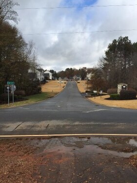
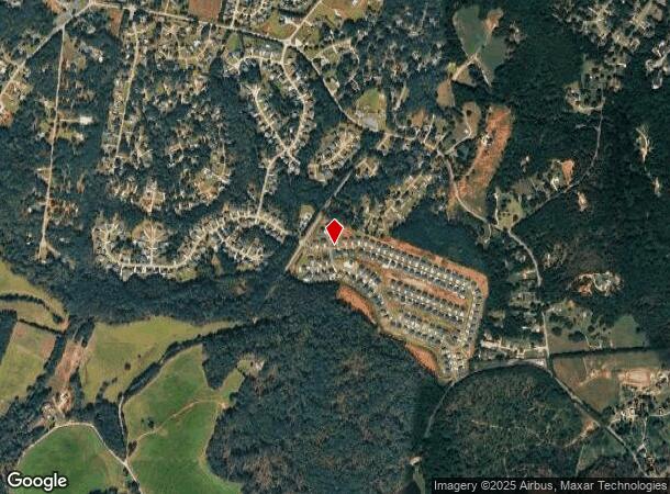
Property Record
126 Juniper Hill Dr, Easley, SC 29642
NEARBY LISTINGS FOR SALE OR LEASE
Property Detail
126 Juniper Hill Dr
Greenville-Anderson-Greer, SC
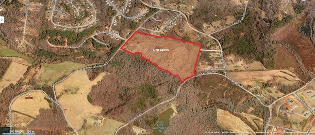
Survey For Thomas A Wigington Jr
188-00-08-014
CP S 000/000 PP S 1663/10 F000 D000 PP S 1644/1+2 OLD MILL RD 13.59 AC
Agriculturalland
Anderson
AE
South Carolina
45007C0043E
13.59 AC
2024
Powdersville/Easley
2023
Greenville/Spartanburg
010107
DEMOGRAPHICS near 126 Juniper Hill Dr
1 Mile
3 Mile
5 Mile
2024 Total Population
2,595
21,146
54,614
2029 Population
2,747
22,237
57,612
Pop Growth 2024-2029
+ 5.86%
+ 5.16%
+ 5.49%
Average Age
39
41
40
2024 Total Households
923
7,752
21,063
HH Growth 2024-2029
+ 5.85%
+ 5.16%
+ 5.49%
Median Household Inc
$87,409
$81,000
$68,599
Avg Household Size
2.80
2.70
2.60
2024 Avg HH Vehicles
2.00
2.00
2.00
Median Home Value
$238,283
$247,366
$230,528
Median Year Built
1996
1995
1992
Nearby Places
Map Layers
Map Styles
 Street
 Aerial
- Restaurants
- Banks
- Shops
- Fitness
- Groceries
PUBLIC TRANSPORTATION
AIRPORT
Greenville Spartanburg International
DRIVE
WALK
Distance
Greenville Spartanburg International
39 min
25.0 mi
Freight Ports
North Charleston Terminal
DRIVE
WALK
Distance
North Charleston Terminal
242 min
211.4 mi
SALE & LEASE HISTORY
LISTING DATE
SALE/LEASE

Sep 24, 2016
For Sale
Nearby Properties
Address
Land Use
TOTAL SIZE
Lot Size
Zoning
Address
Land Use
TOTAL SIZE
Lot Size
Zoning
162.06 AC
R10
Address
Land Use
TOTAL SIZE
Lot Size
Zoning
177,695 SF
20.43 AC
Address
Land Use
TOTAL SIZE
Lot Size
Zoning
36.37 AC
Address
Land Use
TOTAL SIZE
Lot Size
Zoning
42.26 AC
OFFICE INS
Address
Land Use
TOTAL SIZE
Lot Size
Zoning
41.39 AC
Address
Land Use
TOTAL SIZE
Lot Size
Zoning
3.98 AC
NEIGHBORHO
Address
Land Use
TOTAL SIZE
Lot Size
Zoning
34,254 SF
9.87 AC
Address
Land Use
TOTAL SIZE
Lot Size
Zoning
7.06 AC
Address
Land Use
TOTAL SIZE
Lot Size
Zoning
8.03 AC
IND
Address
Land Use
TOTAL SIZE
Lot Size
Zoning
4,509 SF
0.97 AC
Address
Land Use
TOTAL SIZE
Lot Size
Zoning
5,795 SF
5.10 AC
Address
Land Use
TOTAL SIZE
Lot Size
Zoning
78,576 SF
9.08 AC
Address
Land Use
TOTAL SIZE
Lot Size
Zoning
78,800 SF
7.94 AC
GENERAL RE
Address
Land Use
TOTAL SIZE
Lot Size
Zoning
5,730 SF
126.67 AC
R 10 ONE F
Address
Land Use
TOTAL SIZE
Lot Size
Zoning
29.30 AC
Address
Land Use
TOTAL SIZE
Lot Size
Zoning
22,000 SF
4.35 AC
GENERAL CO
Address
Land Use
TOTAL SIZE
Lot Size
Zoning
29.07 AC
Address
Land Use
TOTAL SIZE
Lot Size
Zoning
5,403 SF
0.99 AC
Address
Land Use
TOTAL SIZE
Lot Size
Zoning
28,400 SF
8.43 AC
Address
Land Use
TOTAL SIZE
Lot Size
Zoning
480 SF
3.44 AC
Address
Land Use
TOTAL SIZE
Lot Size
Zoning
24,296 SF
6.31 AC
GENERAL RE
Address
Land Use
TOTAL SIZE
Lot Size
Zoning
6,500 SF
1.51 AC
Address
Land Use
TOTAL SIZE
Lot Size
Zoning
41 AC
U
Address
Land Use
TOTAL SIZE
Lot Size
Zoning
12,309 SF
3 AC
Address
Land Use
TOTAL SIZE
Lot Size
Zoning
15,862 SF
1.39 AC
Address
Land Use
TOTAL SIZE
Lot Size
Zoning
4,957 SF
4.86 AC
GC
Address
Land Use
TOTAL SIZE
Lot Size
Zoning
3.55 AC
Address
Land Use
TOTAL SIZE
Lot Size
Zoning
14.11 AC
The World's #1 Commercial Real Estate Marketplace
Connect with us
© 2026 CoStar Group
The information above has been obtained from sources believed reliable. While we do not doubt its accuracy we have not verified it and make no guarantee, warranty or representation about it. It is your responsibility to independently confirm its accuracy and completeness. Any projections, opinions, assumptions, or estimates used are for example only and do not represent the current or future performance of the property. The value of this transaction to you depends on tax and other factors which should be evaluated by your tax, financial, and legal advisors. You and your advisors should conduct a careful, independent investigation of the property to determine to your satisfaction the suitability of the property for your needs.