Property Record
1260 Silas Deane Hwy, Wethersfield, CT 06109

Save to a Folder
{{folder.Name}}
{{folder.ListingIds.length}} Properties
{{folder.ListingIds.length}} Property
Create a New Folder
Property Detail
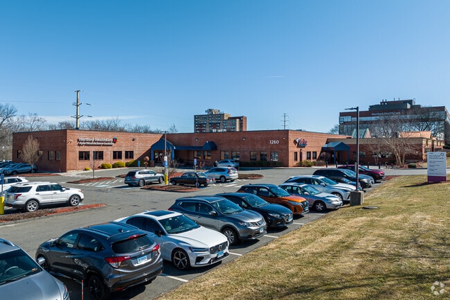
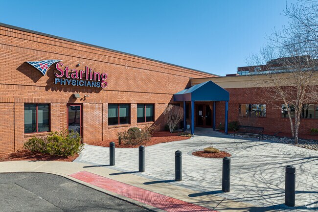
1260 Silas Deane Hwy
Medicalbuilding
Capitol
RC
Connecticut
B and X Area of moderate flood hazard, usually the area between the limits of the 100-year and 500-year floods.
3.36 AC
2025
Wethersfield
2025
Hartford
492600
Hartford-West Hartford-East Hartford, CT
55,914 SF
WETH-000237-000000-000010
NEARBY LISTINGS FOR SALE OR LEASE
DEMOGRAPHICS near 1260 Silas Deane Hwy
1 mile
3 mile
5 mile
2025 Total Population
6,472
48,889
166,335
2030 Population
6,632
49,857
168,960
Pop Growth 2025-2030
+ 2.47%
+ 1.98%
+ 1.58%
Average Age
44
44
41
2025 Total Households
2,949
20,578
66,763
HH Growth 2025-2030
+ 2.75%
+ 2.07%
+ 1.67%
Median Household Inc
$91,258
$110,268
$86,910
Avg Household Size
2.10
2.30
2.40
2025 Avg HH Vehicles
2.00
2.00
2.00
Median Home Value
$322,346
$341,122
$313,468
Median Year Built
1963
1965
1962
Nearby Places
Map Layers
Map Styles
 Street
 Aerial
Layers
 Traffic
 Biking
Places
Listings with unknown addresses are not visible on the map
- Restaurants
- Banks
- Shops
- Fitness
- Groceries
PUBLIC TRANSPORTATION
COMMUTER RAIL
Hartford (Hartford Line - CONN DOT)
Drive
Walk
Distance
Hartford (Hartford Line - CONN DOT)
12 min
7.2 mi
Hartford Amtrak Station (Amtrak Hartford Line - Amtrak, Northeast Regional - Amtrak, Valley Flyer - Amtrak, Vermonter - Amtrak)
Drive
Walk
Distance
Hartford Amtrak Station (Amtrak Hartford Line - Amtrak, Northeast Regional - Amtrak, Valley Flyer - Amtrak, Vermonter - Amtrak)
13 min
7.3 mi
AIRPORT
Bradley International
Drive
Walk
Distance
Bradley International
42 min
23.5 mi
Freight Ports
Port of New Haven
Drive
Walk
Distance
Port of New Haven
44 min
32.8 mi
SALE & LEASE HISTORY
LISTING DATE
SALE/LEASE

Feb 11, 2021
For Lease
Dec 30, 2022
For Lease
Dec 05, 2022
For Lease
Dec 02, 2022
For Lease
Nearby Properties
Address
Land Use
TOTAL SIZE
Lot Size
Zoning
Address
Land Use
TOTAL SIZE
Lot Size
Zoning
81,507 SF
21.60 AC
R-20
Address
Land Use
TOTAL SIZE
Lot Size
Zoning
33.30 AC
R-20
Address
Land Use
TOTAL SIZE
Lot Size
Zoning
254,786 SF
36 AC
A
Address
Land Use
TOTAL SIZE
Lot Size
Zoning
3,416 SF
19.31 AC
SRD
Address
Land Use
TOTAL SIZE
Lot Size
Zoning
87,037 SF
10.44 AC
R-20
Address
Land Use
TOTAL SIZE
Lot Size
Zoning
310,582 SF
32.72 AC
OP
Address
Land Use
TOTAL SIZE
Lot Size
Zoning
116,979 SF
17 AC
B
Address
Land Use
TOTAL SIZE
Lot Size
Zoning
1.99 AC
C
Address
Land Use
TOTAL SIZE
Lot Size
Zoning
9.09 AC
R-20
Address
Land Use
TOTAL SIZE
Lot Size
Zoning
188,427 SF
8.55 AC
SRD
Address
Land Use
TOTAL SIZE
Lot Size
Zoning
Address
Land Use
TOTAL SIZE
Lot Size
Zoning
11.95 AC
PAD
Address
Land Use
TOTAL SIZE
Lot Size
Zoning
68,967 SF
11.25 AC
O
Address
Land Use
TOTAL SIZE
Lot Size
Zoning
15.12 AC
PAD
Address
Land Use
TOTAL SIZE
Lot Size
Zoning
10.45 AC
R-20
Address
Land Use
TOTAL SIZE
Lot Size
Zoning
83,468 SF
6.65 AC
R-20
Address
Land Use
TOTAL SIZE
Lot Size
Zoning
Address
Land Use
TOTAL SIZE
Lot Size
Zoning
145,956 SF
11.27 AC
OP
Address
Land Use
TOTAL SIZE
Lot Size
Zoning
13.85 AC
R-20
Address
Land Use
TOTAL SIZE
Lot Size
Zoning
49,724 SF
9.02 AC
OP
Address
Land Use
TOTAL SIZE
Lot Size
Zoning
13.61 AC
RC
Address
Land Use
TOTAL SIZE
Lot Size
Zoning
8.56 AC
TC
Address
Land Use
TOTAL SIZE
Lot Size
Zoning
186,777 SF
21.25 AC
RC
Address
Land Use
TOTAL SIZE
Lot Size
Zoning
172,155 SF
57.35 AC
OP
Address
Land Use
TOTAL SIZE
Lot Size
Zoning
38.84 AC
RC
Address
Land Use
TOTAL SIZE
Lot Size
Zoning
75,478 SF
14.40 AC
A1
Address
Land Use
TOTAL SIZE
Lot Size
Zoning
175,694 SF
9.03 AC
BP
Address
Land Use
TOTAL SIZE
Lot Size
Zoning
97.02 AC
A1
Address
Land Use
TOTAL SIZE
Lot Size
Zoning
57,862 SF
23.20 AC
AA
Address
Land Use
TOTAL SIZE
Lot Size
Zoning
68,601 SF
5.36 AC
SRD
The World's #1 Commercial Real Estate Marketplace
Connect with us
© 2026 CoStar Group
The information above has been obtained from sources believed reliable. While we do not doubt its accuracy we have not verified it and make no guarantee, warranty or representation about it. It is your responsibility to independently confirm its accuracy and completeness. Any projections, opinions, assumptions, or estimates used are for example only and do not represent the current or future performance of the property. The value of this transaction to you depends on tax and other factors which should be evaluated by your tax, financial, and legal advisors. You and your advisors should conduct a careful, independent investigation of the property to determine to your satisfaction the suitability of the property for your needs.