Property Record
1260 State Route 303, Streetsboro, OH 44241


NEARBY LISTINGS FOR SALE OR LEASE
Property Detail
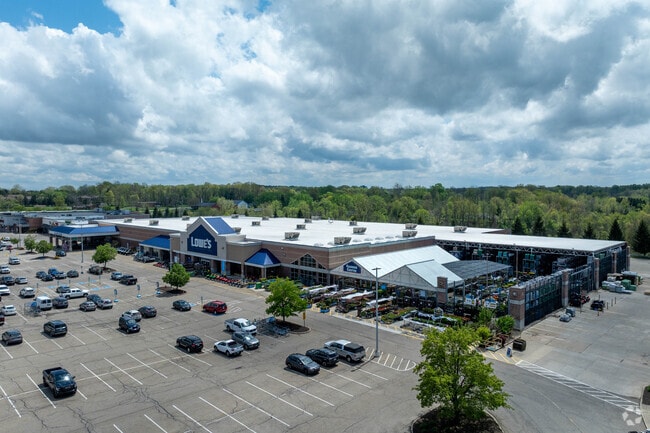
1260 State Route 303
Akron, OH
Streetsboro Crossing
35-055-00-00-039-017
STREETSBORO CROSSING LOT A-1-A1-1-B-2 TIF AGREEMENT PCL 30-999 30-999
Regionalshoppingcenterormallwithanchorstore
Portage
X
Ohio
39133C0126D
a-1
2024
19.65 AC
2024
Portage County
600401
Cleveland
88,934 SF
DEMOGRAPHICS near 1260 State Route 303
1 Mile
3 Mile
5 Mile
2024 Total Population
6,135
20,300
46,960
2029 Population
6,382
20,712
47,169
Pop Growth 2024-2029
+ 4.03%
+ 2.03%
+ 0.45%
Average Age
40
42
42
2024 Total Households
2,722
8,566
18,286
HH Growth 2024-2029
+ 4.08%
+ 2.02%
+ 0.51%
Median Household Inc
$72,664
$77,127
$96,207
Avg Household Size
2.20
2.30
2.50
2024 Avg HH Vehicles
2.00
2.00
2.00
Median Home Value
$186,841
$208,181
$272,792
Median Year Built
1988
1991
1983
Nearby Places
Map Layers
Map Styles
 Street
 Aerial
- Restaurants
- Banks
- Shops
- Fitness
- Groceries
PUBLIC TRANSPORTATION
AIRPORT
Akron-Canton Regional
DRIVE
WALK
Distance
Akron-Canton Regional
46 min
32.0 mi
Cleveland-Hopkins International
DRIVE
WALK
Distance
Cleveland-Hopkins International
48 min
36.3 mi
Freight Ports
Port of Toledo
DRIVE
WALK
Distance
Port of Toledo
151 min
130.8 mi
SALE & LEASE HISTORY
LISTING DATE
SALE/LEASE

Mar 04, 2020
For Lease
Jun 27, 2019
For Lease
Jul 27, 2021
For Lease
Nearby Properties
Address
Land Use
TOTAL SIZE
Lot Size
Zoning
Address
Land Use
TOTAL SIZE
Lot Size
Zoning
650,506 SF
57.86 AC
Address
Land Use
TOTAL SIZE
Lot Size
Zoning
435,216 SF
31.88 AC
Address
Land Use
TOTAL SIZE
Lot Size
Zoning
117,571 SF
119.98 AC
Address
Land Use
TOTAL SIZE
Lot Size
Zoning
257,381 SF
28.99 AC
Address
Land Use
TOTAL SIZE
Lot Size
Zoning
441,158 SF
74.07 AC
Address
Land Use
TOTAL SIZE
Lot Size
Zoning
368,060 SF
27.87 AC
Address
Land Use
TOTAL SIZE
Lot Size
Zoning
73,295 SF
12.75 AC
Address
Land Use
TOTAL SIZE
Lot Size
Zoning
418,878 SF
51.63 AC
Address
Land Use
TOTAL SIZE
Lot Size
Zoning
348,301 SF
27.65 AC
Address
Land Use
TOTAL SIZE
Lot Size
Zoning
340,850 SF
29.70 AC
Address
Land Use
TOTAL SIZE
Lot Size
Zoning
155,932 SF
12.94 AC
Address
Land Use
TOTAL SIZE
Lot Size
Zoning
30.10 AC
Address
Land Use
TOTAL SIZE
Lot Size
Zoning
129,487 SF
33.05 AC
Address
Land Use
TOTAL SIZE
Lot Size
Zoning
206,907 SF
1.11 AC
Address
Land Use
TOTAL SIZE
Lot Size
Zoning
149,850 SF
24.08 AC
Address
Land Use
TOTAL SIZE
Lot Size
Zoning
22,052 SF
12.52 AC
Address
Land Use
TOTAL SIZE
Lot Size
Zoning
87,010 SF
22.96 AC
Address
Land Use
TOTAL SIZE
Lot Size
Zoning
251,864 SF
22.07 AC
Address
Land Use
TOTAL SIZE
Lot Size
Zoning
194,632 SF
19.41 AC
Address
Land Use
TOTAL SIZE
Lot Size
Zoning
88,898 SF
5.98 AC
Address
Land Use
TOTAL SIZE
Lot Size
Zoning
168,429 SF
14.81 AC
Address
Land Use
TOTAL SIZE
Lot Size
Zoning
145,400 SF
30.70 AC
Address
Land Use
TOTAL SIZE
Lot Size
Zoning
61,694 SF
5.10 AC
Address
Land Use
TOTAL SIZE
Lot Size
Zoning
175,496 SF
30 AC
Address
Land Use
TOTAL SIZE
Lot Size
Zoning
150,755 SF
15.98 AC
Address
Land Use
TOTAL SIZE
Lot Size
Zoning
150,504 SF
13.95 AC
Address
Land Use
TOTAL SIZE
Lot Size
Zoning
50,000 SF
5.35 AC
Address
Land Use
TOTAL SIZE
Lot Size
Zoning
130,069 SF
8.56 AC
Address
Land Use
TOTAL SIZE
Lot Size
Zoning
127,518 SF
11.39 AC
The World's #1 Commercial Real Estate Marketplace
Connect with us
© 2025 CoStar Group
The information above has been obtained from sources believed reliable. While we do not doubt its accuracy we have not verified it and make no guarantee, warranty or representation about it. It is your responsibility to independently confirm its accuracy and completeness. Any projections, opinions, assumptions, or estimates used are for example only and do not represent the current or future performance of the property. The value of this transaction to you depends on tax and other factors which should be evaluated by your tax, financial, and legal advisors. You and your advisors should conduct a careful, independent investigation of the property to determine to your satisfaction the suitability of the property for your needs.