Property Record
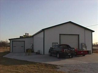
12619 Nettle Dr, Neosho, MO 64850

Property Detail
12619 Nettle Dr
16-8.0-34-000-000-014.004
BEG 60 W NE COR NW1/4 SE1/4 S 267.82 W 78.44 NE TO RD E TO POB
Officebuilding
Newton
B and X Area of moderate flood hazard, usually the area between the limits of the 100-year and 500-year floods.
Missouri
2023
0.81 AC
2024
Missouri South Area
020800
Other Market Areas
3,360 SF
Joplin, MO-KS
NEARBY LISTINGS FOR SALE OR LEASE
DEMOGRAPHICS near 12619 Nettle Dr
1 mile
3 mile
5 mile
2025 Total Population
957
11,531
19,772
2030 Population
996
11,981
20,581
Pop Growth 2025-2030
+ 4.08%
+ 3.90%
+ 4.09%
Average Age
41
39
39
2025 Total Households
352
4,189
7,351
HH Growth 2025-2030
+ 3.98%
+ 3.94%
+ 4.11%
Median Household Inc
$74,796
$66,294
$60,225
Avg Household Size
2.60
2.60
2.60
2025 Avg HH Vehicles
2.00
2.00
2.00
Median Home Value
$214,948
$183,807
$177,568
Median Year Built
1988
1979
1977
Nearby Places
Map Layers
Map Styles
 Street
 Aerial
Layers
 Traffic
 Biking
Places
Listings with unknown addresses are not visible on the map
- Restaurants
- Banks
- Shops
- Fitness
- Groceries
Nearby Properties
Address
Land Use
TOTAL SIZE
Lot Size
Zoning
Address
Land Use
TOTAL SIZE
Lot Size
Zoning
159,394 SF
28.53 AC
Address
Land Use
TOTAL SIZE
Lot Size
Zoning
555,320 SF
29.75 AC
Address
Land Use
TOTAL SIZE
Lot Size
Zoning
110,944 SF
11.32 AC
Address
Land Use
TOTAL SIZE
Lot Size
Zoning
168,000 SF
6.90 AC
Address
Land Use
TOTAL SIZE
Lot Size
Zoning
20,896 SF
24.28 AC
Address
Land Use
TOTAL SIZE
Lot Size
Zoning
74,200 SF
9.27 AC
Address
Land Use
TOTAL SIZE
Lot Size
Zoning
24,100 SF
3.02 AC
Address
Land Use
TOTAL SIZE
Lot Size
Zoning
15,458 SF
50.87 AC
Address
Land Use
TOTAL SIZE
Lot Size
Zoning
13,965 SF
3.06 AC
Address
Land Use
TOTAL SIZE
Lot Size
Zoning
12,934 SF
2.82 AC
Address
Land Use
TOTAL SIZE
Lot Size
Zoning
187,700 SF
8.90 AC
Address
Land Use
TOTAL SIZE
Lot Size
Zoning
73,468 SF
8.11 AC
Address
Land Use
TOTAL SIZE
Lot Size
Zoning
21,414 SF
2 AC
Address
Land Use
TOTAL SIZE
Lot Size
Zoning
174,252 SF
24.82 AC
Address
Land Use
TOTAL SIZE
Lot Size
Zoning
43,789 SF
5.39 AC
Address
Land Use
TOTAL SIZE
Lot Size
Zoning
53,674 SF
9.92 AC
Address
Land Use
TOTAL SIZE
Lot Size
Zoning
14,722 SF
1.51 AC
Address
Land Use
TOTAL SIZE
Lot Size
Zoning
184,750 SF
16.09 AC
Address
Land Use
TOTAL SIZE
Lot Size
Zoning
37,976 SF
3.30 AC
Address
Land Use
TOTAL SIZE
Lot Size
Zoning
36,841 SF
4.35 AC
Address
Land Use
TOTAL SIZE
Lot Size
Zoning
34,250 SF
2.06 AC
Address
Land Use
TOTAL SIZE
Lot Size
Zoning
20,728 SF
14.64 AC
Address
Land Use
TOTAL SIZE
Lot Size
Zoning
21,916 SF
3.70 AC
Address
Land Use
TOTAL SIZE
Lot Size
Zoning
22,740 SF
6.10 AC
Address
Land Use
TOTAL SIZE
Lot Size
Zoning
24,170 SF
4.03 AC
Address
Land Use
TOTAL SIZE
Lot Size
Zoning
41,577 SF
2 AC
The World's #1 Commercial Real Estate Marketplace
Connect with us
© 2026 CoStar Group
The information above has been obtained from sources believed reliable. While we do not doubt its accuracy we have not verified it and make no guarantee, warranty or representation about it. It is your responsibility to independently confirm its accuracy and completeness. Any projections, opinions, assumptions, or estimates used are for example only and do not represent the current or future performance of the property. The value of this transaction to you depends on tax and other factors which should be evaluated by your tax, financial, and legal advisors. You and your advisors should conduct a careful, independent investigation of the property to determine to your satisfaction the suitability of the property for your needs.