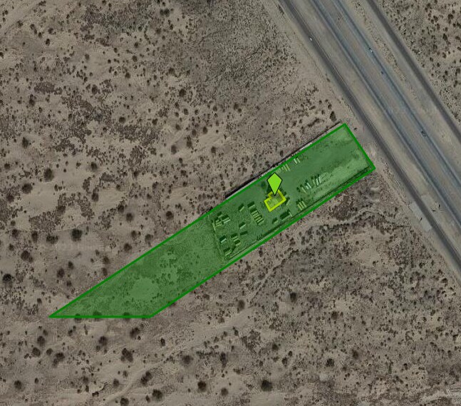
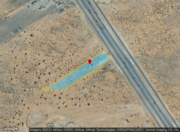
Property Record
12620 E Gateway Blvd E, El Paso, TX 79927
NEARBY LISTINGS FOR SALE OR LEASE
Property Detail
12620 E Gateway Blvd E
El Paso, TX
Leigh Clark Surv 298 Abst 6262
X298-000-0000-0130
LEIGH CLARK SURV 298 ABST 6262 TR 17 (8.20 AC)
Commercialnec
El Paso
2024
Texas
2025
8.20 AC
010408
Outlying El Paso County
3,488 SF
El Paso
DEMOGRAPHICS near 12620 E Gateway Blvd E
1 Mile
3 Mile
5 Mile
2024 Total Population
465
19,999
91,003
2029 Population
497
20,512
92,040
Pop Growth 2024-2029
+ 6.88%
+ 2.57%
+ 1.14%
Average Age
34
34
34
2024 Total Households
129
5,802
26,408
HH Growth 2024-2029
+ 6.98%
+ 2.46%
+ 1.11%
Median Household Inc
$24,230
$45,093
$47,632
Avg Household Size
3.50
3.40
3.40
2024 Avg HH Vehicles
2.00
2.00
2.00
Median Home Value
$75,735
$123,150
$130,591
Median Year Built
2000
1999
1999
Nearby Places
Map Layers
Map Styles
 Street
 Aerial
- Restaurants
- Banks
- Shops
- Fitness
- Groceries
PUBLIC TRANSPORTATION
AIRPORT
El Paso International
DRIVE
WALK
Distance
El Paso International
39 min
23.5 mi
Freight Ports
Port of Corpus Christi
DRIVE
WALK
Distance
Port of Corpus Christi
659 min
674.1 mi
Nearby Properties
Address
Land Use
TOTAL SIZE
Lot Size
Zoning
Address
Land Use
TOTAL SIZE
Lot Size
Zoning
953,000 SF
45.97 AC
M2
Address
Land Use
TOTAL SIZE
Lot Size
Zoning
618,222 SF
25.18 AC
M2
Address
Land Use
TOTAL SIZE
Lot Size
Zoning
450,900 SF
20.46 AC
M2
Address
Land Use
TOTAL SIZE
Lot Size
Zoning
130,100 SF
41.51 AC
Address
Land Use
TOTAL SIZE
Lot Size
Zoning
107,280 SF
20.64 AC
Address
Land Use
TOTAL SIZE
Lot Size
Zoning
156,914 SF
10.37 AC
Address
Land Use
TOTAL SIZE
Lot Size
Zoning
293,760 SF
15.59 AC
Address
Land Use
TOTAL SIZE
Lot Size
Zoning
293,760 SF
16.87 AC
Address
Land Use
TOTAL SIZE
Lot Size
Zoning
117,512 SF
20.84 AC
Address
Land Use
TOTAL SIZE
Lot Size
Zoning
19,227 SF
24.06 AC
Address
Land Use
TOTAL SIZE
Lot Size
Zoning
138,279 SF
17.42 AC
Address
Land Use
TOTAL SIZE
Lot Size
Zoning
38,909 SF
37.07 AC
Address
Land Use
TOTAL SIZE
Lot Size
Zoning
85,524 SF
12 AC
Address
Land Use
TOTAL SIZE
Lot Size
Zoning
242,991 SF
8.81 AC
M2
Address
Land Use
TOTAL SIZE
Lot Size
Zoning
1 SF
Address
Land Use
TOTAL SIZE
Lot Size
Zoning
85,718 SF
20 AC
Address
Land Use
TOTAL SIZE
Lot Size
Zoning
49,037 SF
24.91 AC
C2
Address
Land Use
TOTAL SIZE
Lot Size
Zoning
259,200 SF
16.09 AC
Address
Land Use
TOTAL SIZE
Lot Size
Zoning
30,058 SF
0.99 AC
Address
Land Use
TOTAL SIZE
Lot Size
Zoning
72,577 SF
11.87 AC
Address
Land Use
TOTAL SIZE
Lot Size
Zoning
24,288 SF
12.92 AC
Address
Land Use
TOTAL SIZE
Lot Size
Zoning
22,600 SF
3.08 AC
Address
Land Use
TOTAL SIZE
Lot Size
Zoning
42,016 SF
6 AC
Address
Land Use
TOTAL SIZE
Lot Size
Zoning
20,740 SF
5 AC
Address
Land Use
TOTAL SIZE
Lot Size
Zoning
38,755 SF
8.42 AC
Address
Land Use
TOTAL SIZE
Lot Size
Zoning
43,275 SF
4 AC
Address
Land Use
TOTAL SIZE
Lot Size
Zoning
23,646 SF
14.35 AC
Address
Land Use
TOTAL SIZE
Lot Size
Zoning
14,587 SF
2.68 AC
Address
Land Use
TOTAL SIZE
Lot Size
Zoning
8,024 SF
2.60 AC
Address
Land Use
TOTAL SIZE
Lot Size
Zoning
27,000 SF
9.08 AC
The World's #1 Commercial Real Estate Marketplace
Connect with us
© 2025 CoStar Group
The information above has been obtained from sources believed reliable. While we do not doubt its accuracy we have not verified it and make no guarantee, warranty or representation about it. It is your responsibility to independently confirm its accuracy and completeness. Any projections, opinions, assumptions, or estimates used are for example only and do not represent the current or future performance of the property. The value of this transaction to you depends on tax and other factors which should be evaluated by your tax, financial, and legal advisors. You and your advisors should conduct a careful, independent investigation of the property to determine to your satisfaction the suitability of the property for your needs.