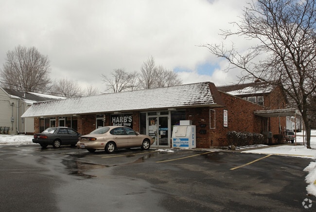
Property Record
12671 State Rd, North Royalton, OH 44133


Current Lease Availabilities
NEARBY LISTINGS FOR SALE OR LEASE
Property Detail
12671 State Rd
Cleveland-Elyria, OH
Royalton Sec 19
488-10-003
19
Storebuilding
Cuyahoga
X
Ohio
39035C0303E
19
2024
0.87 AC
2024
Southwest
175105
Cleveland
5,940 SF
DEMOGRAPHICS near 12671 State Rd
1 Mile
3 Mile
5 Mile
2024 Total Population
5,718
43,768
127,176
2029 Population
5,565
42,509
123,592
Pop Growth 2024-2029
(2.68%)
(2.88%)
(2.82%)
Average Age
44
44
44
2024 Total Households
2,396
18,922
53,958
HH Growth 2024-2029
(2.80%)
(3.00%)
(3.01%)
Median Household Inc
$82,343
$77,739
$76,744
Avg Household Size
2.40
2.30
2.30
2024 Avg HH Vehicles
2.00
2.00
2.00
Median Home Value
$274,964
$248,993
$217,538
Median Year Built
1982
1979
1971
Nearby Places
Map Layers
Map Styles
 Street
 Aerial
- Restaurants
- Banks
- Shops
- Fitness
- Groceries
PUBLIC TRANSPORTATION
COMMUTER RAIL
Canal Exploration Center (National Park Scenic Railway - Cuyahoga Valley Scenic Railroad)
DRIVE
WALK
Distance
Canal Exploration Center (National Park Scenic Railway - Cuyahoga Valley Scenic Railroad)
18 min
8.4 mi
AIRPORT
Cleveland-Hopkins International
DRIVE
WALK
Distance
Cleveland-Hopkins International
27 min
13.8 mi
Freight Ports
Port of Toledo
DRIVE
WALK
Distance
Port of Toledo
139 min
110.4 mi
Nearby Properties
Address
Land Use
TOTAL SIZE
Lot Size
Zoning
Address
Land Use
TOTAL SIZE
Lot Size
Zoning
485,330 SF
47.02 AC
TCD
Address
Land Use
TOTAL SIZE
Lot Size
Zoning
154,702 SF
23.37 AC
PF
Address
Land Use
TOTAL SIZE
Lot Size
Zoning
168,729 SF
11.56 AC
GB
Address
Land Use
TOTAL SIZE
Lot Size
Zoning
229,190 SF
25.06 AC
GB
Address
Land Use
TOTAL SIZE
Lot Size
Zoning
17,682 SF
36.78 AC
MF1
Address
Land Use
TOTAL SIZE
Lot Size
Zoning
39,848 SF
48 AC
RM-D
Address
Land Use
TOTAL SIZE
Lot Size
Zoning
118,375 SF
24.17 AC
RM-D
Address
Land Use
TOTAL SIZE
Lot Size
Zoning
614 SF
19.13 AC
RRZ
Address
Land Use
TOTAL SIZE
Lot Size
Zoning
166,699 SF
65.80 AC
B-5
Address
Land Use
TOTAL SIZE
Lot Size
Zoning
149,522 SF
19.09 AC
PF
Address
Land Use
TOTAL SIZE
Lot Size
Zoning
48,682 SF
4.64 AC
C-4
Address
Land Use
TOTAL SIZE
Lot Size
Zoning
28,189 SF
15.33 AC
B-1OR2
Address
Land Use
TOTAL SIZE
Lot Size
Zoning
10,560 SF
22.12 AC
RM-D
Address
Land Use
TOTAL SIZE
Lot Size
Zoning
10,560 SF
19.12 AC
RM-D
Address
Land Use
TOTAL SIZE
Lot Size
Zoning
74,988 SF
19.16 AC
RM-D
Address
Land Use
TOTAL SIZE
Lot Size
Zoning
178,194 SF
18.93 AC
RM-D
Address
Land Use
TOTAL SIZE
Lot Size
Zoning
204,594 SF
22.97 AC
R1-A
Address
Land Use
TOTAL SIZE
Lot Size
Zoning
83,969 SF
10.94 AC
PF
Address
Land Use
TOTAL SIZE
Lot Size
Zoning
24,900 SF
4.42 AC
B-1OR2
Address
Land Use
TOTAL SIZE
Lot Size
Zoning
55,332 SF
3.01 AC
E-2
Address
Land Use
TOTAL SIZE
Lot Size
Zoning
89,807 SF
7.29 AC
Address
Land Use
TOTAL SIZE
Lot Size
Zoning
59,813 SF
5.56 AC
Address
Land Use
TOTAL SIZE
Lot Size
Zoning
123.70 AC
A-1
Address
Land Use
TOTAL SIZE
Lot Size
Zoning
128,610 SF
7.71 AC
C-2
Address
Land Use
TOTAL SIZE
Lot Size
Zoning
102,446 SF
8.21 AC
TCD
Address
Land Use
TOTAL SIZE
Lot Size
Zoning
47,988 SF
10.74 AC
LB
Address
Land Use
TOTAL SIZE
Lot Size
Zoning
29,905 SF
5.55 AC
LB
Address
Land Use
TOTAL SIZE
Lot Size
Zoning
132,978 SF
8.71 AC
MF-1
Address
Land Use
TOTAL SIZE
Lot Size
Zoning
140,360 SF
2.55 AC
MF-1
Address
Land Use
TOTAL SIZE
Lot Size
Zoning
95,374 SF
20.64 AC
GI
The World's #1 Commercial Real Estate Marketplace
Connect with us
© 2026 CoStar Group
The information above has been obtained from sources believed reliable. While we do not doubt its accuracy we have not verified it and make no guarantee, warranty or representation about it. It is your responsibility to independently confirm its accuracy and completeness. Any projections, opinions, assumptions, or estimates used are for example only and do not represent the current or future performance of the property. The value of this transaction to you depends on tax and other factors which should be evaluated by your tax, financial, and legal advisors. You and your advisors should conduct a careful, independent investigation of the property to determine to your satisfaction the suitability of the property for your needs.