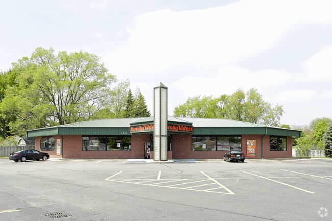
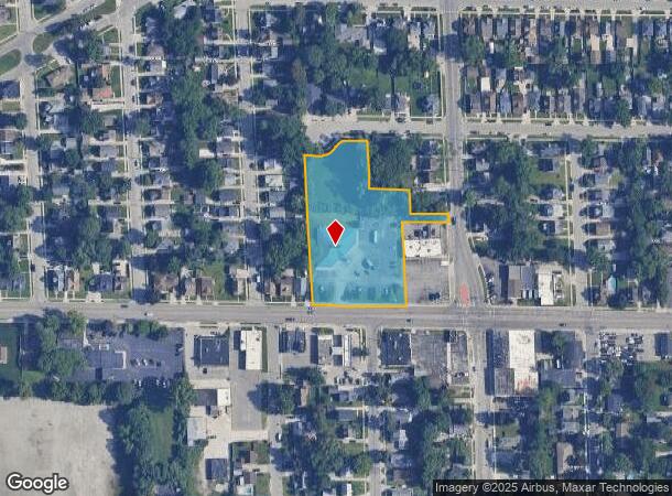
Property Record
1263 Burton St Sw, Wyoming, MI 49509

Current Lease Availabilities
NEARBY LISTINGS FOR SALE OR LEASE
Property Detail
1263 Burton St Sw
Grand Rapids-Wyoming, MI
Kroodsma & Dehoop 2Nd Addition
41-17-02-379-032
LOT 38 EX E 100 FT ALSO LOT 39 EX N 20 FT OF E 100 FT ALSO LOT 40 EX COM AT NW COR THEREOF TH S ALONG W LOT LINE 40.0 FT TH S
Commercialnec
Kent
X
Michigan
26081C0412D
38-46
2024
1.77 AC
2025
Central Grand Rapids
013300
West Michigan
6,244 SF
DEMOGRAPHICS near 1263 Burton St Sw
1 Mile
3 Mile
5 Mile
2024 Total Population
12,538
105,839
266,012
2029 Population
12,538
106,312
267,515
Pop Growth 2024-2029
0.00%
+ 0.45%
+ 0.57%
Average Age
34
35
36
2024 Total Households
3,926
38,880
104,283
HH Growth 2024-2029
+ 0.08%
+ 0.60%
+ 0.63%
Median Household Inc
$52,051
$54,841
$62,421
Avg Household Size
3.00
2.60
2.40
2024 Avg HH Vehicles
2.00
2.00
2.00
Median Home Value
$128,207
$155,143
$196,384
Median Year Built
1952
1954
1957
Nearby Places
Map Layers
Map Styles
 Street
 Aerial
- Restaurants
- Banks
- Shops
- Fitness
- Groceries
PUBLIC TRANSPORTATION
COMMUTER RAIL
DRIVE
WALK
Distance
6 min
3.4 mi
AIRPORT
Gerald R Ford International
DRIVE
WALK
Distance
Gerald R Ford International
23 min
13.1 mi
Nearby Properties
Address
Land Use
TOTAL SIZE
Lot Size
Zoning
Address
Land Use
TOTAL SIZE
Lot Size
Zoning
557,931 SF
2.12 AC
TN-CC
Address
Land Use
TOTAL SIZE
Lot Size
Zoning
265,905 SF
1.99 AC
TN-CC
Address
Land Use
TOTAL SIZE
Lot Size
Zoning
347,500 SF
1.51 AC
TN-CC
Address
Land Use
TOTAL SIZE
Lot Size
Zoning
138,122 SF
1.01 AC
TN-CC
Address
Land Use
TOTAL SIZE
Lot Size
Zoning
398,607 SF
33.51 AC
R4
Address
Land Use
TOTAL SIZE
Lot Size
Zoning
164,591 SF
1.28 AC
TN-CC
Address
Land Use
TOTAL SIZE
Lot Size
Zoning
Address
Land Use
TOTAL SIZE
Lot Size
Zoning
201,100 SF
0.90 AC
TN-CC
Address
Land Use
TOTAL SIZE
Lot Size
Zoning
88,327 SF
2.74 AC
TN-CC
Address
Land Use
TOTAL SIZE
Lot Size
Zoning
87.39 AC
I2
Address
Land Use
TOTAL SIZE
Lot Size
Zoning
254,941 SF
0.79 AC
TN-CC
Address
Land Use
TOTAL SIZE
Lot Size
Zoning
269,990 SF
1.28 AC
TN-CC
Address
Land Use
TOTAL SIZE
Lot Size
Zoning
3.31 AC
TN-CC
Address
Land Use
TOTAL SIZE
Lot Size
Zoning
269,990 SF
1.28 AC
TN-CC
Address
Land Use
TOTAL SIZE
Lot Size
Zoning
3.31 AC
TN-CC
Address
Land Use
TOTAL SIZE
Lot Size
Zoning
536,296 SF
26.16 AC
SD-IT
Address
Land Use
TOTAL SIZE
Lot Size
Zoning
179,436 SF
24.94 AC
I2
Address
Land Use
TOTAL SIZE
Lot Size
Zoning
348,367 SF
12.15 AC
SD-IT
Address
Land Use
TOTAL SIZE
Lot Size
Zoning
29.13 AC
Address
Land Use
TOTAL SIZE
Lot Size
Zoning
293,441 SF
18 AC
I-1
Address
Land Use
TOTAL SIZE
Lot Size
Zoning
251,562 SF
15.56 AC
MZ
Address
Land Use
TOTAL SIZE
Lot Size
Zoning
31,365 SF
TN-TCC
Address
Land Use
TOTAL SIZE
Lot Size
Zoning
162,228 SF
14.31 AC
R4
Address
Land Use
TOTAL SIZE
Lot Size
Zoning
135,254 SF
0.26 AC
TN-CC
Address
Land Use
TOTAL SIZE
Lot Size
Zoning
131,004 SF
0.64 AC
TN-CC
Address
Land Use
TOTAL SIZE
Lot Size
Zoning
133,564 SF
0.46 AC
TN-CC
Address
Land Use
TOTAL SIZE
Lot Size
Zoning
147,340 SF
0.63 AC
TN-CC
Address
Land Use
TOTAL SIZE
Lot Size
Zoning
89,565 SF
0.16 AC
TN-CC
Address
Land Use
TOTAL SIZE
Lot Size
Zoning
122,570 SF
1.17 AC
TN-TCC
Address
Land Use
TOTAL SIZE
Lot Size
Zoning
123,066 SF
0.30 AC
TN-CC
The World's #1 Commercial Real Estate Marketplace
Connect with us
© 2025 CoStar Group
The information above has been obtained from sources believed reliable. While we do not doubt its accuracy we have not verified it and make no guarantee, warranty or representation about it. It is your responsibility to independently confirm its accuracy and completeness. Any projections, opinions, assumptions, or estimates used are for example only and do not represent the current or future performance of the property. The value of this transaction to you depends on tax and other factors which should be evaluated by your tax, financial, and legal advisors. You and your advisors should conduct a careful, independent investigation of the property to determine to your satisfaction the suitability of the property for your needs.