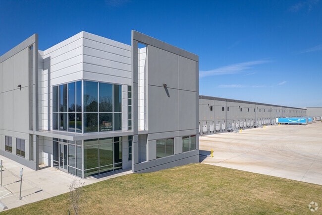
Property Record
12631 Main St, Houston, TX 77035

NEARBY LISTINGS FOR SALE OR LEASE
Property Detail
12631 Main St
Houston-The Woodlands-Sugar Land, TX
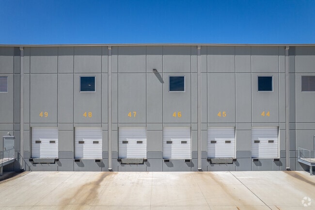
Post Oak Logistics Park
1457050010001
RES A BLK 1 POST OAK LOGISTICS PARK
Outdoorrecreationbeachmountaindesert
Harris
2024
Texas
2025
31.65 AC
330301
Southwest Far
371,335 SF
Houston
DEMOGRAPHICS near 12631 Main St
1 Mile
3 Mile
5 Mile
2024 Total Population
12,793
132,663
347,563
2029 Population
12,972
137,020
365,230
Pop Growth 2024-2029
+ 1.40%
+ 3.28%
+ 5.08%
Average Age
35
37
37
2024 Total Households
3,732
45,959
123,950
HH Growth 2024-2029
+ 1.47%
+ 3.17%
+ 4.90%
Median Household Inc
$58,667
$56,470
$57,084
Avg Household Size
3.30
2.80
2.70
2024 Avg HH Vehicles
2.00
2.00
2.00
Median Home Value
$160,877
$185,812
$211,960
Median Year Built
2000
1974
1979
Nearby Places
Map Layers
Map Styles
 Street
 Aerial
- Restaurants
- Banks
- Shops
- Fitness
- Groceries
PUBLIC TRANSPORTATION
AIRPORT
William P Hobby
DRIVE
WALK
Distance
William P Hobby
29 min
16.6 mi
George Bush Intcntl/Houston
DRIVE
WALK
Distance
George Bush Intcntl/Houston
42 min
29.4 mi
Freight Ports
Port of Houston
DRIVE
WALK
Distance
Port of Houston
26 min
16.9 mi
SALE & LEASE HISTORY
LISTING DATE
SALE/LEASE

Sep 28, 2022
For Lease
Nearby Properties
Address
Land Use
TOTAL SIZE
Lot Size
Zoning
Address
Land Use
TOTAL SIZE
Lot Size
Zoning
1,139,160 SF
75.11 AC
Address
Land Use
TOTAL SIZE
Lot Size
Zoning
1,202,191 SF
39.08 AC
Address
Land Use
TOTAL SIZE
Lot Size
Zoning
15.46 AC
Address
Land Use
TOTAL SIZE
Lot Size
Zoning
305,512 SF
13.74 AC
Address
Land Use
TOTAL SIZE
Lot Size
Zoning
544,698 SF
15.66 AC
Address
Land Use
TOTAL SIZE
Lot Size
Zoning
640,860 SF
5.31 AC
Address
Land Use
TOTAL SIZE
Lot Size
Zoning
398,772 SF
2.97 AC
Address
Land Use
TOTAL SIZE
Lot Size
Zoning
429,368 SF
27.94 AC
Address
Land Use
TOTAL SIZE
Lot Size
Zoning
297,620 SF
11.01 AC
Address
Land Use
TOTAL SIZE
Lot Size
Zoning
534,800 SF
33.43 AC
Address
Land Use
TOTAL SIZE
Lot Size
Zoning
290,624 SF
3.17 AC
Address
Land Use
TOTAL SIZE
Lot Size
Zoning
242,982 SF
11.56 AC
Address
Land Use
TOTAL SIZE
Lot Size
Zoning
456,076 SF
19.09 AC
Address
Land Use
TOTAL SIZE
Lot Size
Zoning
423,270 SF
32.95 AC
Address
Land Use
TOTAL SIZE
Lot Size
Zoning
414,014 SF
7.77 AC
Address
Land Use
TOTAL SIZE
Lot Size
Zoning
383,515 SF
12.61 AC
Address
Land Use
TOTAL SIZE
Lot Size
Zoning
391,473 SF
17.11 AC
Address
Land Use
TOTAL SIZE
Lot Size
Zoning
186,759 SF
42.60 AC
Address
Land Use
TOTAL SIZE
Lot Size
Zoning
434,744 SF
16.74 AC
Address
Land Use
TOTAL SIZE
Lot Size
Zoning
240,000 SF
12.45 AC
Address
Land Use
TOTAL SIZE
Lot Size
Zoning
209,728 SF
11.93 AC
Address
Land Use
TOTAL SIZE
Lot Size
Zoning
191,931 SF
8.25 AC
Address
Land Use
TOTAL SIZE
Lot Size
Zoning
411,605 SF
19.51 AC
Address
Land Use
TOTAL SIZE
Lot Size
Zoning
Address
Land Use
TOTAL SIZE
Lot Size
Zoning
179,599 SF
16.45 AC
Address
Land Use
TOTAL SIZE
Lot Size
Zoning
237,204 SF
7.65 AC
Address
Land Use
TOTAL SIZE
Lot Size
Zoning
298,857 SF
11.34 AC
Address
Land Use
TOTAL SIZE
Lot Size
Zoning
154,220 SF
2.03 AC
Address
Land Use
TOTAL SIZE
Lot Size
Zoning
158,623 SF
18.27 AC
The World's #1 Commercial Real Estate Marketplace
Connect with us
© 2025 CoStar Group
The information above has been obtained from sources believed reliable. While we do not doubt its accuracy we have not verified it and make no guarantee, warranty or representation about it. It is your responsibility to independently confirm its accuracy and completeness. Any projections, opinions, assumptions, or estimates used are for example only and do not represent the current or future performance of the property. The value of this transaction to you depends on tax and other factors which should be evaluated by your tax, financial, and legal advisors. You and your advisors should conduct a careful, independent investigation of the property to determine to your satisfaction the suitability of the property for your needs.