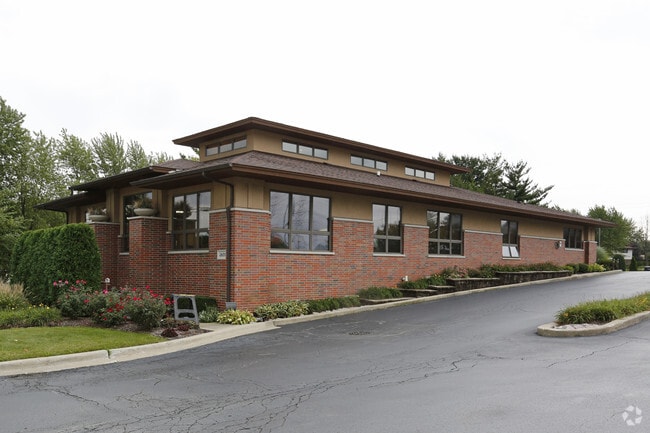
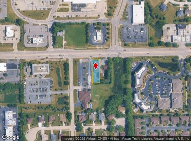
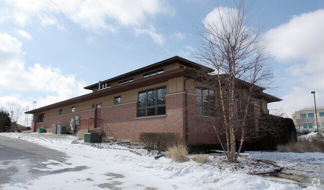
Property Record
12635 W 143Rd St, Homer Glen, IL 60491
NEARBY LISTINGS FOR SALE OR LEASE
Property Detail
12635 W 143Rd St
16-05-12-101-020
THE E 74 FT OF THE N 272.25 FT OF THE W 1064 FT OF THE W1/2 OF THE NW1/4 OF SEC. 12, T36N-R11E. REM AFTER DIV PER PET.#85-61
Commercialnec
Will
X
Illinois
17197C0095G
0.46 AC
2024
Joliet/Central Will
2024
Chicago
881011
Chicago-Naperville-Elgin, IL-IN-WI
5,512 SF
DEMOGRAPHICS near 12635 W 143Rd St
1 Mile
3 Mile
5 Mile
2024 Total Population
8,141
35,621
98,154
2029 Population
8,151
35,108
95,982
Pop Growth 2024-2029
+ 0.12%
(1.44%)
(2.21%)
Average Age
44
43
44
2024 Total Households
2,848
12,407
35,803
HH Growth 2024-2029
+ 0.04%
(1.59%)
(2.54%)
Median Household Inc
$111,376
$115,467
$103,881
Avg Household Size
2.80
2.80
2.70
2024 Avg HH Vehicles
2.00
2.00
2.00
Median Home Value
$345,147
$372,542
$365,825
Median Year Built
1987
1991
1990
Nearby Places
Map Layers
Map Styles
 Street
 Aerial
- Restaurants
- Banks
- Shops
- Fitness
- Groceries
PUBLIC TRANSPORTATION
COMMUTER RAIL
DRIVE
WALK
Distance
8 min
3.9 mi
Orland Park - 153rd Street Station (SouthWest Service - Northeast Illinois Regional Commuter Railroad (Metra))
DRIVE
WALK
Distance
Orland Park - 153rd Street Station (SouthWest Service - Northeast Illinois Regional Commuter Railroad (Metra))
11 min
4.3 mi
AIRPORT
Chicago Midway International
DRIVE
WALK
Distance
Chicago Midway International
31 min
19.9 mi
Chicago O'Hare International
DRIVE
WALK
Distance
Chicago O'Hare International
48 min
31.3 mi
Nearby Properties
Address
Land Use
TOTAL SIZE
Lot Size
Zoning
Address
Land Use
TOTAL SIZE
Lot Size
Zoning
20.43 AC
Address
Land Use
TOTAL SIZE
Lot Size
Zoning
8,577 SF
160 AC
Address
Land Use
TOTAL SIZE
Lot Size
Zoning
13.73 AC
Address
Land Use
TOTAL SIZE
Lot Size
Zoning
3,955 SF
1.82 AC
Address
Land Use
TOTAL SIZE
Lot Size
Zoning
166,107 SF
16.17 AC
Address
Land Use
TOTAL SIZE
Lot Size
Zoning
97,113 SF
44.53 AC
Address
Land Use
TOTAL SIZE
Lot Size
Zoning
103,164 SF
10.87 AC
Address
Land Use
TOTAL SIZE
Lot Size
Zoning
30,540 SF
5.34 AC
Address
Land Use
TOTAL SIZE
Lot Size
Zoning
60,698 SF
8.63 AC
Address
Land Use
TOTAL SIZE
Lot Size
Zoning
3.16 AC
Address
Land Use
TOTAL SIZE
Lot Size
Zoning
13,373 SF
3.78 AC
Address
Land Use
TOTAL SIZE
Lot Size
Zoning
41,449 SF
3.26 AC
Address
Land Use
TOTAL SIZE
Lot Size
Zoning
3,838 SF
4.77 AC
Address
Land Use
TOTAL SIZE
Lot Size
Zoning
40.77 AC
Address
Land Use
TOTAL SIZE
Lot Size
Zoning
92,947 SF
7.49 AC
Address
Land Use
TOTAL SIZE
Lot Size
Zoning
76,322 SF
4.36 AC
Address
Land Use
TOTAL SIZE
Lot Size
Zoning
70,165 SF
3.92 AC
Address
Land Use
TOTAL SIZE
Lot Size
Zoning
2,066 SF
2.50 AC
Address
Land Use
TOTAL SIZE
Lot Size
Zoning
26,415 SF
3.46 AC
Address
Land Use
TOTAL SIZE
Lot Size
Zoning
15,150 SF
1.40 AC
Address
Land Use
TOTAL SIZE
Lot Size
Zoning
1.61 AC
Address
Land Use
TOTAL SIZE
Lot Size
Zoning
Address
Land Use
TOTAL SIZE
Lot Size
Zoning
4,718 SF
2.80 AC
Address
Land Use
TOTAL SIZE
Lot Size
Zoning
22,592 SF
78.60 AC
Address
Land Use
TOTAL SIZE
Lot Size
Zoning
Address
Land Use
TOTAL SIZE
Lot Size
Zoning
21,522 SF
4.85 AC
Address
Land Use
TOTAL SIZE
Lot Size
Zoning
10,150 SF
1.13 AC
Address
Land Use
TOTAL SIZE
Lot Size
Zoning
5,044 SF
2 AC
Address
Land Use
TOTAL SIZE
Lot Size
Zoning
23,912 SF
2.01 AC
Address
Land Use
TOTAL SIZE
Lot Size
Zoning
16,330 SF
2.20 AC
The World's #1 Commercial Real Estate Marketplace
Connect with us
© 2025 CoStar Group
The information above has been obtained from sources believed reliable. While we do not doubt its accuracy we have not verified it and make no guarantee, warranty or representation about it. It is your responsibility to independently confirm its accuracy and completeness. Any projections, opinions, assumptions, or estimates used are for example only and do not represent the current or future performance of the property. The value of this transaction to you depends on tax and other factors which should be evaluated by your tax, financial, and legal advisors. You and your advisors should conduct a careful, independent investigation of the property to determine to your satisfaction the suitability of the property for your needs.