Property Record
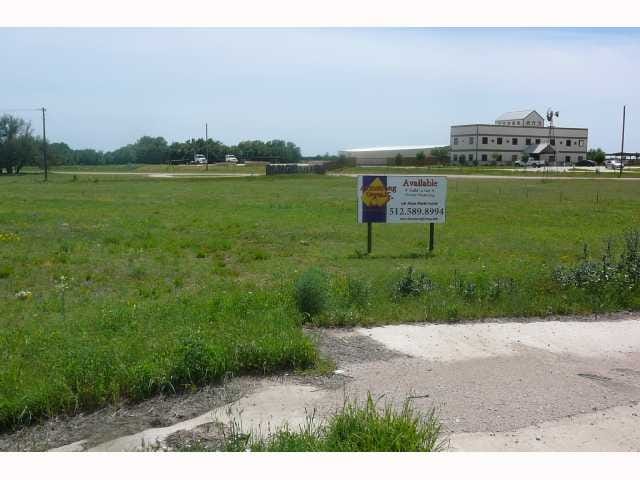
12635 W State Highway 29, Liberty Hill, TX 78642

Property Detail
12635 W State Highway 29
R454342
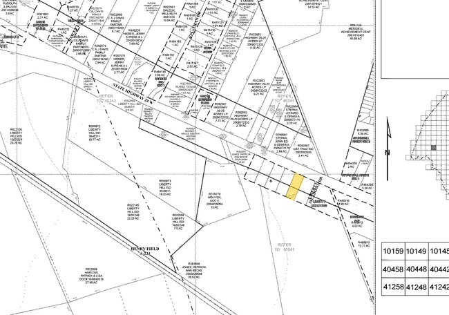
S8479 - LIBERTY MEADOWS, LOT 3C, ACRES 0.88
Commercialnec
WILLIAMSON
3-C3
Texas
B and X Area of moderate flood hazard, usually the area between the limits of the 100-year and 500-year floods.
3c
2024
0.88 AC
2025
Georgetown
020329
Austin
7,788 SF
Austin-Round Rock-San Marcos, TX
NEARBY LISTINGS FOR SALE OR LEASE
DEMOGRAPHICS near 12635 W State Highway 29
1 mile
3 mile
5 mile
2025 Total Population
5,147
20,404
53,733
2030 Population
6,178
24,192
64,226
Pop Growth 2025-2030
+ 20.03%
+ 18.56%
+ 19.53%
Average Age
36
36
36
2025 Total Households
1,803
6,802
18,211
HH Growth 2025-2030
+ 20.47%
+ 18.98%
+ 19.99%
Median Household Inc
$127,998
$126,696
$127,576
Avg Household Size
2.90
3.00
2.90
2025 Avg HH Vehicles
2.00
2.00
2.00
Median Home Value
$482,948
$481,061
$485,066
Median Year Built
2011
2011
2011
Nearby Places
Map Layers
Map Styles
 Street
 Aerial
Transit
 Traffic
 Biking
Places
Listings with unknown addresses are not visible on the map
- Restaurants
- Banks
- Shops
- Fitness
- Groceries
PUBLIC TRANSPORTATION
AIRPORT
Robert Gray AAF
Drive
Walk
Distance
Robert Gray AAF
49 min
35.2 mi
Austin-Bergstrom International
Drive
Walk
Distance
Austin-Bergstrom International
55 min
42.9 mi
Killeen Municipal
Drive
Walk
Distance
Killeen Municipal
55 min
43.9 mi
SALE & LEASE HISTORY
LISTING DATE
SALE/LEASE

May 12, 2021
For Sale
Nearby Properties
Address
Land Use
TOTAL SIZE
Lot Size
Zoning
Address
Land Use
TOTAL SIZE
Lot Size
Zoning
454,000 SF
58.85 AC
Address
Land Use
TOTAL SIZE
Lot Size
Zoning
156,000 SF
67.68 AC
Address
Land Use
TOTAL SIZE
Lot Size
Zoning
312,374 SF
15.77 AC
Address
Land Use
TOTAL SIZE
Lot Size
Zoning
126,361 SF
46.88 AC
Address
Land Use
TOTAL SIZE
Lot Size
Zoning
1,971 SF
52.04 AC
Address
Land Use
TOTAL SIZE
Lot Size
Zoning
214,488 SF
39.45 AC
Address
Land Use
TOTAL SIZE
Lot Size
Zoning
256,008 SF
15.88 AC
Address
Land Use
TOTAL SIZE
Lot Size
Zoning
8,379 SF
19.69 AC
Address
Land Use
TOTAL SIZE
Lot Size
Zoning
46,979 SF
5.56 AC
Address
Land Use
TOTAL SIZE
Lot Size
Zoning
24,080 SF
16.43 AC
Address
Land Use
TOTAL SIZE
Lot Size
Zoning
669.62 AC
Address
Land Use
TOTAL SIZE
Lot Size
Zoning
69,198 SF
12.70 AC
Address
Land Use
TOTAL SIZE
Lot Size
Zoning
13.56 AC
Address
Land Use
TOTAL SIZE
Lot Size
Zoning
84,547 SF
7 AC
Address
Land Use
TOTAL SIZE
Lot Size
Zoning
36.99 AC
Address
Land Use
TOTAL SIZE
Lot Size
Zoning
2,952 SF
131.47 AC
Address
Land Use
TOTAL SIZE
Lot Size
Zoning
101,012 SF
3.60 AC
Address
Land Use
TOTAL SIZE
Lot Size
Zoning
251.73 AC
Address
Land Use
TOTAL SIZE
Lot Size
Zoning
34,485 SF
4.80 AC
Address
Land Use
TOTAL SIZE
Lot Size
Zoning
78,396 SF
45.67 AC
Address
Land Use
TOTAL SIZE
Lot Size
Zoning
66,034 SF
8.99 AC
Address
Land Use
TOTAL SIZE
Lot Size
Zoning
110,069 SF
10.54 AC
Address
Land Use
TOTAL SIZE
Lot Size
Zoning
2,475 SF
21.93 AC
Address
Land Use
TOTAL SIZE
Lot Size
Zoning
440 SF
10.09 AC
Address
Land Use
TOTAL SIZE
Lot Size
Zoning
21,964 SF
2.86 AC
3-C3
Address
Land Use
TOTAL SIZE
Lot Size
Zoning
43,264 SF
5.41 AC
Address
Land Use
TOTAL SIZE
Lot Size
Zoning
14,700 SF
14.09 AC
1-C2
Address
Land Use
TOTAL SIZE
Lot Size
Zoning
21.13 AC
Address
Land Use
TOTAL SIZE
Lot Size
Zoning
90,673 SF
6.55 AC
Address
Land Use
TOTAL SIZE
Lot Size
Zoning
25,440 SF
12.51 AC
The World's #1 Commercial Real Estate Marketplace
Connect with us
© 2026 CoStar Group
The information above has been obtained from sources believed reliable. While we do not doubt its accuracy we have not verified it and make no guarantee, warranty or representation about it. It is your responsibility to independently confirm its accuracy and completeness. Any projections, opinions, assumptions, or estimates used are for example only and do not represent the current or future performance of the property. The value of this transaction to you depends on tax and other factors which should be evaluated by your tax, financial, and legal advisors. You and your advisors should conduct a careful, independent investigation of the property to determine to your satisfaction the suitability of the property for your needs.