Property Record
4701 N 33Rd St, Mcallen, TX 78504


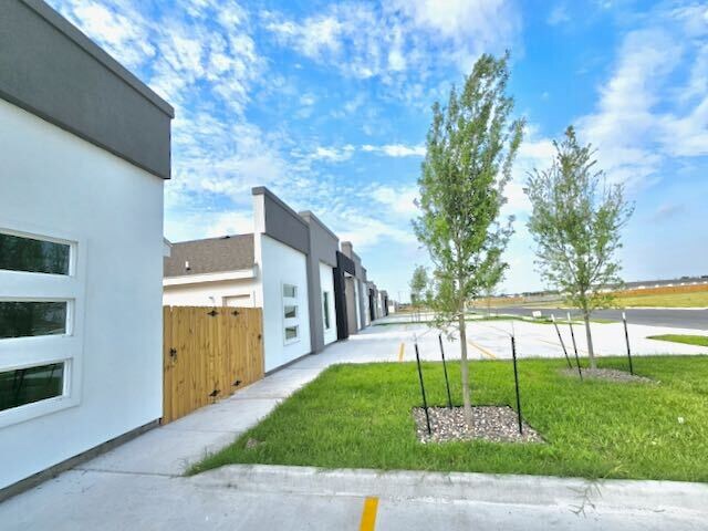
This Property Is For Sale
NEARBY LISTINGS FOR SALE OR LEASE
Property Detail
4701 N 33Rd St
McAllen/Edinburg/Pharr
Las Banderas - Sml
McAllen-Edinburg-Mission, TX
Hidalgo
L3080-00-000-0027-00
Texas
Sfr
0.21 AC
2,386 SF
Downtown McAllen
DEMOGRAPHICS near 4701 N 33Rd St
1 Mile
3 Mile
5 Mile
2024 Total Population
13,081
101,160
225,362
2029 Population
13,431
105,568
238,556
Pop Growth 2024-2029
+ 2.68%
+ 4.36%
+ 5.85%
Average Age
35
36
36
2024 Total Households
3,871
33,945
75,652
HH Growth 2024-2029
+ 2.20%
+ 4.01%
+ 5.71%
Median Household Inc
$64,352
$60,632
$54,433
Avg Household Size
3.20
2.90
2.90
2024 Avg HH Vehicles
2.00
2.00
2.00
Median Home Value
$154,350
$172,411
$160,493
Median Year Built
2000
1994
1997
Nearby Places
Map Layers
Map Styles
 Street
 Aerial
- Restaurants
- Banks
- Shops
- Fitness
- Groceries
PUBLIC TRANSPORTATION
AIRPORT
McAllen International
DRIVE
WALK
Distance
McAllen International
13 min
6.3 mi
Freight Ports
Port of Brownsville
DRIVE
WALK
Distance
Port of Brownsville
75 min
63.2 mi
Nearby Properties
Address
Land Use
TOTAL SIZE
Lot Size
Zoning
Address
Land Use
TOTAL SIZE
Lot Size
Zoning
407,190 SF
11.04 AC
CO
Address
Land Use
TOTAL SIZE
Lot Size
Zoning
357,818 SF
11.10 AC
Address
Land Use
TOTAL SIZE
Lot Size
Zoning
18 SF
82.24 AC
Address
Land Use
TOTAL SIZE
Lot Size
Zoning
263,388 SF
37.48 AC
Address
Land Use
TOTAL SIZE
Lot Size
Zoning
235,545 SF
40.51 AC
Address
Land Use
TOTAL SIZE
Lot Size
Zoning
251,423 SF
27.39 AC
CO
Address
Land Use
TOTAL SIZE
Lot Size
Zoning
128,076 SF
5.01 AC
Address
Land Use
TOTAL SIZE
Lot Size
Zoning
125,254 SF
15 AC
C
Address
Land Use
TOTAL SIZE
Lot Size
Zoning
208,113 SF
22.75 AC
Address
Land Use
TOTAL SIZE
Lot Size
Zoning
173,217 SF
5.58 AC
Address
Land Use
TOTAL SIZE
Lot Size
Zoning
40,248 SF
10.36 AC
Address
Land Use
TOTAL SIZE
Lot Size
Zoning
115,360 SF
4.70 AC
Address
Land Use
TOTAL SIZE
Lot Size
Zoning
16.83 AC
CO
Address
Land Use
TOTAL SIZE
Lot Size
Zoning
92,603 SF
7.10 AC
CO
Address
Land Use
TOTAL SIZE
Lot Size
Zoning
45.87 AC
Address
Land Use
TOTAL SIZE
Lot Size
Zoning
135,878 SF
15.45 AC
Address
Land Use
TOTAL SIZE
Lot Size
Zoning
90,172 SF
8.71 AC
Address
Land Use
TOTAL SIZE
Lot Size
Zoning
1 SF
7.79 AC
Address
Land Use
TOTAL SIZE
Lot Size
Zoning
1 SF
37.01 AC
Address
Land Use
TOTAL SIZE
Lot Size
Zoning
82,724 SF
3.27 AC
Address
Land Use
TOTAL SIZE
Lot Size
Zoning
138,653 SF
22.89 AC
Address
Land Use
TOTAL SIZE
Lot Size
Zoning
95,245 SF
8.92 AC
C-3
Address
Land Use
TOTAL SIZE
Lot Size
Zoning
54,270 SF
29 AC
Address
Land Use
TOTAL SIZE
Lot Size
Zoning
3 SF
14.43 AC
Address
Land Use
TOTAL SIZE
Lot Size
Zoning
174,041 SF
14.66 AC
Address
Land Use
TOTAL SIZE
Lot Size
Zoning
62,624 SF
8.80 AC
Address
Land Use
TOTAL SIZE
Lot Size
Zoning
1 SF
20.84 AC
Address
Land Use
TOTAL SIZE
Lot Size
Zoning
80,082 SF
1.94 AC
Address
Land Use
TOTAL SIZE
Lot Size
Zoning
125,693 SF
11.17 AC
CO
Address
Land Use
TOTAL SIZE
Lot Size
Zoning
70,306 SF
2.83 AC
RS
The World's #1 Commercial Real Estate Marketplace
Connect with us
© 2026 CoStar Group
The information above has been obtained from sources believed reliable. While we do not doubt its accuracy we have not verified it and make no guarantee, warranty or representation about it. It is your responsibility to independently confirm its accuracy and completeness. Any projections, opinions, assumptions, or estimates used are for example only and do not represent the current or future performance of the property. The value of this transaction to you depends on tax and other factors which should be evaluated by your tax, financial, and legal advisors. You and your advisors should conduct a careful, independent investigation of the property to determine to your satisfaction the suitability of the property for your needs.