Property Record
1265 Ben Sawyer Blvd, Mount Pleasant, SC 29464
NEARBY LISTINGS FOR SALE OR LEASE
Property Detail
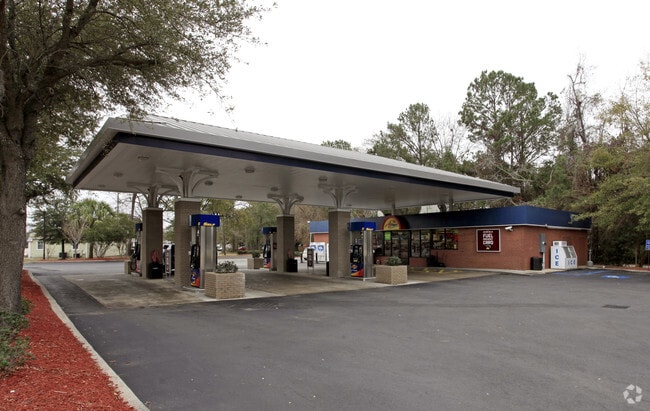
1265 Ben Sawyer Blvd
Charleston-North Charleston, SC
Greenwich
532-07-00-026
SUBDIVISION NAME -GREENWICH DESCRIPTION -LOT 1 SITE NAME -SPEEDWAY
Commercialnec
Charleston
X
South Carolina
45019C0536K
1
2025
0.85 AC
2024
East Islands/Mt Pleasant
004701
Charleston/N Charleston
2,470 SF
DEMOGRAPHICS near 1265 Ben Sawyer Blvd
1 Mile
3 Mile
5 Mile
2024 Total Population
10,106
40,659
82,558
2029 Population
10,870
43,568
88,968
Pop Growth 2024-2029
+ 7.56%
+ 7.15%
+ 7.76%
Average Age
41
43
41
2024 Total Households
4,582
18,063
36,050
HH Growth 2024-2029
+ 7.40%
+ 7.10%
+ 7.74%
Median Household Inc
$94,911
$97,952
$93,974
Avg Household Size
2.20
2.20
2.20
2024 Avg HH Vehicles
2.00
2.00
2.00
Median Home Value
$606,299
$631,141
$645,835
Median Year Built
1980
1989
1988
Nearby Places
Map Layers
Map Styles
 Street
 Aerial
- Restaurants
- Banks
- Shops
- Fitness
- Groceries
PUBLIC TRANSPORTATION
AIRPORT
Charleston AFB/International
DRIVE
WALK
Distance
Charleston AFB/International
29 min
20.3 mi
Freight Ports
Wando Welch Terminal
DRIVE
WALK
Distance
Wando Welch Terminal
9 min
5.1 mi
Nearby Properties
Address
Land Use
TOTAL SIZE
Lot Size
Zoning
Address
Land Use
TOTAL SIZE
Lot Size
Zoning
247,883 SF
16.26 AC
Address
Land Use
TOTAL SIZE
Lot Size
Zoning
2,592 SF
13.64 AC
Address
Land Use
TOTAL SIZE
Lot Size
Zoning
Address
Land Use
TOTAL SIZE
Lot Size
Zoning
39,150 SF
7.76 AC
Address
Land Use
TOTAL SIZE
Lot Size
Zoning
Address
Land Use
TOTAL SIZE
Lot Size
Zoning
85,408 SF
9.39 AC
Address
Land Use
TOTAL SIZE
Lot Size
Zoning
Address
Land Use
TOTAL SIZE
Lot Size
Zoning
1,282 SF
8.42 AC
Address
Land Use
TOTAL SIZE
Lot Size
Zoning
18,316 SF
14.16 AC
Address
Land Use
TOTAL SIZE
Lot Size
Zoning
31,094 SF
5.97 AC
Address
Land Use
TOTAL SIZE
Lot Size
Zoning
12,358 SF
15.08 AC
Address
Land Use
TOTAL SIZE
Lot Size
Zoning
6,572 SF
23.28 AC
Address
Land Use
TOTAL SIZE
Lot Size
Zoning
34,713 SF
13.51 AC
Address
Land Use
TOTAL SIZE
Lot Size
Zoning
Address
Land Use
TOTAL SIZE
Lot Size
Zoning
1,222 SF
13.62 AC
Address
Land Use
TOTAL SIZE
Lot Size
Zoning
37,472 SF
9.04 AC
Address
Land Use
TOTAL SIZE
Lot Size
Zoning
9,993 SF
0.15 AC
LAR3
Address
Land Use
TOTAL SIZE
Lot Size
Zoning
1,872 SF
4.48 AC
Address
Land Use
TOTAL SIZE
Lot Size
Zoning
1,064 SF
20.39 AC
Address
Land Use
TOTAL SIZE
Lot Size
Zoning
1,615 SF
32.59 AC
Address
Land Use
TOTAL SIZE
Lot Size
Zoning
11.29 AC
Address
Land Use
TOTAL SIZE
Lot Size
Zoning
10,165 SF
1.38 AC
Address
Land Use
TOTAL SIZE
Lot Size
Zoning
1,065 SF
1.01 AC
Address
Land Use
TOTAL SIZE
Lot Size
Zoning
Address
Land Use
TOTAL SIZE
Lot Size
Zoning
120,719 SF
7.14 AC
Address
Land Use
TOTAL SIZE
Lot Size
Zoning
648 SF
19.68 AC
Address
Land Use
TOTAL SIZE
Lot Size
Zoning
2.32 AC
Address
Land Use
TOTAL SIZE
Lot Size
Zoning
80,395 SF
15.24 AC
Address
Land Use
TOTAL SIZE
Lot Size
Zoning
2,624 SF
2 AC
Address
Land Use
TOTAL SIZE
Lot Size
Zoning
65,904 SF
3.87 AC
The World's #1 Commercial Real Estate Marketplace
Connect with us
© 2025 CoStar Group
The information above has been obtained from sources believed reliable. While we do not doubt its accuracy we have not verified it and make no guarantee, warranty or representation about it. It is your responsibility to independently confirm its accuracy and completeness. Any projections, opinions, assumptions, or estimates used are for example only and do not represent the current or future performance of the property. The value of this transaction to you depends on tax and other factors which should be evaluated by your tax, financial, and legal advisors. You and your advisors should conduct a careful, independent investigation of the property to determine to your satisfaction the suitability of the property for your needs.