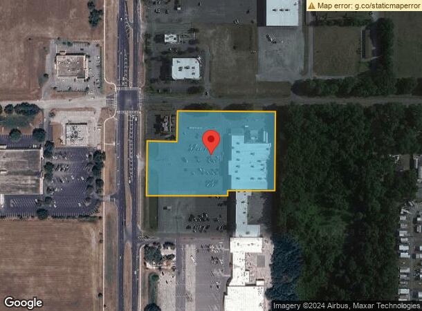
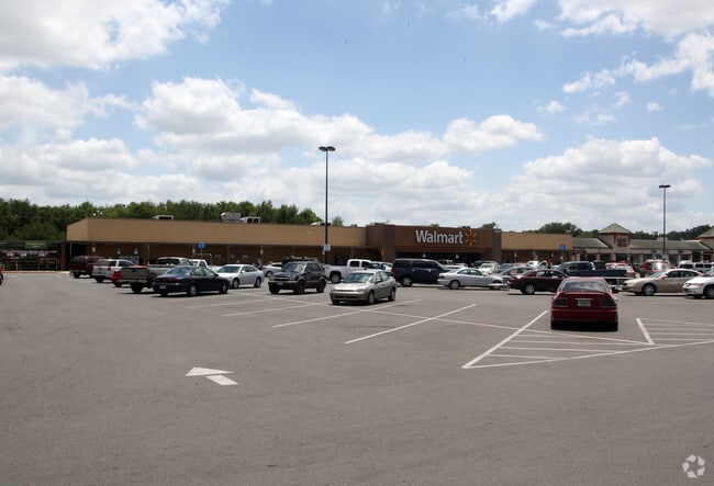
Property Record
12650 Us Highway 301, Dade City, FL 33525

NEARBY LISTINGS FOR SALE OR LEASE
Property Detail
12650 Us Highway 301
Tampa-St. Petersburg-Clearwater, FL
Shopping Center Or Other Site
02-25-21-0000-00600-0040
COM AT INTERSECTION OF ELY R/W LINE OF US 301 & SLY R/W LINE OF MORINGSIDE DR TH N88DEG 22 00E 150.00 FT TO POB TH N88DEG 2200E 490.00 FT TH S01DEG 3700E 395.07 FT TH S88DEG 2300W 235.00 FT TH S01DEG 3700E 26.12 FT TH S88DEG 2300W 405.00 FT TH N01DEG
Departmentstore
Pasco
A
Florida
12101C0285F
4
2024
5.53 AC
2026
Pasco County
032700
Tampa/St Petersburg
43,676 SF
DEMOGRAPHICS near 12650 Us Highway 301
1 Mile
3 Mile
5 Mile
2024 Total Population
2,860
21,026
33,090
2029 Population
3,462
25,517
39,960
Pop Growth 2024-2029
+ 21.05%
+ 21.36%
+ 20.76%
Average Age
43
41
42
2024 Total Households
1,092
7,954
12,372
HH Growth 2024-2029
+ 20.79%
+ 21.28%
+ 21.11%
Median Household Inc
$57,898
$55,382
$57,209
Avg Household Size
2.50
2.50
2.50
2024 Avg HH Vehicles
2.00
2.00
2.00
Median Home Value
$202,250
$180,899
$204,539
Median Year Built
1983
1983
1987
Nearby Places
Map Layers
Map Styles
 Street
 Aerial
- Restaurants
- Banks
- Shops
- Fitness
- Groceries
Nearby Properties
Address
Land Use
TOTAL SIZE
Lot Size
Zoning
Address
Land Use
TOTAL SIZE
Lot Size
Zoning
203,039 SF
41.45 AC
MF1
Address
Land Use
TOTAL SIZE
Lot Size
Zoning
127,340 SF
15.04 AC
AC
Address
Land Use
TOTAL SIZE
Lot Size
Zoning
191,025 SF
27.54 AC
RIO
Address
Land Use
TOTAL SIZE
Lot Size
Zoning
119,784 SF
7.79 AC
RIO
Address
Land Use
TOTAL SIZE
Lot Size
Zoning
80,036 SF
12 AC
C2
Address
Land Use
TOTAL SIZE
Lot Size
Zoning
98,666 SF
19.80 AC
RIO
Address
Land Use
TOTAL SIZE
Lot Size
Zoning
320,071 SF
23.74 AC
PDEC
Address
Land Use
TOTAL SIZE
Lot Size
Zoning
82,689 SF
19.18 AC
RG1
Address
Land Use
TOTAL SIZE
Lot Size
Zoning
76,418 SF
2.78 AC
RIO
Address
Land Use
TOTAL SIZE
Lot Size
Zoning
84,706 SF
13.65 AC
RIO
Address
Land Use
TOTAL SIZE
Lot Size
Zoning
54,371 SF
8.09 AC
CH
Address
Land Use
TOTAL SIZE
Lot Size
Zoning
16,994 SF
2.40 AC
CG
Address
Land Use
TOTAL SIZE
Lot Size
Zoning
111,677 SF
10.40 AC
CG
Address
Land Use
TOTAL SIZE
Lot Size
Zoning
33,580 SF
6.09 AC
RIO
Address
Land Use
TOTAL SIZE
Lot Size
Zoning
88,358 SF
36.68 AC
OUA
Address
Land Use
TOTAL SIZE
Lot Size
Zoning
86,138 SF
6.62 AC
CG
Address
Land Use
TOTAL SIZE
Lot Size
Zoning
37,368 SF
10.82 AC
CG
Address
Land Use
TOTAL SIZE
Lot Size
Zoning
76,818 SF
15 AC
AC
Address
Land Use
TOTAL SIZE
Lot Size
Zoning
64,520 SF
11.65 AC
I2
Address
Land Use
TOTAL SIZE
Lot Size
Zoning
65,354 SF
15 AC
RIO
Address
Land Use
TOTAL SIZE
Lot Size
Zoning
26,520 SF
4.42 AC
CG
Address
Land Use
TOTAL SIZE
Lot Size
Zoning
95,673 SF
7.51 AC
PDH2
Address
Land Use
TOTAL SIZE
Lot Size
Zoning
36,518 SF
2.77 AC
CG
Address
Land Use
TOTAL SIZE
Lot Size
Zoning
131,580 SF
3.84 AC
PDEC
Address
Land Use
TOTAL SIZE
Lot Size
Zoning
44,210 SF
7.10 AC
C2
Address
Land Use
TOTAL SIZE
Lot Size
Zoning
32,530 SF
33 AC
RIO
Address
Land Use
TOTAL SIZE
Lot Size
Zoning
35,904 SF
5.19 AC
RS1
Address
Land Use
TOTAL SIZE
Lot Size
Zoning
130,200 SF
0.74 AC
CBD
Address
Land Use
TOTAL SIZE
Lot Size
Zoning
112,952 SF
13.03 AC
MF1
Address
Land Use
TOTAL SIZE
Lot Size
Zoning
41,400 SF
4.91 AC
PDEC
The World's #1 Commercial Real Estate Marketplace
Connect with us
© 2026 CoStar Group
The information above has been obtained from sources believed reliable. While we do not doubt its accuracy we have not verified it and make no guarantee, warranty or representation about it. It is your responsibility to independently confirm its accuracy and completeness. Any projections, opinions, assumptions, or estimates used are for example only and do not represent the current or future performance of the property. The value of this transaction to you depends on tax and other factors which should be evaluated by your tax, financial, and legal advisors. You and your advisors should conduct a careful, independent investigation of the property to determine to your satisfaction the suitability of the property for your needs.