Property Record
12655 Cumberland Dr, Papillion, NE 68138

NEARBY LISTINGS FOR SALE OR LEASE
-
-
-
-
-
-
S 158th St. & Gold Coast Rd. - Lot 4, Steel Ridge South
Omaha, NE 68138
$6,450,000
19.60 AC Lots
Land
-
-
View all Papillion listings for sale on LoopNet.com
Property Detail
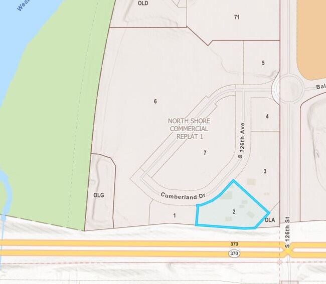
12655 Cumberland Dr
Omaha-Council Bluffs, NE-IA
North Shore Commercial Replat 1
011606081
LOT 2 NORTH SHORE COMMERCIAL REPLAT 1 (1.677 AC)
Commercialnec
Sarpy
X
Nebraska
31153C0063H
2
2024
1.68 AC
2025
South Central
010629
Omaha/Council Bluffs
7,673 SF
DEMOGRAPHICS near 12655 Cumberland Dr
1 Mile
3 Mile
5 Mile
2024 Total Population
2,977
22,640
128,051
2029 Population
3,266
24,440
135,108
Pop Growth 2024-2029
+ 9.71%
+ 7.95%
+ 5.51%
Average Age
36
36
38
2024 Total Households
1,199
8,495
49,261
HH Growth 2024-2029
+ 10.09%
+ 8.26%
+ 5.48%
Median Household Inc
$93,598
$93,183
$85,893
Avg Household Size
2.50
2.60
2.50
2024 Avg HH Vehicles
2.00
2.00
2.00
Median Home Value
$472,097
$271,901
$254,851
Median Year Built
2010
2000
1990
Nearby Places
Map Layers
Map Styles
 Street
 Aerial
- Restaurants
- Banks
- Shops
- Fitness
- Groceries
PUBLIC TRANSPORTATION
AIRPORT
Eppley Airfield
DRIVE
WALK
Distance
Eppley Airfield
33 min
21.8 mi
Freight Ports
Tulsa Port Of Catoosa
DRIVE
WALK
Distance
Tulsa Port Of Catoosa
466 min
419.2 mi
Nearby Properties
Address
Land Use
TOTAL SIZE
Lot Size
Zoning
Address
Land Use
TOTAL SIZE
Lot Size
Zoning
181,712 SF
131.75 AC
Address
Land Use
TOTAL SIZE
Lot Size
Zoning
94.11 AC
Address
Land Use
TOTAL SIZE
Lot Size
Zoning
1,831 SF
173.14 AC
Address
Land Use
TOTAL SIZE
Lot Size
Zoning
2,400 SF
21.27 AC
Address
Land Use
TOTAL SIZE
Lot Size
Zoning
51.65 AC
Address
Land Use
TOTAL SIZE
Lot Size
Zoning
3,654 SF
39.62 AC
Address
Land Use
TOTAL SIZE
Lot Size
Zoning
543,301 SF
2.30 AC
IL
Address
Land Use
TOTAL SIZE
Lot Size
Zoning
28,820 SF
16.81 AC
Address
Land Use
TOTAL SIZE
Lot Size
Zoning
599,779 SF
46.87 AC
I1
Address
Land Use
TOTAL SIZE
Lot Size
Zoning
48.50 AC
Address
Land Use
TOTAL SIZE
Lot Size
Zoning
315,685 SF
21.57 AC
RG10
Address
Land Use
TOTAL SIZE
Lot Size
Zoning
56,174 SF
8.65 AC
Address
Land Use
TOTAL SIZE
Lot Size
Zoning
252,985 SF
6.53 AC
Address
Land Use
TOTAL SIZE
Lot Size
Zoning
317,277 SF
20.12 AC
Address
Land Use
TOTAL SIZE
Lot Size
Zoning
9,600 SF
2.07 AC
IL
Address
Land Use
TOTAL SIZE
Lot Size
Zoning
8.10 AC
Address
Land Use
TOTAL SIZE
Lot Size
Zoning
46,886 SF
19.29 AC
Address
Land Use
TOTAL SIZE
Lot Size
Zoning
23.99 AC
Address
Land Use
TOTAL SIZE
Lot Size
Zoning
334,533 SF
23.32 AC
Address
Land Use
TOTAL SIZE
Lot Size
Zoning
17.40 AC
Address
Land Use
TOTAL SIZE
Lot Size
Zoning
22.05 AC
Address
Land Use
TOTAL SIZE
Lot Size
Zoning
85,632 SF
5.69 AC
Address
Land Use
TOTAL SIZE
Lot Size
Zoning
24,294 SF
25.79 AC
Address
Land Use
TOTAL SIZE
Lot Size
Zoning
183,184 SF
20.66 AC
Address
Land Use
TOTAL SIZE
Lot Size
Zoning
56,150 SF
28.48 AC
Address
Land Use
TOTAL SIZE
Lot Size
Zoning
240,122 SF
10.16 AC
Address
Land Use
TOTAL SIZE
Lot Size
Zoning
210,585 SF
142.28 AC
I2
Address
Land Use
TOTAL SIZE
Lot Size
Zoning
16.57 AC
Address
Land Use
TOTAL SIZE
Lot Size
Zoning
250,999 SF
17.10 AC
Address
Land Use
TOTAL SIZE
Lot Size
Zoning
250,999 SF
15.44 AC
The World's #1 Commercial Real Estate Marketplace
Connect with us
© 2026 CoStar Group
The information above has been obtained from sources believed reliable. While we do not doubt its accuracy we have not verified it and make no guarantee, warranty or representation about it. It is your responsibility to independently confirm its accuracy and completeness. Any projections, opinions, assumptions, or estimates used are for example only and do not represent the current or future performance of the property. The value of this transaction to you depends on tax and other factors which should be evaluated by your tax, financial, and legal advisors. You and your advisors should conduct a careful, independent investigation of the property to determine to your satisfaction the suitability of the property for your needs.