Property Record
1266 Broadway, Raynham, MA 02767
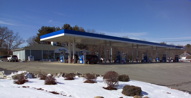


Property Detail
1266 Broadway
RAYN-000003-000382
BRISTOL
Commercialnec
Massachusetts
B and X Area of moderate flood hazard, usually the area between the limits of the 100-year and 500-year floods.
1.91 AC
2024
Attleboro/New Bedford
2025
Boston
612100
Providence-Warwick, RI-MA
NEARBY LISTINGS FOR SALE OR LEASE
DEMOGRAPHICS near 1266 Broadway
1 mile
3 mile
5 mile
2025 Total Population
2,645
17,021
69,040
2030 Population
2,702
17,408
70,329
Pop Growth 2025-2030
+ 2.16%
+ 2.27%
+ 1.87%
Average Age
43
43
42
2025 Total Households
1,003
6,587
26,811
HH Growth 2025-2030
+ 2.19%
+ 2.26%
+ 1.88%
Median Household Inc
$92,835
$97,495
$94,323
Avg Household Size
2.60
2.50
2.50
2025 Avg HH Vehicles
2.00
2.00
2.00
Median Home Value
$606,190
$544,419
$495,089
Median Year Built
1983
1978
1972
Nearby Places
Map Layers
Map Styles
 Street
 Aerial
Transit
 Traffic
 Biking
Places
Listings with unknown addresses are not visible on the map
- Restaurants
- Banks
- Shops
- Fitness
- Groceries
PUBLIC TRANSPORTATION
COMMUTER RAIL
Bridgewater (Middleborough/Lakeville Line - Massachusetts Bay Transportation Authority Commuter Rail (Purple Line))
Drive
Walk
Distance
Bridgewater (Middleborough/Lakeville Line - Massachusetts Bay Transportation Authority Commuter Rail (Purple Line))
17 min
7.2 mi
Campello (Middleborough/Lakeville Line - Massachusetts Bay Transportation Authority Commuter Rail (Purple Line))
Drive
Walk
Distance
Campello (Middleborough/Lakeville Line - Massachusetts Bay Transportation Authority Commuter Rail (Purple Line))
17 min
9.1 mi
AIRPORT
Rhode Island Tf Green International
Drive
Walk
Distance
Rhode Island Tf Green International
53 min
29.8 mi
General Edward Lawrence Logan International
Drive
Walk
Distance
General Edward Lawrence Logan International
49 min
34.4 mi
Nearby Properties
Address
Land Use
TOTAL SIZE
Lot Size
Zoning
Address
Land Use
TOTAL SIZE
Lot Size
Zoning
0.78 AC
Address
Land Use
TOTAL SIZE
Lot Size
Zoning
24.34 AC
Address
Land Use
TOTAL SIZE
Lot Size
Zoning
87,591 SF
19.83 AC
Address
Land Use
TOTAL SIZE
Lot Size
Zoning
149,234 SF
40.69 AC
Address
Land Use
TOTAL SIZE
Lot Size
Zoning
100,000 SF
24.80 AC
Address
Land Use
TOTAL SIZE
Lot Size
Zoning
109,960 SF
28.02 AC
Address
Land Use
TOTAL SIZE
Lot Size
Zoning
104,207 SF
27.78 AC
Address
Land Use
TOTAL SIZE
Lot Size
Zoning
200,000 SF
14.56 AC
INDUST
Address
Land Use
TOTAL SIZE
Lot Size
Zoning
32.93 AC
BIZDIS
Address
Land Use
TOTAL SIZE
Lot Size
Zoning
8,000 SF
22.31 AC
Address
Land Use
TOTAL SIZE
Lot Size
Zoning
62,555 SF
5.09 AC
OFFDIS
Address
Land Use
TOTAL SIZE
Lot Size
Zoning
76,332 SF
6.20 AC
Address
Land Use
TOTAL SIZE
Lot Size
Zoning
152,070 SF
26.26 AC
Address
Land Use
TOTAL SIZE
Lot Size
Zoning
79,144 SF
5.30 AC
Address
Land Use
TOTAL SIZE
Lot Size
Zoning
154,499 SF
11.30 AC
Address
Land Use
TOTAL SIZE
Lot Size
Zoning
61,360 SF
5.10 AC
Address
Land Use
TOTAL SIZE
Lot Size
Zoning
16.06 AC
Address
Land Use
TOTAL SIZE
Lot Size
Zoning
76,111 SF
14.50 AC
Address
Land Use
TOTAL SIZE
Lot Size
Zoning
20.81 AC
Address
Land Use
TOTAL SIZE
Lot Size
Zoning
12,396 SF
4.66 AC
Address
Land Use
TOTAL SIZE
Lot Size
Zoning
29.65 AC
Address
Land Use
TOTAL SIZE
Lot Size
Zoning
10.92 AC
Address
Land Use
TOTAL SIZE
Lot Size
Zoning
40,000 SF
9.27 AC
Address
Land Use
TOTAL SIZE
Lot Size
Zoning
59,608 SF
5.76 AC
Address
Land Use
TOTAL SIZE
Lot Size
Zoning
18,400 SF
7.67 AC
Address
Land Use
TOTAL SIZE
Lot Size
Zoning
67,540 SF
5.51 AC
Address
Land Use
TOTAL SIZE
Lot Size
Zoning
3.14 AC
Address
Land Use
TOTAL SIZE
Lot Size
Zoning
6.89 AC
INDUST
Address
Land Use
TOTAL SIZE
Lot Size
Zoning
67,600 SF
14.03 AC
Address
Land Use
TOTAL SIZE
Lot Size
Zoning
58,606 SF
6.77 AC
The World's #1 Commercial Real Estate Marketplace
Connect with us
© 2026 CoStar Group
The information above has been obtained from sources believed reliable. While we do not doubt its accuracy we have not verified it and make no guarantee, warranty or representation about it. It is your responsibility to independently confirm its accuracy and completeness. Any projections, opinions, assumptions, or estimates used are for example only and do not represent the current or future performance of the property. The value of this transaction to you depends on tax and other factors which should be evaluated by your tax, financial, and legal advisors. You and your advisors should conduct a careful, independent investigation of the property to determine to your satisfaction the suitability of the property for your needs.