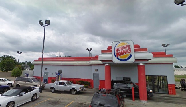
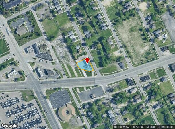
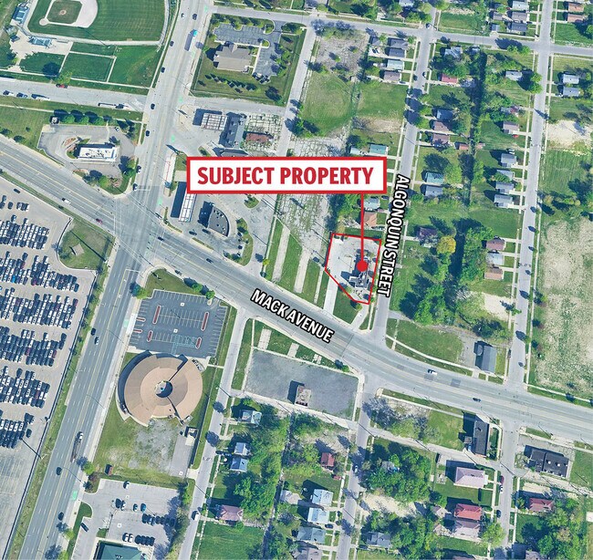
Property Record
12661 Mack Ave, Detroit, MI 48215
NEARBY LISTINGS FOR SALE OR LEASE
Property Detail
12661 Mack Ave
21-00-127-90-02L
Daniel J Campaus
Restaurantdrivein
N MACK 358 THRU 360 EXC MACK AVE AS WD DANIEL J CAMPAUS SUB L42 P19 PLATS, W C R 21/649 107.21 IRREG
X
Wayne
26163C0140F
Michigan
2024
0.31 AC
2025
Detroit E of Woodward
502700
Detroit
1,616 SF
Detroit-Warren-Dearborn, MI
DEMOGRAPHICS near 12661 Mack Ave
1 Mile
3 Mile
5 Mile
2024 Total Population
8,973
120,729
266,608
2029 Population
9,290
121,856
265,076
Pop Growth 2024-2029
+ 3.53%
+ 0.93%
(0.57%)
Average Age
39
40
38
2024 Total Households
3,555
48,653
104,365
HH Growth 2024-2029
+ 3.80%
+ 0.80%
(0.68%)
Median Household Inc
$23,226
$39,550
$42,785
Avg Household Size
2.30
2.40
2.50
2024 Avg HH Vehicles
1.00
1.00
1.00
Median Home Value
$88,414
$100,531
$108,467
Median Year Built
1954
1948
1950
Nearby Places
- Restaurants
- Banks
- Shops
- Fitness
- Groceries
PUBLIC TRANSPORTATION
COMMUTER RAIL
DRIVE
WALK
Distance
13 min
6.8 mi
AIRPORT
Windsor International
DRIVE
WALK
Distance
Windsor International
39 min
18.0 mi
Detroit Metro Wayne County
DRIVE
WALK
Distance
Detroit Metro Wayne County
41 min
27.7 mi
Freight Ports
DRIVE
WALK
Distance
87 min
68.5 mi
SALE & LEASE HISTORY
LISTING DATE
SALE/LEASE

Nov 10, 2023
For Sale
Jul 21, 2023
For Sale
Dec 03, 2025
For Sale
Nearby Properties
Address
Land Use
TOTAL SIZE
Lot Size
Zoning
Address
Land Use
TOTAL SIZE
Lot Size
Zoning
2,958,207 SF
277.38 AC
M4
Address
Land Use
TOTAL SIZE
Lot Size
Zoning
2,005,073 SF
108.66 AC
M4
Address
Land Use
TOTAL SIZE
Lot Size
Zoning
461,840 SF
4.78 AC
R6
Address
Land Use
TOTAL SIZE
Lot Size
Zoning
384,217 SF
3.40 AC
R6
Address
Land Use
TOTAL SIZE
Lot Size
Zoning
381,920 SF
0.68 AC
R6
Address
Land Use
TOTAL SIZE
Lot Size
Zoning
929,400 SF
52.48 AC
M4
Address
Land Use
TOTAL SIZE
Lot Size
Zoning
482,649 SF
M4
Address
Land Use
TOTAL SIZE
Lot Size
Zoning
648,928 SF
5.46 AC
R6
Address
Land Use
TOTAL SIZE
Lot Size
Zoning
298,117 SF
15.97 AC
PD
Address
Land Use
TOTAL SIZE
Lot Size
Zoning
267,185 SF
13.08 AC
PD
Address
Land Use
TOTAL SIZE
Lot Size
Zoning
165,834 SF
6.77 AC
R6
Address
Land Use
TOTAL SIZE
Lot Size
Zoning
144,578 SF
7.10 AC
PD
Address
Land Use
TOTAL SIZE
Lot Size
Zoning
300,000 SF
0.29 AC
M4
Address
Land Use
TOTAL SIZE
Lot Size
Zoning
136,576 SF
8.23 AC
R6
Address
Land Use
TOTAL SIZE
Lot Size
Zoning
57.16 AC
M4
Address
Land Use
TOTAL SIZE
Lot Size
Zoning
93,296 SF
1.05 AC
C-2
Address
Land Use
TOTAL SIZE
Lot Size
Zoning
358,327 SF
M4
Address
Land Use
TOTAL SIZE
Lot Size
Zoning
161,250 SF
0.50 AC
R2
Address
Land Use
TOTAL SIZE
Lot Size
Zoning
302,305 SF
M4
Address
Land Use
TOTAL SIZE
Lot Size
Zoning
41,000 SF
C-1
Address
Land Use
TOTAL SIZE
Lot Size
Zoning
122,600 SF
0.07 AC
B4
Address
Land Use
TOTAL SIZE
Lot Size
Zoning
89,897 SF
2.23 AC
Address
Land Use
TOTAL SIZE
Lot Size
Zoning
129,260 SF
3 AC
B4
Address
Land Use
TOTAL SIZE
Lot Size
Zoning
88,592 SF
0.46 AC
R2
Address
Land Use
TOTAL SIZE
Lot Size
Zoning
72,940 SF
83.37 AC
M4
Address
Land Use
TOTAL SIZE
Lot Size
Zoning
52,452 SF
0.54 AC
Address
Land Use
TOTAL SIZE
Lot Size
Zoning
93,850 SF
6.56 AC
Address
Land Use
TOTAL SIZE
Lot Size
Zoning
88,695 SF
6.53 AC
PD
Address
Land Use
TOTAL SIZE
Lot Size
Zoning
115,839 SF
8.54 AC
M4
Address
Land Use
TOTAL SIZE
Lot Size
Zoning
105,847 SF
2.28 AC
R5
The World's #1 Commercial Real Estate Marketplace
Connect with us
© 2025 CoStar Group
The information above has been obtained from sources believed reliable. While we do not doubt its accuracy we have not verified it and make no guarantee, warranty or representation about it. It is your responsibility to independently confirm its accuracy and completeness. Any projections, opinions, assumptions, or estimates used are for example only and do not represent the current or future performance of the property. The value of this transaction to you depends on tax and other factors which should be evaluated by your tax, financial, and legal advisors. You and your advisors should conduct a careful, independent investigation of the property to determine to your satisfaction the suitability of the property for your needs.