Property Record
12664 Us Highway 98 W, Miramar Beach, FL 32550

NEARBY LISTINGS FOR SALE OR LEASE
-
-
View all Miramar Beach listings for sale on LoopNet.com
Property Detail
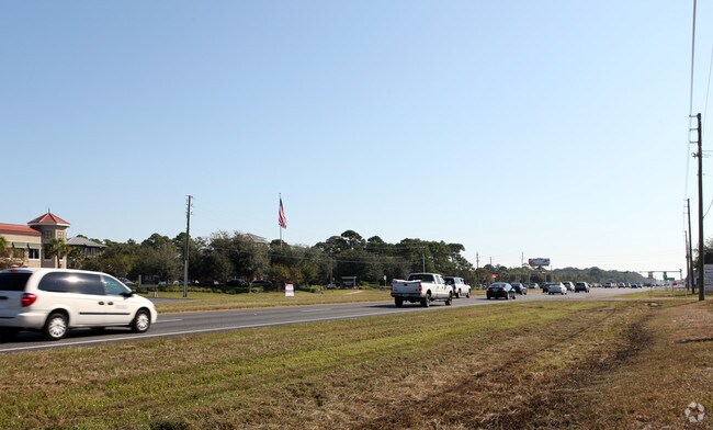
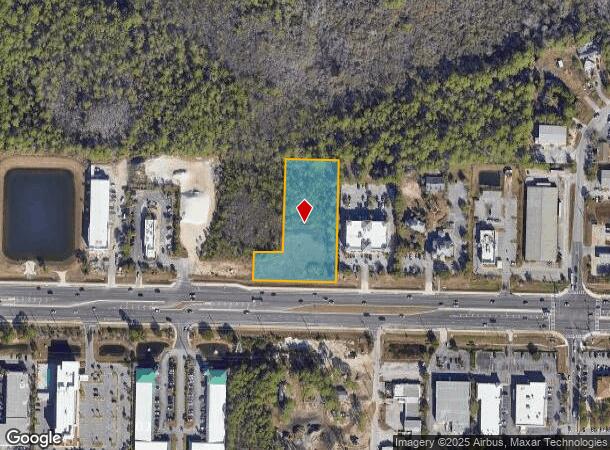
12664 Us Highway 98 W
Crestview-Fort Walton Beach-Destin, FL
As Recd In Or
30-2S-21-42000-001-0010
COM SE/C OF NE1/4 SEC 30-2S-21W, FOLLOW EL INE OF NE1/4 OF SEC 30, CONT N 02 DEG 0052E 299.82FT TO PT ON NLY ROW LINE OF US HWY 98, CONT ALG SAID ROW LINE N 87 DEG 4726W 800.00FT TO POB; CONT N 87 DEG 4726W 297.46FT, DPRT SAID ROW LINE N 02 DEG 1234E
Commercialacreage
Walton
A
Florida
12091C0494J
10
2025
2.02 AC
2025
Fort Walton Beach
950608
Other Market Areas
DEMOGRAPHICS near 12664 Us Highway 98 W
1 Mile
3 Mile
5 Mile
2024 Total Population
4,687
16,524
31,199
2029 Population
6,150
20,601
38,443
Pop Growth 2024-2029
+ 31.21%
+ 24.67%
+ 23.22%
Average Age
51
50
48
2024 Total Households
2,325
7,932
14,565
HH Growth 2024-2029
+ 32.26%
+ 25.88%
+ 24.13%
Median Household Inc
$61,485
$79,916
$85,251
Avg Household Size
2.00
2.10
2.10
2024 Avg HH Vehicles
2.00
2.00
2.00
Median Home Value
$487,351
$488,528
$534,764
Median Year Built
1998
1998
2000
Nearby Places
- Restaurants
- Banks
- Shops
- Fitness
- Groceries
PUBLIC TRANSPORTATION
AIRPORT
Eglin AFB/Destin-Ft Walton Beach
DRIVE
WALK
Distance
Eglin AFB/Destin-Ft Walton Beach
49 min
20.4 mi
Freight Ports
Port of Panama City
DRIVE
WALK
Distance
Port of Panama City
66 min
43.8 mi
Nearby Properties
Address
Land Use
TOTAL SIZE
Lot Size
Zoning
Address
Land Use
TOTAL SIZE
Lot Size
Zoning
429,135 SF
23.38 AC
HWY 98
Address
Land Use
TOTAL SIZE
Lot Size
Zoning
619,795 SF
47.80 AC
Address
Land Use
TOTAL SIZE
Lot Size
Zoning
320,141 SF
16 AC
Address
Land Use
TOTAL SIZE
Lot Size
Zoning
110,181 SF
3.48 AC
Address
Land Use
TOTAL SIZE
Lot Size
Zoning
5.19 AC
GULFFR
Address
Land Use
TOTAL SIZE
Lot Size
Zoning
138,905 SF
4.01 AC
Address
Land Use
TOTAL SIZE
Lot Size
Zoning
19,401 SF
6.66 AC
Address
Land Use
TOTAL SIZE
Lot Size
Zoning
118,963 SF
7.58 AC
Address
Land Use
TOTAL SIZE
Lot Size
Zoning
74,662 SF
6.02 AC
HWY 98
Address
Land Use
TOTAL SIZE
Lot Size
Zoning
223,790 SF
20.75 AC
Address
Land Use
TOTAL SIZE
Lot Size
Zoning
195,622 SF
17.68 AC
Address
Land Use
TOTAL SIZE
Lot Size
Zoning
65,340 SF
1.01 AC
CCMU
Address
Land Use
TOTAL SIZE
Lot Size
Zoning
66,001 SF
1.25 AC
HWY 98
Address
Land Use
TOTAL SIZE
Lot Size
Zoning
28,327 SF
1.45 AC
Address
Land Use
TOTAL SIZE
Lot Size
Zoning
113,053 SF
7.25 AC
Address
Land Use
TOTAL SIZE
Lot Size
Zoning
1.81 AC
GULFFR
Address
Land Use
TOTAL SIZE
Lot Size
Zoning
123,120 SF
4.11 AC
HWY 98
Address
Land Use
TOTAL SIZE
Lot Size
Zoning
201,131 SF
11.29 AC
Address
Land Use
TOTAL SIZE
Lot Size
Zoning
7,416 SF
25.45 AC
HWY 98
Address
Land Use
TOTAL SIZE
Lot Size
Zoning
74,803 SF
6.97 AC
Address
Land Use
TOTAL SIZE
Lot Size
Zoning
154,725 SF
15.69 AC
Address
Land Use
TOTAL SIZE
Lot Size
Zoning
19,864 SF
1.50 AC
Address
Land Use
TOTAL SIZE
Lot Size
Zoning
22.80 AC
Address
Land Use
TOTAL SIZE
Lot Size
Zoning
50,665 SF
5.47 AC
Address
Land Use
TOTAL SIZE
Lot Size
Zoning
89,369 SF
6.54 AC
HWY 98
Address
Land Use
TOTAL SIZE
Lot Size
Zoning
69,744 SF
4.12 AC
Address
Land Use
TOTAL SIZE
Lot Size
Zoning
44,504 SF
1.84 AC
HWY 98
Address
Land Use
TOTAL SIZE
Lot Size
Zoning
36,414 SF
2.18 AC
Address
Land Use
TOTAL SIZE
Lot Size
Zoning
8,086 SF
104.35 AC
HWY 98
Address
Land Use
TOTAL SIZE
Lot Size
Zoning
18,480 SF
1.50 AC
HWY 98
The World's #1 Commercial Real Estate Marketplace
Connect with us
© 2025 CoStar Group
The information above has been obtained from sources believed reliable. While we do not doubt its accuracy we have not verified it and make no guarantee, warranty or representation about it. It is your responsibility to independently confirm its accuracy and completeness. Any projections, opinions, assumptions, or estimates used are for example only and do not represent the current or future performance of the property. The value of this transaction to you depends on tax and other factors which should be evaluated by your tax, financial, and legal advisors. You and your advisors should conduct a careful, independent investigation of the property to determine to your satisfaction the suitability of the property for your needs.