Property Record
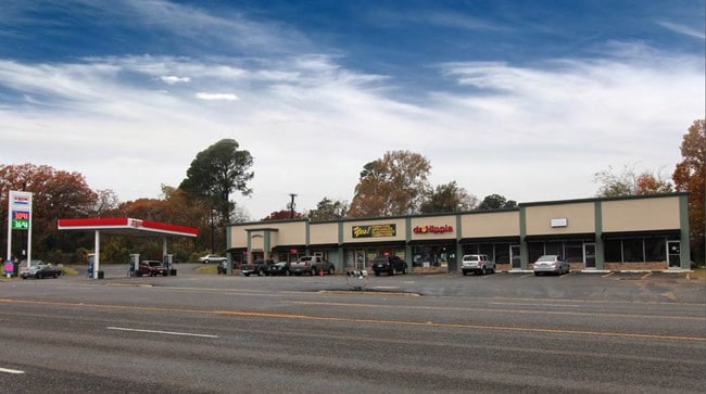
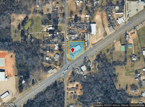
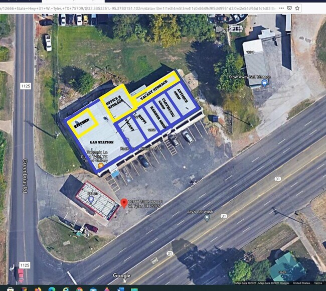
12666 State Highway 31 W, Tyler, TX 75709
NEARBY LISTINGS FOR SALE OR LEASE
Property Detail
12666 State Highway 31 W
Tyler, TX
A0478 E Holland
1-00000-0478-00-022030
ABST A0478 E HOLLANDTRACT 22C
Storebuilding
Smith
X
Texas
48423C0350D
22c
2024
1.12 AC
2025
Tyler
001607
Other Market Areas
7,160 SF
DEMOGRAPHICS near 12666 State Highway 31 W
1 mile
3 mile
5 mile
2024 Total Population
1,590
13,701
59,980
2029 Population
1,735
14,939
65,340
Pop Growth 2024-2029
+ 9.12%
+ 9.04%
+ 8.94%
Average Age
40
38
38
2024 Total Households
615
5,196
23,052
HH Growth 2024-2029
+ 8.46%
+ 8.39%
+ 8.41%
Median Household Inc
$74,077
$56,672
$50,993
Avg Household Size
2.50
2.50
2.40
2024 Avg HH Vehicles
2.00
2.00
2.00
Median Home Value
$167,207
$146,557
$156,916
Median Year Built
1977
1978
1974
Nearby Places
Map Layers
Map Styles
 Street
 Aerial
Transit
 Traffic
 Biking
Places
Listings with unknown addresses are not visible on the map
- Restaurants
- Banks
- Shops
- Fitness
- Groceries
PUBLIC TRANSPORTATION
AIRPORT
Tyler Pounds Regional
Drive
Walk
Distance
Tyler Pounds Regional
11 min
4.9 mi
SALE & LEASE HISTORY
LISTING DATE
SALE/LEASE

Sep 09, 2019
For Sale
Mar 08, 2018
For Sale
Jun 08, 2020
For Sale
Feb 22, 2021
For Sale
Apr 15, 2025
For Sale
Nearby Properties
Address
Land Use
TOTAL SIZE
Lot Size
Zoning
Address
Land Use
TOTAL SIZE
Lot Size
Zoning
11,332 SF
22.07 AC
PMF
Address
Land Use
TOTAL SIZE
Lot Size
Zoning
24.83 AC
Address
Land Use
TOTAL SIZE
Lot Size
Zoning
84,560 SF
15.70 AC
M1
Address
Land Use
TOTAL SIZE
Lot Size
Zoning
187.64 AC
R1A
Address
Land Use
TOTAL SIZE
Lot Size
Zoning
311.96 AC
Address
Land Use
TOTAL SIZE
Lot Size
Zoning
237,916 SF
11.17 AC
PMF
Address
Land Use
TOTAL SIZE
Lot Size
Zoning
126.94 AC
Address
Land Use
TOTAL SIZE
Lot Size
Zoning
3,806 SF
18.86 AC
RMF
Address
Land Use
TOTAL SIZE
Lot Size
Zoning
63 AC
R1A
Address
Land Use
TOTAL SIZE
Lot Size
Zoning
22.85 AC
Address
Land Use
TOTAL SIZE
Lot Size
Zoning
Address
Land Use
TOTAL SIZE
Lot Size
Zoning
2,802 SF
14 AC
RMF
Address
Land Use
TOTAL SIZE
Lot Size
Zoning
14.16 AC
Address
Land Use
TOTAL SIZE
Lot Size
Zoning
45,114 SF
30.60 AC
Address
Land Use
TOTAL SIZE
Lot Size
Zoning
80,070 SF
9.04 AC
Address
Land Use
TOTAL SIZE
Lot Size
Zoning
205,196 SF
25.19 AC
C2
Address
Land Use
TOTAL SIZE
Lot Size
Zoning
85,804 SF
8.69 AC
M1
Address
Land Use
TOTAL SIZE
Lot Size
Zoning
25.57 AC
Address
Land Use
TOTAL SIZE
Lot Size
Zoning
60,956 SF
8.31 AC
M1
Address
Land Use
TOTAL SIZE
Lot Size
Zoning
302,618 SF
27.95 AC
M1
Address
Land Use
TOTAL SIZE
Lot Size
Zoning
60,328 SF
8 AC
M1
Address
Land Use
TOTAL SIZE
Lot Size
Zoning
3,096 SF
13.97 AC
M1
Address
Land Use
TOTAL SIZE
Lot Size
Zoning
239,900 SF
52.09 AC
Address
Land Use
TOTAL SIZE
Lot Size
Zoning
4,496 SF
6.66 AC
Address
Land Use
TOTAL SIZE
Lot Size
Zoning
34,637 SF
149.75 AC
R1A
Address
Land Use
TOTAL SIZE
Lot Size
Zoning
135,792 SF
12.05 AC
C1
Address
Land Use
TOTAL SIZE
Lot Size
Zoning
136,482 SF
12.22 AC
C2
Address
Land Use
TOTAL SIZE
Lot Size
Zoning
18,000 SF
11.70 AC
Address
Land Use
TOTAL SIZE
Lot Size
Zoning
1,868 SF
2.24 AC
Address
Land Use
TOTAL SIZE
Lot Size
Zoning
9,135 SF
11.58 AC
M1
The World's #1 Commercial Real Estate Marketplace
Connect with us
© 2026 CoStar Group
The information above has been obtained from sources believed reliable. While we do not doubt its accuracy we have not verified it and make no guarantee, warranty or representation about it. It is your responsibility to independently confirm its accuracy and completeness. Any projections, opinions, assumptions, or estimates used are for example only and do not represent the current or future performance of the property. The value of this transaction to you depends on tax and other factors which should be evaluated by your tax, financial, and legal advisors. You and your advisors should conduct a careful, independent investigation of the property to determine to your satisfaction the suitability of the property for your needs.