Property Record
12688 S Us Highway 301 S, Starke, FL 32091
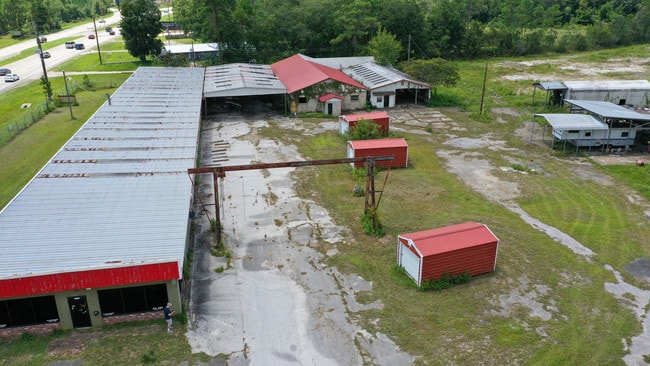
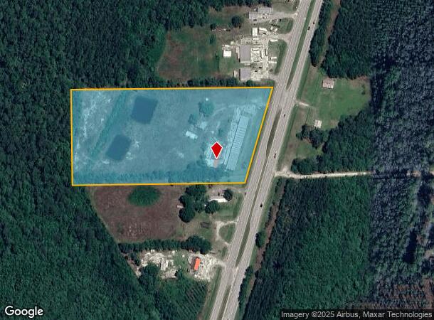
This Property Is For Sale
NEARBY LISTINGS FOR SALE OR LEASE
-
-
View all Starke listings for sale on LoopNet.com
Property Detail
12688 S Us Highway 301 S
Lightindustrial
7 7S 22 COM SW COR OF E1/2 OF SE1/4 OF SW1/4. N481 TO POB. N431.5, E973.95 TO W R/W SR-200, RUN S16*06W 449.8, W845.5 TO POB. EX: R/W
A
Bradford
12007C0195F
Florida
2025
9.20 AC
2025
Florida Central North Area
000302
Other Market Areas
21,693 SF
04759-0-00000
DEMOGRAPHICS near 12688 S Us Highway 301 S
1 Mile
3 Mile
5 Mile
2024 Total Population
288
3,022
11,353
2029 Population
300
3,139
11,842
Pop Growth 2024-2029
+ 4.17%
+ 3.87%
+ 4.31%
Average Age
42
42
41
2024 Total Households
111
1,162
4,345
HH Growth 2024-2029
+ 2.70%
+ 2.93%
+ 3.45%
Median Household Inc
$44,614
$43,949
$45,099
Avg Household Size
2.50
2.50
2.50
2024 Avg HH Vehicles
2.00
2.00
2.00
Median Home Value
$110,417
$126,877
$124,401
Median Year Built
1987
1986
1983
Nearby Places
Map Layers
Map Styles
 Street
 Aerial
- Restaurants
- Banks
- Shops
- Fitness
- Groceries
PUBLIC TRANSPORTATION
AIRPORT
Gainesville Regional
DRIVE
WALK
Distance
Gainesville Regional
29 min
19.6 mi
Freight Ports
Jacksonville Port
DRIVE
WALK
Distance
Jacksonville Port
68 min
53.5 mi
Nearby Properties
Address
Land Use
TOTAL SIZE
Lot Size
Zoning
Address
Land Use
TOTAL SIZE
Lot Size
Zoning
168,336 SF
23.97 AC
Address
Land Use
TOTAL SIZE
Lot Size
Zoning
24,370 SF
1.27 AC
Address
Land Use
TOTAL SIZE
Lot Size
Zoning
74,461 SF
7.92 AC
Address
Land Use
TOTAL SIZE
Lot Size
Zoning
51,918 SF
7.97 AC
Address
Land Use
TOTAL SIZE
Lot Size
Zoning
14,776 SF
73.70 AC
Address
Land Use
TOTAL SIZE
Lot Size
Zoning
38,431 SF
13.76 AC
Address
Land Use
TOTAL SIZE
Lot Size
Zoning
104,030 SF
24.65 AC
Address
Land Use
TOTAL SIZE
Lot Size
Zoning
7,490 SF
18.84 AC
Address
Land Use
TOTAL SIZE
Lot Size
Zoning
23,899 SF
6.05 AC
Address
Land Use
TOTAL SIZE
Lot Size
Zoning
9,314 SF
1.46 AC
Address
Land Use
TOTAL SIZE
Lot Size
Zoning
44,809 SF
40 AC
Address
Land Use
TOTAL SIZE
Lot Size
Zoning
87,480 SF
7 AC
Address
Land Use
TOTAL SIZE
Lot Size
Zoning
4,133 SF
0.57 AC
Address
Land Use
TOTAL SIZE
Lot Size
Zoning
22,315 SF
2 AC
Address
Land Use
TOTAL SIZE
Lot Size
Zoning
16,512 SF
5.25 AC
Address
Land Use
TOTAL SIZE
Lot Size
Zoning
15,440 SF
2.97 AC
Address
Land Use
TOTAL SIZE
Lot Size
Zoning
37,070 SF
10 AC
Address
Land Use
TOTAL SIZE
Lot Size
Zoning
6,436 SF
1 AC
Address
Land Use
TOTAL SIZE
Lot Size
Zoning
1,624 SF
0.79 AC
Address
Land Use
TOTAL SIZE
Lot Size
Zoning
15,796 SF
1.15 AC
Address
Land Use
TOTAL SIZE
Lot Size
Zoning
4,245 SF
0.57 AC
Address
Land Use
TOTAL SIZE
Lot Size
Zoning
8,373 SF
9.62 AC
Address
Land Use
TOTAL SIZE
Lot Size
Zoning
4,412 SF
0.63 AC
Address
Land Use
TOTAL SIZE
Lot Size
Zoning
9,770 SF
1.34 AC
Address
Land Use
TOTAL SIZE
Lot Size
Zoning
13,916 SF
5.89 AC
Address
Land Use
TOTAL SIZE
Lot Size
Zoning
12,000 SF
3.87 AC
Address
Land Use
TOTAL SIZE
Lot Size
Zoning
4,462 SF
83.05 AC
Address
Land Use
TOTAL SIZE
Lot Size
Zoning
2,571 SF
0.72 AC
Address
Land Use
TOTAL SIZE
Lot Size
Zoning
7,343 SF
1.99 AC
Address
Land Use
TOTAL SIZE
Lot Size
Zoning
8,119 SF
0.57 AC
The World's #1 Commercial Real Estate Marketplace
Connect with us
© 2026 CoStar Group
The information above has been obtained from sources believed reliable. While we do not doubt its accuracy we have not verified it and make no guarantee, warranty or representation about it. It is your responsibility to independently confirm its accuracy and completeness. Any projections, opinions, assumptions, or estimates used are for example only and do not represent the current or future performance of the property. The value of this transaction to you depends on tax and other factors which should be evaluated by your tax, financial, and legal advisors. You and your advisors should conduct a careful, independent investigation of the property to determine to your satisfaction the suitability of the property for your needs.