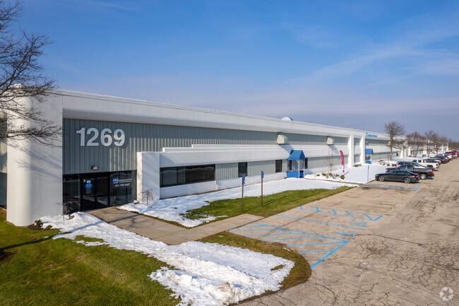
Property Record
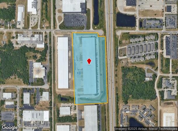
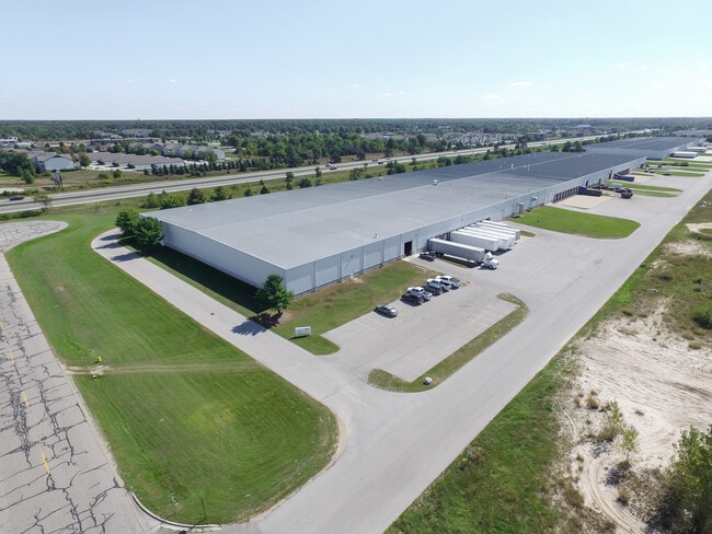
1269 E Mount Garfield Rd, Norton Shores, MI 49441
NEARBY LISTINGS FOR SALE OR LEASE
Property Detail
1269 E Mount Garfield Rd
27-128-200-0002-00
CITY OF NORTON SHORES PART OF E 1/2 OF SEC 28 COM AT S 1/4 COR OF SD SEC TH S 88D 28M 58S E 280.30 FT ALG S SEC LN TH N 00D
Industrialgeneral
Muskegon
X
Michigan
26121C0289E
18.72 AC
2024
Norton Shores
2025
West Michigan
002602
Muskegon, MI
250,000 SF
DEMOGRAPHICS near 1269 E Mount Garfield Rd
1 Mile
3 Mile
5 Mile
2024 Total Population
2,069
17,351
67,200
2029 Population
2,084
17,485
68,549
Pop Growth 2024-2029
+ 0.72%
+ 0.77%
+ 2.01%
Average Age
42
43
42
2024 Total Households
914
6,994
26,102
HH Growth 2024-2029
+ 0.77%
+ 0.77%
+ 2.15%
Median Household Inc
$59,160
$73,485
$60,275
Avg Household Size
2.20
2.40
2.40
2024 Avg HH Vehicles
2.00
2.00
2.00
Median Home Value
$249,342
$216,558
$192,843
Median Year Built
2002
1985
1973
Nearby Places
Map Layers
Map Styles
 Street
 Aerial
- Restaurants
- Banks
- Shops
- Fitness
- Groceries
SALE & LEASE HISTORY
LISTING DATE
SALE/LEASE

Sep 26, 2024
For Lease
Mar 17, 2017
For Lease
Mar 17, 2017
For Lease
Jun 20, 2022
For Lease
Feb 08, 2021
For Lease
Nearby Properties
Address
Land Use
TOTAL SIZE
Lot Size
Zoning
Address
Land Use
TOTAL SIZE
Lot Size
Zoning
381,476 SF
17.96 AC
I INDU
Address
Land Use
TOTAL SIZE
Lot Size
Zoning
350,077 SF
41.42 AC
PUD
Address
Land Use
TOTAL SIZE
Lot Size
Zoning
273,059 SF
30.59 AC
PUD
Address
Land Use
TOTAL SIZE
Lot Size
Zoning
192,833 SF
14.44 AC
I INDU
Address
Land Use
TOTAL SIZE
Lot Size
Zoning
65,152 SF
9.77 AC
PUD
Address
Land Use
TOTAL SIZE
Lot Size
Zoning
147,000 SF
GI
Address
Land Use
TOTAL SIZE
Lot Size
Zoning
237,612 SF
13.40 AC
PUD
Address
Land Use
TOTAL SIZE
Lot Size
Zoning
250,000 SF
19.08 AC
GI
Address
Land Use
TOTAL SIZE
Lot Size
Zoning
275,714 SF
17.26 AC
PUD
Address
Land Use
TOTAL SIZE
Lot Size
Zoning
250,000 SF
15.60 AC
GI
Address
Land Use
TOTAL SIZE
Lot Size
Zoning
169,420 SF
15.20 AC
PUD
Address
Land Use
TOTAL SIZE
Lot Size
Zoning
149,707 SF
35.72 AC
GI
Address
Land Use
TOTAL SIZE
Lot Size
Zoning
91,682 SF
21.93 AC
PUD
Address
Land Use
TOTAL SIZE
Lot Size
Zoning
184,786 SF
24.10 AC
SUD
Address
Land Use
TOTAL SIZE
Lot Size
Zoning
125,059 SF
10.47 AC
PUD
Address
Land Use
TOTAL SIZE
Lot Size
Zoning
117,950 SF
10 AC
GI
Address
Land Use
TOTAL SIZE
Lot Size
Zoning
204.11 AC
REC
Address
Land Use
TOTAL SIZE
Lot Size
Zoning
106,000 SF
GI
Address
Land Use
TOTAL SIZE
Lot Size
Zoning
141,007 SF
12.86 AC
GI
Address
Land Use
TOTAL SIZE
Lot Size
Zoning
118,532 SF
8.16 AC
REC
Address
Land Use
TOTAL SIZE
Lot Size
Zoning
113,167 SF
6.72 AC
I INDU
Address
Land Use
TOTAL SIZE
Lot Size
Zoning
63,512 SF
6.22 AC
PUD
Address
Land Use
TOTAL SIZE
Lot Size
Zoning
215,706 SF
23.21 AC
PUD
Address
Land Use
TOTAL SIZE
Lot Size
Zoning
50,252 SF
6.94 AC
C-2
Address
Land Use
TOTAL SIZE
Lot Size
Zoning
356,647 SF
53.83 AC
PUD
Address
Land Use
TOTAL SIZE
Lot Size
Zoning
63,266 SF
12.44 AC
I INDU
Address
Land Use
TOTAL SIZE
Lot Size
Zoning
65,204 SF
2.43 AC
PUD
Address
Land Use
TOTAL SIZE
Lot Size
Zoning
81,894 SF
8.60 AC
I INDU
Address
Land Use
TOTAL SIZE
Lot Size
Zoning
74,151 SF
6.03 AC
I INDU
Address
Land Use
TOTAL SIZE
Lot Size
Zoning
80,000 SF
GI
The World's #1 Commercial Real Estate Marketplace
Connect with us
© 2026 CoStar Group
The information above has been obtained from sources believed reliable. While we do not doubt its accuracy we have not verified it and make no guarantee, warranty or representation about it. It is your responsibility to independently confirm its accuracy and completeness. Any projections, opinions, assumptions, or estimates used are for example only and do not represent the current or future performance of the property. The value of this transaction to you depends on tax and other factors which should be evaluated by your tax, financial, and legal advisors. You and your advisors should conduct a careful, independent investigation of the property to determine to your satisfaction the suitability of the property for your needs.