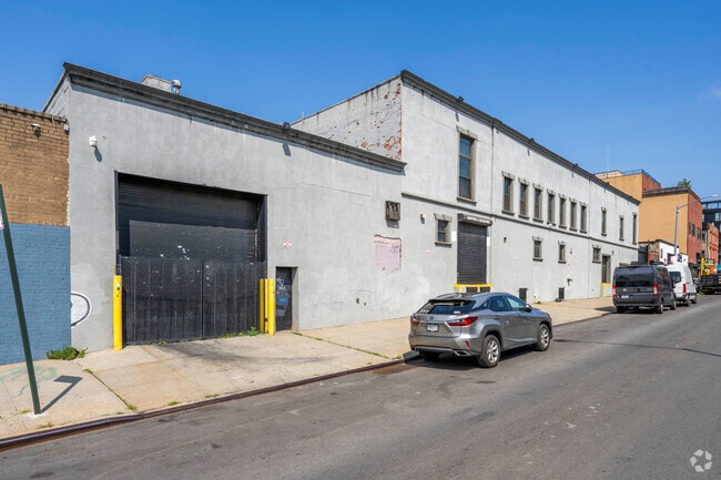
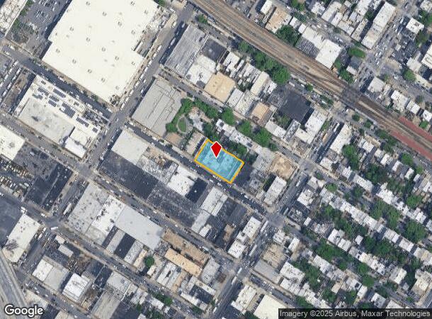
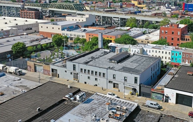
Property Record
121 12Th St, Brooklyn, NY 11215

Current Lease Availabilities
NEARBY LISTINGS FOR SALE OR LEASE
Property Detail
121 12Th St
01020-0052
Kings
Industrialgeneral
New York
X
52
3604970211F
0.41 AC
2024
North Brooklyn
2025
Long Island (New York)
011700
New York-Jersey City-White Plains, NY-NJ
25,334 SF
DEMOGRAPHICS near 121 12Th St
1 mile
3 mile
5 mile
2024 Total Population
100,336
998,807
2,556,295
2029 Population
94,242
941,296
2,402,331
Pop Growth 2024-2029
(6.07%)
(5.76%)
(6.02%)
Average Age
38
37
38
2024 Total Households
42,037
381,311
1,008,282
HH Growth 2024-2029
(6.66%)
(6.01%)
(6.28%)
Median Household Inc
$126,235
$83,762
$80,282
Avg Household Size
2.30
2.50
2.40
2024 Avg HH Vehicles
1.00
.00
.00
Median Home Value
$1,092,339
$1,012,899
$912,723
Median Year Built
1946
1948
1948
Nearby Places
Map Layers
Map Styles
 Street
 Aerial
Transit
 Traffic
 Biking
Places
Listings with unknown addresses are not visible on the map
- Restaurants
- Banks
- Shops
- Fitness
- Groceries
PUBLIC TRANSPORTATION
TRANSIT/SUBWAY
4 Avenue-9 Street (D,M,N,R Line) (D - New York MTA Subway (The Subway), M - New York MTA Subway (The Subway), N - New York MTA Subway (The Subway), R - New York MTA Subway (The Subway))
Drive
Walk
Distance
4 Avenue-9 Street (D,M,N,R Line) (D - New York MTA Subway (The Subway), M - New York MTA Subway (The Subway), N - New York MTA Subway (The Subway), R - New York MTA Subway (The Subway))
2 min
7 min
0.3 mi
4 Avenue-9 Street (F,G Line) (F - New York MTA Subway (The Subway))
Drive
Walk
Distance
4 Avenue-9 Street (F,G Line) (F - New York MTA Subway (The Subway))
1 min
7 min
0.4 mi
Smith-9 Streets (F - New York MTA Subway (The Subway), G - New York MTA Subway (The Subway))
Drive
Walk
Distance
Smith-9 Streets (F - New York MTA Subway (The Subway), G - New York MTA Subway (The Subway))
2 min
8 min
0.4 mi
Prospect Avenue (D,M,N,R Line) (D - New York MTA Subway (The Subway), M - New York MTA Subway (The Subway), N - New York MTA Subway (The Subway), R - New York MTA Subway (The Subway))
Drive
Walk
Distance
Prospect Avenue (D,M,N,R Line) (D - New York MTA Subway (The Subway), M - New York MTA Subway (The Subway), N - New York MTA Subway (The Subway), R - New York MTA Subway (The Subway))
2 min
9 min
0.5 mi
Union Street (D - New York MTA Subway (The Subway), M - New York MTA Subway (The Subway), N - New York MTA Subway (The Subway), R - New York MTA Subway (The Subway))
Drive
Walk
Distance
Union Street (D - New York MTA Subway (The Subway), M - New York MTA Subway (The Subway), N - New York MTA Subway (The Subway), R - New York MTA Subway (The Subway))
3 min
17 min
0.9 mi
COMMUTER RAIL
Drive
Walk
Distance
7 min
1.8 mi
Nostrand Avenue Station (Far Rockaway Branch - Long Island Rail Road, Hempstead Branch - Long Island Rail Road, Long Beach Branch - Long Island Rail Road, West Hempstead Branch - Long Island Rail Road)
Drive
Walk
Distance
Nostrand Avenue Station (Far Rockaway Branch - Long Island Rail Road, Hempstead Branch - Long Island Rail Road, Long Beach Branch - Long Island Rail Road, West Hempstead Branch - Long Island Rail Road)
10 min
3.3 mi
AIRPORT
LaGuardia
Drive
Walk
Distance
LaGuardia
24 min
12.7 mi
John F Kennedy International
Drive
Walk
Distance
John F Kennedy International
27 min
14.6 mi
Newark Liberty International
Drive
Walk
Distance
Newark Liberty International
28 min
16.2 mi
Freight Ports
NY - Red Hook Container Terminal
Drive
Walk
Distance
NY - Red Hook Container Terminal
4 min
1.6 mi
Nearby Properties
Address
Land Use
TOTAL SIZE
Lot Size
Zoning
Address
Land Use
TOTAL SIZE
Lot Size
Zoning
8.22 AC
R8
Address
Land Use
TOTAL SIZE
Lot Size
Zoning
8.22 AC
R8
Address
Land Use
TOTAL SIZE
Lot Size
Zoning
7,058,736 SF
147.61 AC
M3-1
Address
Land Use
TOTAL SIZE
Lot Size
Zoning
869,038 SF
1.53 AC
M1-1
Address
Land Use
TOTAL SIZE
Lot Size
Zoning
92,440 SF
466.23 AC
R5
Address
Land Use
TOTAL SIZE
Lot Size
Zoning
2,210,200 SF
2.58 AC
C5-5
Address
Land Use
TOTAL SIZE
Lot Size
Zoning
1,362,190 SF
C5-5
Address
Land Use
TOTAL SIZE
Lot Size
Zoning
1,499,568 SF
1.66 AC
C5-5
Address
Land Use
TOTAL SIZE
Lot Size
Zoning
1,617,206 SF
1.23 AC
C5-5
Address
Land Use
TOTAL SIZE
Lot Size
Zoning
2,542,066 SF
174.49 AC
R3-2
Address
Land Use
TOTAL SIZE
Lot Size
Zoning
1,941,777 SF
8.22 AC
R8
Address
Land Use
TOTAL SIZE
Lot Size
Zoning
773,169 SF
C6-4
Address
Land Use
TOTAL SIZE
Lot Size
Zoning
1,503,150 SF
20.47 AC
R5
Address
Land Use
TOTAL SIZE
Lot Size
Zoning
1,075,808 SF
1.12 AC
C5-5
Address
Land Use
TOTAL SIZE
Lot Size
Zoning
1,141,276 SF
1.21 AC
C5-5
Address
Land Use
TOTAL SIZE
Lot Size
Zoning
393.54 AC
PARK
Address
Land Use
TOTAL SIZE
Lot Size
Zoning
945,425 SF
21.70 AC
PARK
Address
Land Use
TOTAL SIZE
Lot Size
Zoning
1,289,243 SF
1.14 AC
C5-5
Address
Land Use
TOTAL SIZE
Lot Size
Zoning
577,381 SF
3.19 AC
R6
Address
Land Use
TOTAL SIZE
Lot Size
Zoning
515,425 SF
4.29 AC
R7-2
Address
Land Use
TOTAL SIZE
Lot Size
Zoning
515,425 SF
4.29 AC
R7-2
Address
Land Use
TOTAL SIZE
Lot Size
Zoning
515,425 SF
4.29 AC
R7-2
Address
Land Use
TOTAL SIZE
Lot Size
Zoning
515,425 SF
4.29 AC
R7-2
Address
Land Use
TOTAL SIZE
Lot Size
Zoning
515,425 SF
4.29 AC
R7-2
Address
Land Use
TOTAL SIZE
Lot Size
Zoning
515,425 SF
4.29 AC
R7-2
Address
Land Use
TOTAL SIZE
Lot Size
Zoning
515,425 SF
4.29 AC
R7-2
Address
Land Use
TOTAL SIZE
Lot Size
Zoning
515,425 SF
4.29 AC
R7-2
Address
Land Use
TOTAL SIZE
Lot Size
Zoning
515,425 SF
4.29 AC
R7-2
Address
Land Use
TOTAL SIZE
Lot Size
Zoning
515,425 SF
4.29 AC
R7-2
Address
Land Use
TOTAL SIZE
Lot Size
Zoning
515,425 SF
4.29 AC
R7-2
The World's #1 Commercial Real Estate Marketplace
Connect with us
© 2026 CoStar Group
The information above has been obtained from sources believed reliable. While we do not doubt its accuracy we have not verified it and make no guarantee, warranty or representation about it. It is your responsibility to independently confirm its accuracy and completeness. Any projections, opinions, assumptions, or estimates used are for example only and do not represent the current or future performance of the property. The value of this transaction to you depends on tax and other factors which should be evaluated by your tax, financial, and legal advisors. You and your advisors should conduct a careful, independent investigation of the property to determine to your satisfaction the suitability of the property for your needs.