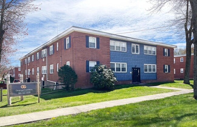
Property Record
127 Dogburn Rd, West Haven, CT 06516
NEARBY LISTINGS FOR SALE OR LEASE
Property Detail
127 Dogburn Rd
Apartmenthouse5plusunits
New Haven
X
Connecticut
09009C0436H
0.49 AC
2025
West Haven
2025
Westchester/So Connecticut
154102
New Haven, CT
14,136 SF
WHAV-000045-000011
DEMOGRAPHICS near 127 Dogburn Rd
1 Mile
3 Mile
5 Mile
2024 Total Population
10,237
81,255
206,445
2029 Population
10,146
80,147
204,720
Pop Growth 2024-2029
(0.89%)
(1.36%)
(0.84%)
Average Age
39
39
38
2024 Total Households
3,930
30,427
79,614
HH Growth 2024-2029
(0.97%)
(1.45%)
(0.85%)
Median Household Inc
$61,758
$68,956
$67,397
Avg Household Size
2.50
2.50
2.30
2024 Avg HH Vehicles
2.00
2.00
1.00
Median Home Value
$239,835
$254,350
$283,123
Median Year Built
1970
1957
1957
Nearby Places
Map Layers
Map Styles
 Street
 Aerial
- Restaurants
- Banks
- Shops
- Fitness
- Groceries
PUBLIC TRANSPORTATION
COMMUTER RAIL
West Haven (New Haven - Metro-North Railroad)
DRIVE
WALK
Distance
West Haven (New Haven - Metro-North Railroad)
4 min
1.9 mi
New Haven (New Haven - Metro-North Railroad)
DRIVE
WALK
Distance
New Haven (New Haven - Metro-North Railroad)
7 min
3.9 mi
AIRPORT
Tweed/New Haven
DRIVE
WALK
Distance
Tweed/New Haven
17 min
8.7 mi
Freight Ports
Port of New Haven
DRIVE
WALK
Distance
Port of New Haven
12 min
5.9 mi
Nearby Properties
Address
Land Use
TOTAL SIZE
Lot Size
Zoning
Address
Land Use
TOTAL SIZE
Lot Size
Zoning
56,359 SF
17.09 AC
RCPD
Address
Land Use
TOTAL SIZE
Lot Size
Zoning
50.14 AC
PRD
Address
Land Use
TOTAL SIZE
Lot Size
Zoning
81,870 SF
3.86 AC
RM2
Address
Land Use
TOTAL SIZE
Lot Size
Zoning
302,262 SF
10.40 AC
RM1
Address
Land Use
TOTAL SIZE
Lot Size
Zoning
42.52 AC
PF
Address
Land Use
TOTAL SIZE
Lot Size
Zoning
287,844 SF
2.11 AC
IL
Address
Land Use
TOTAL SIZE
Lot Size
Zoning
158,622 SF
2.09 AC
BA/RM2
Address
Land Use
TOTAL SIZE
Lot Size
Zoning
29.78 AC
PRD
Address
Land Use
TOTAL SIZE
Lot Size
Zoning
76,945 SF
8.52 AC
RM2
Address
Land Use
TOTAL SIZE
Lot Size
Zoning
35.05 AC
LI-2
Address
Land Use
TOTAL SIZE
Lot Size
Zoning
576 SF
RS2
Address
Land Use
TOTAL SIZE
Lot Size
Zoning
125,676 SF
22.12 AC
BOP
Address
Land Use
TOTAL SIZE
Lot Size
Zoning
46,962 SF
1.48 AC
RM1/RS
Address
Land Use
TOTAL SIZE
Lot Size
Zoning
63,304 SF
4.62 AC
RCPD
Address
Land Use
TOTAL SIZE
Lot Size
Zoning
161,426 SF
4.79 AC
EFD
Address
Land Use
TOTAL SIZE
Lot Size
Zoning
93,849 SF
3.16 AC
RM1
Address
Land Use
TOTAL SIZE
Lot Size
Zoning
13,204 SF
PDD 86
Address
Land Use
TOTAL SIZE
Lot Size
Zoning
84,689 SF
0.39 AC
BA/RM2
Address
Land Use
TOTAL SIZE
Lot Size
Zoning
154,315 SF
4.29 AC
SCR
Address
Land Use
TOTAL SIZE
Lot Size
Zoning
9 AC
LI-4
Address
Land Use
TOTAL SIZE
Lot Size
Zoning
162,464 SF
7.51 AC
SLD
Address
Land Use
TOTAL SIZE
Lot Size
Zoning
98,422 SF
1.78 AC
PDU 93
Address
Land Use
TOTAL SIZE
Lot Size
Zoning
140,962 SF
72.93 AC
IPD
Address
Land Use
TOTAL SIZE
Lot Size
Zoning
53,974 SF
4.02 AC
RM1/RS
Address
Land Use
TOTAL SIZE
Lot Size
Zoning
8,060 SF
27.12 AC
RPD
Address
Land Use
TOTAL SIZE
Lot Size
Zoning
20.33 AC
LI-3
Address
Land Use
TOTAL SIZE
Lot Size
Zoning
75,670 SF
34.18 AC
R2
Address
Land Use
TOTAL SIZE
Lot Size
Zoning
68,918 SF
0.85 AC
PDD 54
Address
Land Use
TOTAL SIZE
Lot Size
Zoning
90,749 SF
1.41 AC
RM2
Address
Land Use
TOTAL SIZE
Lot Size
Zoning
6.01 AC
LI-2
The World's #1 Commercial Real Estate Marketplace
Connect with us
© 2026 CoStar Group
The information above has been obtained from sources believed reliable. While we do not doubt its accuracy we have not verified it and make no guarantee, warranty or representation about it. It is your responsibility to independently confirm its accuracy and completeness. Any projections, opinions, assumptions, or estimates used are for example only and do not represent the current or future performance of the property. The value of this transaction to you depends on tax and other factors which should be evaluated by your tax, financial, and legal advisors. You and your advisors should conduct a careful, independent investigation of the property to determine to your satisfaction the suitability of the property for your needs.