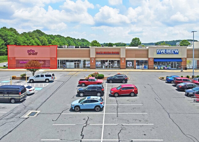
Property Record
127 E North Pointe Dr, Salisbury, MD 21804

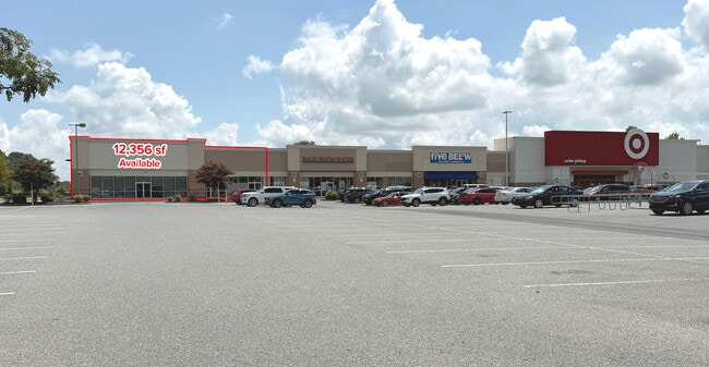

Current Lease Availabilities
Property Detail
127 E North Pointe Dr
05-111242
LOT 3-2.52 AC 127 E NORTH POINTE DRIVE ROLAND DASHIELL SUB
Stripcommercialcenter
Wicomico
GC
Maryland
B and X Area of moderate flood hazard, usually the area between the limits of the 100-year and 500-year floods.
3
2025
2.52 AC
2025
Chesapeake Bay/Salisbury
010603
Other Market Areas
27,440 SF
Salisbury, MD
NEARBY LISTINGS FOR SALE OR LEASE
DEMOGRAPHICS near 127 E North Pointe Dr
1 mile
3 mile
5 mile
2025 Total Population
3,293
20,297
56,541
2030 Population
3,409
20,841
58,100
Pop Growth 2025-2030
+ 3.52%
+ 2.68%
+ 2.76%
Average Age
38
39
39
2025 Total Households
1,501
8,026
22,424
HH Growth 2025-2030
+ 3.66%
+ 2.77%
+ 2.76%
Median Household Inc
$68,596
$71,569
$62,552
Avg Household Size
2.20
2.40
2.40
2025 Avg HH Vehicles
2.00
2.00
2.00
Median Home Value
$234,493
$241,473
$228,919
Median Year Built
2001
1982
1977
Nearby Places
Map Layers
Map Styles
 Street
 Aerial
Layers
 Traffic
 Biking
Places
Listings with unknown addresses are not visible on the map
- Restaurants
- Banks
- Shops
- Fitness
- Groceries
PUBLIC TRANSPORTATION
AIRPORT
Salisbury-Ocean City Wicomico Regional
Drive
Walk
Distance
Salisbury-Ocean City Wicomico Regional
20 min
9.9 mi
Freight Ports
Port of Baltimore
Drive
Walk
Distance
Port of Baltimore
151 min
102.5 mi
Nearby Properties
Address
Land Use
TOTAL SIZE
Lot Size
Zoning
Address
Land Use
TOTAL SIZE
Lot Size
Zoning
28,442 SF
34.88 AC
GC
Address
Land Use
TOTAL SIZE
Lot Size
Zoning
25,000 SF
23.46 AC
I-2
Address
Land Use
TOTAL SIZE
Lot Size
Zoning
79,596 SF
21.52 AC
Address
Land Use
TOTAL SIZE
Lot Size
Zoning
9,222 SF
36.49 AC
R2
Address
Land Use
TOTAL SIZE
Lot Size
Zoning
27,570 SF
25.81 AC
R2
Address
Land Use
TOTAL SIZE
Lot Size
Zoning
219,584 SF
23.60 AC
PRD
Address
Land Use
TOTAL SIZE
Lot Size
Zoning
488,450 SF
28.70 AC
GC
Address
Land Use
TOTAL SIZE
Lot Size
Zoning
28,365 SF
11.21 AC
R1A
Address
Land Use
TOTAL SIZE
Lot Size
Zoning
15,531 SF
15.26 AC
GC
Address
Land Use
TOTAL SIZE
Lot Size
Zoning
92,168 SF
13.40 AC
Address
Land Use
TOTAL SIZE
Lot Size
Zoning
88,872 SF
8.48 AC
PRD
Address
Land Use
TOTAL SIZE
Lot Size
Zoning
213,442 SF
17.91 AC
GC
Address
Land Use
TOTAL SIZE
Lot Size
Zoning
5,151 SF
13.23 AC
LI
Address
Land Use
TOTAL SIZE
Lot Size
Zoning
92,232 SF
20.83 AC
C
Address
Land Use
TOTAL SIZE
Lot Size
Zoning
56,301 SF
26.25 AC
Address
Land Use
TOTAL SIZE
Lot Size
Zoning
9,600 SF
19.27 AC
ARR
Address
Land Use
TOTAL SIZE
Lot Size
Zoning
37,645 SF
16.43 AC
IP
Address
Land Use
TOTAL SIZE
Lot Size
Zoning
4,181 SF
4.45 AC
GC
Address
Land Use
TOTAL SIZE
Lot Size
Zoning
22,583 SF
7.54 AC
Address
Land Use
TOTAL SIZE
Lot Size
Zoning
44,260 SF
4.62 AC
C
Address
Land Use
TOTAL SIZE
Lot Size
Zoning
134,313 SF
12.90 AC
GC
Address
Land Use
TOTAL SIZE
Lot Size
Zoning
73,424 SF
2.90 AC
R1A
Address
Land Use
TOTAL SIZE
Lot Size
Zoning
20,970 SF
3.52 AC
Address
Land Use
TOTAL SIZE
Lot Size
Zoning
27,432 SF
6.40 AC
Address
Land Use
TOTAL SIZE
Lot Size
Zoning
171,072 SF
15.19 AC
R-8A
Address
Land Use
TOTAL SIZE
Lot Size
Zoning
104,000 SF
9.47 AC
GC
Address
Land Use
TOTAL SIZE
Lot Size
Zoning
29,445 SF
5.09 AC
C 2
Address
Land Use
TOTAL SIZE
Lot Size
Zoning
22,373 SF
4 AC
C
Address
Land Use
TOTAL SIZE
Lot Size
Zoning
5,040 SF
2.01 AC
GC
Address
Land Use
TOTAL SIZE
Lot Size
Zoning
25,642 SF
7.70 AC
CI
The World's #1 Commercial Real Estate Marketplace
Connect with us
© 2026 CoStar Group
The information above has been obtained from sources believed reliable. While we do not doubt its accuracy we have not verified it and make no guarantee, warranty or representation about it. It is your responsibility to independently confirm its accuracy and completeness. Any projections, opinions, assumptions, or estimates used are for example only and do not represent the current or future performance of the property. The value of this transaction to you depends on tax and other factors which should be evaluated by your tax, financial, and legal advisors. You and your advisors should conduct a careful, independent investigation of the property to determine to your satisfaction the suitability of the property for your needs.