Property Record
127 E Spring St, Bechtelsville, PA 19505
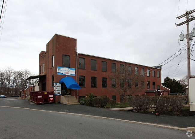

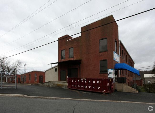

Property Detail
127 E Spring St
26-5398-09-15-7930
Berks
Warehouse
Pennsylvania
B and X Area of moderate flood hazard, usually the area between the limits of the 100-year and 500-year floods.
8.94 AC
2025
Berks
2025
Philadelphia
013302
Reading, PA
69,769 SF
NEARBY LISTINGS FOR SALE OR LEASE
DEMOGRAPHICS near 127 E Spring St
1 mile
3 mile
5 mile
2025 Total Population
2,572
14,749
34,732
2030 Population
2,667
15,036
35,451
Pop Growth 2025-2030
+ 3.69%
+ 1.95%
+ 2.07%
Average Age
45
44
43
2025 Total Households
1,025
5,984
13,553
HH Growth 2025-2030
+ 3.71%
+ 1.96%
+ 2.05%
Median Household Inc
$96,149
$86,248
$93,699
Avg Household Size
2.50
2.40
2.50
2025 Avg HH Vehicles
2.00
2.00
2.00
Median Home Value
$308,527
$298,316
$336,129
Median Year Built
1969
1966
1973
Nearby Places
Map Layers
Map Styles
 Street
 Aerial
Transit
 Traffic
 Biking
Places
Listings with unknown addresses are not visible on the map
- Restaurants
- Banks
- Shops
- Fitness
- Groceries
PUBLIC TRANSPORTATION
AIRPORT
Lehigh Valley International
Drive
Walk
Distance
Lehigh Valley International
47 min
25.7 mi
Freight Ports
Port of Philadelphia
Drive
Walk
Distance
Port of Philadelphia
75 min
44.6 mi
Nearby Properties
Address
Land Use
TOTAL SIZE
Lot Size
Zoning
Address
Land Use
TOTAL SIZE
Lot Size
Zoning
188,596 SF
24.21 AC
Address
Land Use
TOTAL SIZE
Lot Size
Zoning
89,618 SF
11.02 AC
M1
Address
Land Use
TOTAL SIZE
Lot Size
Zoning
71,093 SF
2.64 AC
Address
Land Use
TOTAL SIZE
Lot Size
Zoning
47,136 SF
2.49 AC
Address
Land Use
TOTAL SIZE
Lot Size
Zoning
224,550 SF
21.20 AC
Address
Land Use
TOTAL SIZE
Lot Size
Zoning
113,341 SF
11.03 AC
Address
Land Use
TOTAL SIZE
Lot Size
Zoning
48,320 SF
5 AC
GC
Address
Land Use
TOTAL SIZE
Lot Size
Zoning
65,162 SF
9.05 AC
GC
Address
Land Use
TOTAL SIZE
Lot Size
Zoning
44,060 SF
24.54 AC
Address
Land Use
TOTAL SIZE
Lot Size
Zoning
236,153 SF
30.47 AC
M2
Address
Land Use
TOTAL SIZE
Lot Size
Zoning
161,138 SF
160.99 AC
Address
Land Use
TOTAL SIZE
Lot Size
Zoning
27,733 SF
2 AC
IN
Address
Land Use
TOTAL SIZE
Lot Size
Zoning
20,388 SF
2.70 AC
Address
Land Use
TOTAL SIZE
Lot Size
Zoning
32,160 SF
7.05 AC
Address
Land Use
TOTAL SIZE
Lot Size
Zoning
26,906 SF
4.41 AC
M1
Address
Land Use
TOTAL SIZE
Lot Size
Zoning
257,437 SF
15.06 AC
Address
Land Use
TOTAL SIZE
Lot Size
Zoning
155,575 SF
9.12 AC
Address
Land Use
TOTAL SIZE
Lot Size
Zoning
109,828 SF
18.09 AC
Address
Land Use
TOTAL SIZE
Lot Size
Zoning
290,806 SF
13.05 AC
Address
Land Use
TOTAL SIZE
Lot Size
Zoning
1,769 SF
23.39 AC
Address
Land Use
TOTAL SIZE
Lot Size
Zoning
23,350 SF
3.74 AC
Address
Land Use
TOTAL SIZE
Lot Size
Zoning
34,000 SF
13.69 AC
Address
Land Use
TOTAL SIZE
Lot Size
Zoning
12,129 SF
2.10 AC
Address
Land Use
TOTAL SIZE
Lot Size
Zoning
41,872 SF
4.28 AC
M1
Address
Land Use
TOTAL SIZE
Lot Size
Zoning
24,932 SF
1.56 AC
Address
Land Use
TOTAL SIZE
Lot Size
Zoning
34,440 SF
5 AC
M1
Address
Land Use
TOTAL SIZE
Lot Size
Zoning
17,950 SF
9.22 AC
M2
Address
Land Use
TOTAL SIZE
Lot Size
Zoning
119.80 AC
Address
Land Use
TOTAL SIZE
Lot Size
Zoning
107,744 SF
7.95 AC
The World's #1 Commercial Real Estate Marketplace
Connect with us
© 2026 CoStar Group
The information above has been obtained from sources believed reliable. While we do not doubt its accuracy we have not verified it and make no guarantee, warranty or representation about it. It is your responsibility to independently confirm its accuracy and completeness. Any projections, opinions, assumptions, or estimates used are for example only and do not represent the current or future performance of the property. The value of this transaction to you depends on tax and other factors which should be evaluated by your tax, financial, and legal advisors. You and your advisors should conduct a careful, independent investigation of the property to determine to your satisfaction the suitability of the property for your needs.