Property Record
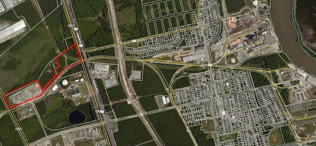
127 Gulfstream Rd, Savannah, GA 31408

Property Detail
127 Gulfstream Rd
2097201002
PARCELS A & B LANDS OF SOUTHERN REGION INDUSTRIAL REALTY INC &
Industrialacreage
CHATHAM
PIL
Georgia
B and X Area of moderate flood hazard, usually the area between the limits of the 100-year and 500-year floods.
37.25 AC
2025
N Savannah/Garden City
2025
Savannah
010701
Savannah, GA
NEARBY LISTINGS FOR SALE OR LEASE
DEMOGRAPHICS near 127 Gulfstream Rd
1 mile
3 mile
5 mile
2025 Total Population
552
7,575
45,069
2030 Population
570
7,909
47,291
Pop Growth 2025-2030
+ 3.26%
+ 4.41%
+ 4.93%
Average Age
43
39
37
2025 Total Households
62
2,520
17,169
HH Growth 2025-2030
+ 4.84%
+ 4.92%
+ 5.15%
Median Household Inc
$65,416
$69,160
$80,006
Avg Household Size
2.50
2.50
2.50
2025 Avg HH Vehicles
2.00
2.00
2.00
Median Home Value
$227,272
$230,219
$269,745
Median Year Built
1996
1991
2004
Nearby Places
Map Layers
Map Styles
 Street
 Aerial
Layers
 Traffic
 Biking
Places
Listings with unknown addresses are not visible on the map
- Restaurants
- Banks
- Shops
- Fitness
- Groceries
PUBLIC TRANSPORTATION
COMMUTER RAIL
Drive
Walk
Distance
16 min
7.7 mi
AIRPORT
Savannah/Hilton Head International
Drive
Walk
Distance
Savannah/Hilton Head International
13 min
4.8 mi
Hilton Head
Drive
Walk
Distance
Hilton Head
56 min
40.9 mi
SALE & LEASE HISTORY
LISTING DATE
SALE/LEASE

May 24, 2019
For Sale
Jul 03, 2019
For Sale
Nearby Properties
Address
Land Use
TOTAL SIZE
Lot Size
Zoning
Address
Land Use
TOTAL SIZE
Lot Size
Zoning
1,008 SF
150 AC
I-H
Address
Land Use
TOTAL SIZE
Lot Size
Zoning
1,400,224 SF
325.62 AC
I-H
Address
Land Use
TOTAL SIZE
Lot Size
Zoning
426,547 SF
15.29 AC
Address
Land Use
TOTAL SIZE
Lot Size
Zoning
432,965 SF
10.09 AC
Address
Land Use
TOTAL SIZE
Lot Size
Zoning
1,275,180 SF
0.02 AC
Address
Land Use
TOTAL SIZE
Lot Size
Zoning
1,164,800 SF
86.22 AC
Address
Land Use
TOTAL SIZE
Lot Size
Zoning
1,115,200 SF
81.30 AC
Address
Land Use
TOTAL SIZE
Lot Size
Zoning
605,200 SF
59.62 AC
I-H
Address
Land Use
TOTAL SIZE
Lot Size
Zoning
1,003,267 SF
64.07 AC
I-H
Address
Land Use
TOTAL SIZE
Lot Size
Zoning
588,726 SF
0.30 AC
I-L
Address
Land Use
TOTAL SIZE
Lot Size
Zoning
800,100 SF
44.51 AC
I-H
Address
Land Use
TOTAL SIZE
Lot Size
Zoning
754,000 SF
63.38 AC
I-H
Address
Land Use
TOTAL SIZE
Lot Size
Zoning
750,480 SF
52.93 AC
IH
Address
Land Use
TOTAL SIZE
Lot Size
Zoning
737,500 SF
49.38 AC
I-1
Address
Land Use
TOTAL SIZE
Lot Size
Zoning
70,000 SF
71.90 AC
IH
Address
Land Use
TOTAL SIZE
Lot Size
Zoning
752,000 SF
51.18 AC
Address
Land Use
TOTAL SIZE
Lot Size
Zoning
70.39 AC
Address
Land Use
TOTAL SIZE
Lot Size
Zoning
24,648 SF
23.38 AC
Address
Land Use
TOTAL SIZE
Lot Size
Zoning
631,800 SF
38.47 AC
Address
Land Use
TOTAL SIZE
Lot Size
Zoning
9,505 SF
0.07 AC
Address
Land Use
TOTAL SIZE
Lot Size
Zoning
285,905 SF
20.16 AC
I-L
Address
Land Use
TOTAL SIZE
Lot Size
Zoning
20,210 SF
85.60 AC
I-H
Address
Land Use
TOTAL SIZE
Lot Size
Zoning
2,156 SF
36.64 AC
PIL
Address
Land Use
TOTAL SIZE
Lot Size
Zoning
10,600 SF
21.93 AC
PUD
Address
Land Use
TOTAL SIZE
Lot Size
Zoning
515,800 SF
36.16 AC
Address
Land Use
TOTAL SIZE
Lot Size
Zoning
3,648 SF
66.30 AC
I-L
Address
Land Use
TOTAL SIZE
Lot Size
Zoning
499,200 SF
33.02 AC
PUDC
Address
Land Use
TOTAL SIZE
Lot Size
Zoning
408 SF
47.25 AC
I-H
Address
Land Use
TOTAL SIZE
Lot Size
Zoning
600,000 SF
62.25 AC
I-H
Address
Land Use
TOTAL SIZE
Lot Size
Zoning
252,000 SF
31.18 AC
I-H
The World's #1 Commercial Real Estate Marketplace
Connect with us
© 2026 CoStar Group
The information above has been obtained from sources believed reliable. While we do not doubt its accuracy we have not verified it and make no guarantee, warranty or representation about it. It is your responsibility to independently confirm its accuracy and completeness. Any projections, opinions, assumptions, or estimates used are for example only and do not represent the current or future performance of the property. The value of this transaction to you depends on tax and other factors which should be evaluated by your tax, financial, and legal advisors. You and your advisors should conduct a careful, independent investigation of the property to determine to your satisfaction the suitability of the property for your needs.