Property Record
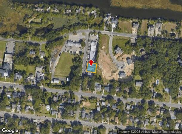
127 Laurel Ave, Island Heights, NJ 08732
NEARBY LISTINGS FOR SALE OR LEASE
-
-
View all Island Heights listings for lease on LoopNet.com
Property Detail
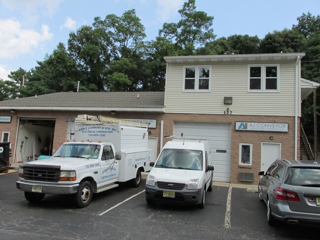
127 Laurel Ave
New York-Jersey City-White Plains, NY-NJ
Steve Nelson
11-00038-01-00024-07
85X100
Commercialnec
Ocean
X
New Jersey
34029C0309F
24.7
2024
0.20 AC
2025
Ocean County
726000
Northern New Jersey
4,959 SF
DEMOGRAPHICS near 127 Laurel Ave
1 Mile
3 Mile
5 Mile
2024 Total Population
8,998
60,074
130,519
2029 Population
9,599
63,969
140,967
Pop Growth 2024-2029
+ 6.68%
+ 6.48%
+ 8.00%
Average Age
40
40
41
2024 Total Households
3,435
21,894
49,716
HH Growth 2024-2029
+ 6.38%
+ 6.08%
+ 8.15%
Median Household Inc
$74,961
$89,507
$87,710
Avg Household Size
2.50
2.60
2.50
2024 Avg HH Vehicles
2.00
2.00
2.00
Median Home Value
$317,863
$324,661
$353,407
Median Year Built
1966
1973
1975
Nearby Places
Map Layers
Map Styles
 Street
 Aerial
- Restaurants
- Banks
- Shops
- Fitness
- Groceries
SALE & LEASE HISTORY
LISTING DATE
SALE/LEASE

Sep 25, 2016
For Lease
Sep 24, 2016
For Sale
Jan 24, 2018
For Lease
Nearby Properties
Address
Land Use
TOTAL SIZE
Lot Size
Zoning
Address
Land Use
TOTAL SIZE
Lot Size
Zoning
44,584 SF
11.85 AC
VO
Address
Land Use
TOTAL SIZE
Lot Size
Zoning
8,512 SF
25.67 AC
RC
Address
Land Use
TOTAL SIZE
Lot Size
Zoning
8,118 SF
72.32 AC
R75
Address
Land Use
TOTAL SIZE
Lot Size
Zoning
8.21 AC
VO
Address
Land Use
TOTAL SIZE
Lot Size
Zoning
8,968 SF
26.36 AC
RMF
Address
Land Use
TOTAL SIZE
Lot Size
Zoning
31,302 SF
13.76 AC
EM18
Address
Land Use
TOTAL SIZE
Lot Size
Zoning
18,890 SF
24.59 AC
SPLT
Address
Land Use
TOTAL SIZE
Lot Size
Zoning
56,332 SF
8.85 AC
SPLT
Address
Land Use
TOTAL SIZE
Lot Size
Zoning
15.68 AC
MF8
Address
Land Use
TOTAL SIZE
Lot Size
Zoning
2,549 SF
16.02 AC
RC
Address
Land Use
TOTAL SIZE
Lot Size
Zoning
71,285 SF
20.49 AC
HB
Address
Land Use
TOTAL SIZE
Lot Size
Zoning
1,680 SF
14.33 AC
HB
Address
Land Use
TOTAL SIZE
Lot Size
Zoning
8.82 AC
O15
Address
Land Use
TOTAL SIZE
Lot Size
Zoning
103,750 SF
24.23 AC
R120
Address
Land Use
TOTAL SIZE
Lot Size
Zoning
33.59 AC
R90
Address
Land Use
TOTAL SIZE
Lot Size
Zoning
5,303 SF
2.14 AC
VO
Address
Land Use
TOTAL SIZE
Lot Size
Zoning
23.28 AC
R75
Address
Land Use
TOTAL SIZE
Lot Size
Zoning
22.29 AC
HB
Address
Land Use
TOTAL SIZE
Lot Size
Zoning
3,524 SF
10 AC
HB
Address
Land Use
TOTAL SIZE
Lot Size
Zoning
22,908 SF
6.81 AC
EM10
Address
Land Use
TOTAL SIZE
Lot Size
Zoning
648 SF
9.52 AC
HB
Address
Land Use
TOTAL SIZE
Lot Size
Zoning
54,648 SF
8.04 AC
HB
Address
Land Use
TOTAL SIZE
Lot Size
Zoning
88,355 SF
5.27 AC
HB
Address
Land Use
TOTAL SIZE
Lot Size
Zoning
2,792 SF
13.72 AC
R100
Address
Land Use
TOTAL SIZE
Lot Size
Zoning
59,100 SF
11.56 AC
HB
Address
Land Use
TOTAL SIZE
Lot Size
Zoning
61,176 SF
9.31 AC
HB
Address
Land Use
TOTAL SIZE
Lot Size
Zoning
10.02 AC
O15
Address
Land Use
TOTAL SIZE
Lot Size
Zoning
1,740 SF
38.81 AC
HB
Address
Land Use
TOTAL SIZE
Lot Size
Zoning
69,798 SF
6.92 AC
R200
Address
Land Use
TOTAL SIZE
Lot Size
Zoning
4.80 AC
HB
The World's #1 Commercial Real Estate Marketplace
Connect with us
© 2025 CoStar Group
The information above has been obtained from sources believed reliable. While we do not doubt its accuracy we have not verified it and make no guarantee, warranty or representation about it. It is your responsibility to independently confirm its accuracy and completeness. Any projections, opinions, assumptions, or estimates used are for example only and do not represent the current or future performance of the property. The value of this transaction to you depends on tax and other factors which should be evaluated by your tax, financial, and legal advisors. You and your advisors should conduct a careful, independent investigation of the property to determine to your satisfaction the suitability of the property for your needs.