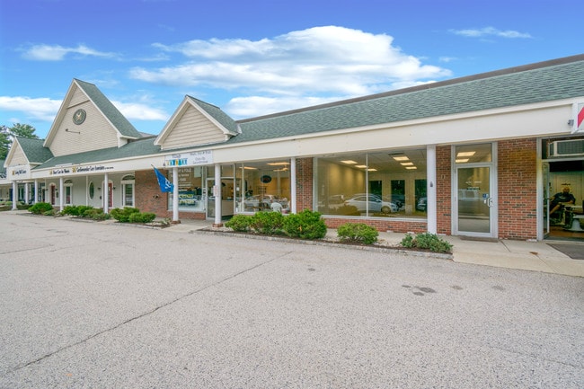
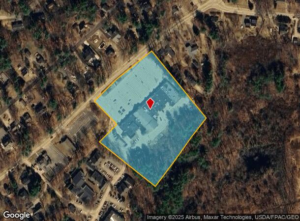
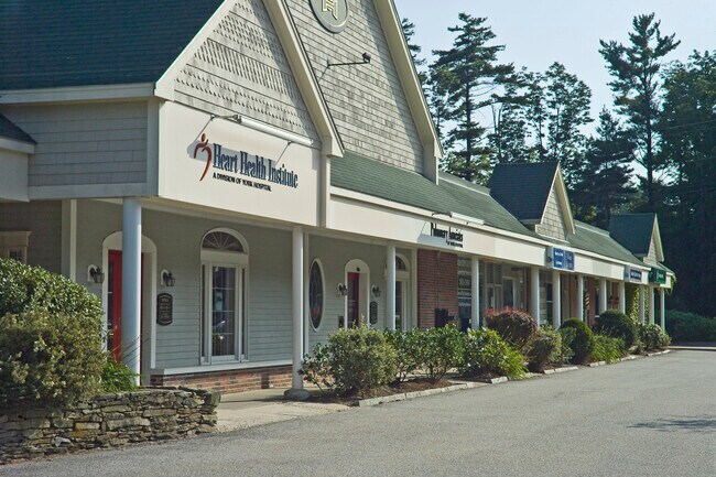
Property Record
127 Long Sands Rd, York, ME 03909
NEARBY LISTINGS FOR SALE OR LEASE
-
-
View all York listings for lease on LoopNet.com
Property Detail
127 Long Sands Rd
Regionalshoppingcenterormallwithanchorstore
York
X
Maine
23031C0669G
6.42 AC
2024
York County
2024
Portland/South Portland
036003
Portland-South Portland, ME
50,064 SF
YORK-000044-000000-000046
DEMOGRAPHICS near 127 Long Sands Rd
1 Mile
3 Mile
5 Mile
2024 Total Population
2,804
9,526
15,814
2029 Population
2,963
10,047
16,691
Pop Growth 2024-2029
+ 5.67%
+ 5.47%
+ 5.55%
Average Age
51
50
48
2024 Total Households
1,261
4,161
6,823
HH Growth 2024-2029
+ 5.63%
+ 5.41%
+ 5.50%
Median Household Inc
$66,720
$99,534
$101,977
Avg Household Size
2.10
2.20
2.30
2024 Avg HH Vehicles
2.00
2.00
2.00
Median Home Value
$543,142
$532,574
$481,015
Median Year Built
1979
1975
1976
Nearby Places
Map Layers
Map Styles
 Street
 Aerial
- Restaurants
- Banks
- Shops
- Fitness
- Groceries
PUBLIC TRANSPORTATION
AIRPORT
Portsmouth International at Pease
DRIVE
WALK
Distance
Portsmouth International at Pease
22 min
12.6 mi
Freight Ports
Portland, ME
DRIVE
WALK
Distance
Portland, ME
55 min
44.9 mi
SALE & LEASE HISTORY
LISTING DATE
SALE/LEASE

Oct 03, 2023
For Lease
Dec 26, 2017
For Lease
Aug 30, 2019
For Lease
Nearby Properties
Address
Land Use
TOTAL SIZE
Lot Size
Zoning
Address
Land Use
TOTAL SIZE
Lot Size
Zoning
1 AC
B-1
Address
Land Use
TOTAL SIZE
Lot Size
Zoning
12.10 AC
R1B
Address
Land Use
TOTAL SIZE
Lot Size
Zoning
173,499 SF
67.98 AC
G3
Address
Land Use
TOTAL SIZE
Lot Size
Zoning
172,546 SF
13.99 AC
R1B
Address
Land Use
TOTAL SIZE
Lot Size
Zoning
5.82 AC
R7
Address
Land Use
TOTAL SIZE
Lot Size
Zoning
113,242 SF
9.08 AC
B1
Address
Land Use
TOTAL SIZE
Lot Size
Zoning
59,399 SF
23.44 AC
R1-3
Address
Land Use
TOTAL SIZE
Lot Size
Zoning
1,248 SF
6.48 AC
R1-2
Address
Land Use
TOTAL SIZE
Lot Size
Zoning
49,540 SF
22.60 AC
R1B
Address
Land Use
TOTAL SIZE
Lot Size
Zoning
22.33 AC
R1B
Address
Land Use
TOTAL SIZE
Lot Size
Zoning
53,579 SF
1.78 AC
B1
Address
Land Use
TOTAL SIZE
Lot Size
Zoning
5,335 SF
2.85 AC
R4
Address
Land Use
TOTAL SIZE
Lot Size
Zoning
2,232 SF
58.62 AC
RT1
Address
Land Use
TOTAL SIZE
Lot Size
Zoning
3.24 AC
R4
Address
Land Use
TOTAL SIZE
Lot Size
Zoning
64,335 SF
8.15 AC
R1-3
Address
Land Use
TOTAL SIZE
Lot Size
Zoning
38.89 AC
Address
Land Use
TOTAL SIZE
Lot Size
Zoning
58,608 SF
4.67 AC
Address
Land Use
TOTAL SIZE
Lot Size
Zoning
272 AC
G2
Address
Land Use
TOTAL SIZE
Lot Size
Zoning
6.50 AC
R1A
Address
Land Use
TOTAL SIZE
Lot Size
Zoning
30 AC
R1-1
Address
Land Use
TOTAL SIZE
Lot Size
Zoning
2,400 SF
29.13 AC
G2
Address
Land Use
TOTAL SIZE
Lot Size
Zoning
5.96 AC
R1-3
Address
Land Use
TOTAL SIZE
Lot Size
Zoning
24,139 SF
3.03 AC
G3
Address
Land Use
TOTAL SIZE
Lot Size
Zoning
7,674 SF
1.64 AC
R4
Address
Land Use
TOTAL SIZE
Lot Size
Zoning
1.89 AC
R4
Address
Land Use
TOTAL SIZE
Lot Size
Zoning
6,696 SF
2 AC
R7
Address
Land Use
TOTAL SIZE
Lot Size
Zoning
184 AC
R-1B
Address
Land Use
TOTAL SIZE
Lot Size
Zoning
13,395 SF
2.23 AC
B2
Address
Land Use
TOTAL SIZE
Lot Size
Zoning
1.69 AC
R5
Address
Land Use
TOTAL SIZE
Lot Size
Zoning
9,801 SF
281 AC
G2
The World's #1 Commercial Real Estate Marketplace
Connect with us
© 2025 CoStar Group
The information above has been obtained from sources believed reliable. While we do not doubt its accuracy we have not verified it and make no guarantee, warranty or representation about it. It is your responsibility to independently confirm its accuracy and completeness. Any projections, opinions, assumptions, or estimates used are for example only and do not represent the current or future performance of the property. The value of this transaction to you depends on tax and other factors which should be evaluated by your tax, financial, and legal advisors. You and your advisors should conduct a careful, independent investigation of the property to determine to your satisfaction the suitability of the property for your needs.