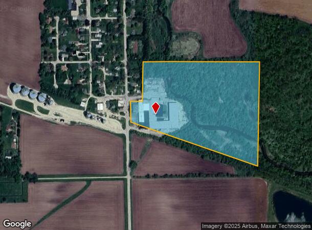
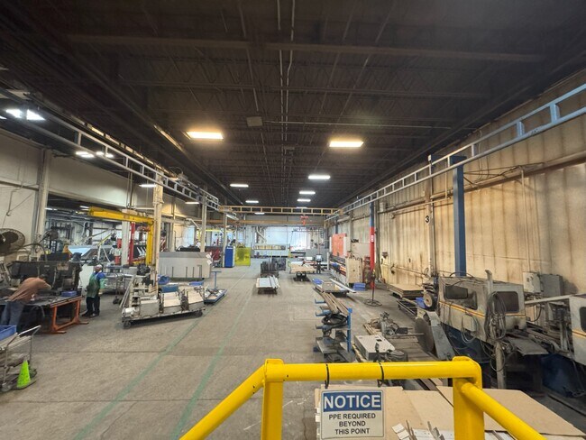
Property Record
127 S Walnut St, Lindenwood, IL 61049
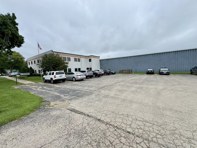
This Property Is For Sale
NEARBY LISTINGS FOR SALE OR LEASE
-
-
View all Lindenwood listings for sale on LoopNet.com
Property Detail
127 S Walnut St
Rochelle, IL
RNG/BLK:2 TWP:41 SECT/LOT:5 W 1329FT S 1183FT SW4 SE4 & ALSO ALL BLK 5 & ADJ 4RD TR VIL-LINDENWOOD N RR BK 321 PG 117
19-05-400-001
Ogle
Industrialgeneral
Illinois
A
5
17141C0325D
29 AC
2024
I-39 Corr/Ogle Cnty
2024
Chicago
961001
DEMOGRAPHICS near 127 S Walnut St
1 Mile
3 Mile
5 Mile
2024 Total Population
520
757
4,399
2029 Population
532
770
4,415
Pop Growth 2024-2029
+ 2.31%
+ 1.72%
+ 0.36%
Average Age
42
42
39
2024 Total Households
207
300
1,602
HH Growth 2024-2029
+ 2.42%
+ 1.67%
+ 0.31%
Median Household Inc
$70,892
$71,841
$87,679
Avg Household Size
2.50
2.50
2.80
2024 Avg HH Vehicles
2.00
2.00
2.00
Median Home Value
$188,888
$188,461
$197,604
Median Year Built
1969
1971
1981
Nearby Places
- Restaurants
- Banks
- Shops
- Fitness
- Groceries
PUBLIC TRANSPORTATION
AIRPORT
Chicago/Rockford International
DRIVE
WALK
Distance
Chicago/Rockford International
26 min
13.6 mi
Freight Ports
Port Milwaukee
DRIVE
WALK
Distance
Port Milwaukee
133 min
106.5 mi
Nearby Properties
Address
Land Use
TOTAL SIZE
Lot Size
Zoning
Address
Land Use
TOTAL SIZE
Lot Size
Zoning
Address
Land Use
TOTAL SIZE
Lot Size
Zoning
158.12 AC
Address
Land Use
TOTAL SIZE
Lot Size
Zoning
5.48 AC
Address
Land Use
TOTAL SIZE
Lot Size
Zoning
180.82 AC
Address
Land Use
TOTAL SIZE
Lot Size
Zoning
44.50 AC
Address
Land Use
TOTAL SIZE
Lot Size
Zoning
205.71 AC
Address
Land Use
TOTAL SIZE
Lot Size
Zoning
152.96 AC
Address
Land Use
TOTAL SIZE
Lot Size
Zoning
254.17 AC
Address
Land Use
TOTAL SIZE
Lot Size
Zoning
110.30 AC
Address
Land Use
TOTAL SIZE
Lot Size
Zoning
16.09 AC
Address
Land Use
TOTAL SIZE
Lot Size
Zoning
Address
Land Use
TOTAL SIZE
Lot Size
Zoning
13.06 AC
Address
Land Use
TOTAL SIZE
Lot Size
Zoning
Address
Land Use
TOTAL SIZE
Lot Size
Zoning
Address
Land Use
TOTAL SIZE
Lot Size
Zoning
Address
Land Use
TOTAL SIZE
Lot Size
Zoning
Address
Land Use
TOTAL SIZE
Lot Size
Zoning
47.12 AC
Address
Land Use
TOTAL SIZE
Lot Size
Zoning
152.30 AC
Address
Land Use
TOTAL SIZE
Lot Size
Zoning
24.52 AC
Address
Land Use
TOTAL SIZE
Lot Size
Zoning
Address
Land Use
TOTAL SIZE
Lot Size
Zoning
Address
Land Use
TOTAL SIZE
Lot Size
Zoning
Address
Land Use
TOTAL SIZE
Lot Size
Zoning
137.95 AC
Address
Land Use
TOTAL SIZE
Lot Size
Zoning
Address
Land Use
TOTAL SIZE
Lot Size
Zoning
The World's #1 Commercial Real Estate Marketplace
Connect with us
© 2025 CoStar Group
The information above has been obtained from sources believed reliable. While we do not doubt its accuracy we have not verified it and make no guarantee, warranty or representation about it. It is your responsibility to independently confirm its accuracy and completeness. Any projections, opinions, assumptions, or estimates used are for example only and do not represent the current or future performance of the property. The value of this transaction to you depends on tax and other factors which should be evaluated by your tax, financial, and legal advisors. You and your advisors should conduct a careful, independent investigation of the property to determine to your satisfaction the suitability of the property for your needs.