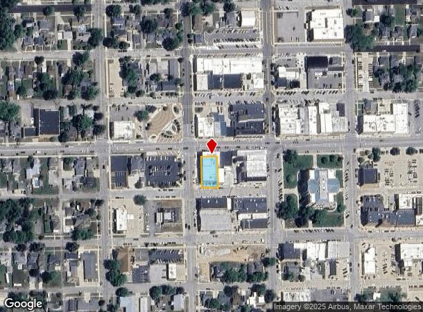
Property Record
127 W 7Th St, Auburn, IN 46706

NEARBY LISTINGS FOR SALE OR LEASE
-
-
View all Auburn listings for lease on LoopNet.com
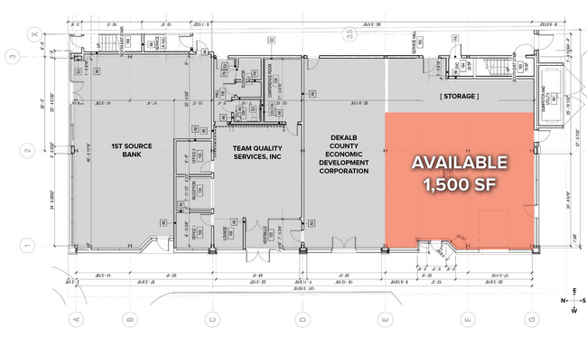
Property Detail
127 W 7Th St
Auburn, IN
City Auburn
17-06-32-126-001.000-025
OP LOT 13
Officebuilding
Dekalb
X
Indiana
18033C0231E
13
2024
0.21 AC
2024
Fort Wayne
020500
Other Market Areas
14,440 SF
DEMOGRAPHICS near 127 W 7Th St
1 Mile
3 Mile
5 Mile
2024 Total Population
7,579
16,641
27,911
2029 Population
7,812
17,158
28,741
Pop Growth 2024-2029
+ 3.07%
+ 3.11%
+ 2.97%
Average Age
39
41
40
2024 Total Households
3,135
6,871
11,103
HH Growth 2024-2029
+ 3.13%
+ 3.13%
+ 2.97%
Median Household Inc
$55,377
$59,655
$59,648
Avg Household Size
2.30
2.30
2.40
2024 Avg HH Vehicles
2.00
2.00
2.00
Median Home Value
$138,038
$156,913
$158,117
Median Year Built
1967
1981
1979
Nearby Places
- Restaurants
- Banks
- Shops
- Fitness
- Groceries
PUBLIC TRANSPORTATION
COMMUTER RAIL
Waterloo Amtrak Station (Capitol Limited - Amtrak, Lake Shore Limited - Amtrak)
DRIVE
WALK
Distance
Waterloo Amtrak Station (Capitol Limited - Amtrak, Lake Shore Limited - Amtrak)
9 min
5.0 mi
AIRPORT
Fort Wayne International
DRIVE
WALK
Distance
Fort Wayne International
47 min
36.3 mi
Freight Ports
Port of Toledo
DRIVE
WALK
Distance
Port of Toledo
136 min
97.1 mi
SALE & LEASE HISTORY
LISTING DATE
SALE/LEASE

Apr 05, 2022
For Lease
Nearby Properties
Address
Land Use
TOTAL SIZE
Lot Size
Zoning
Address
Land Use
TOTAL SIZE
Lot Size
Zoning
77,765 SF
24.02 AC
Address
Land Use
TOTAL SIZE
Lot Size
Zoning
406,797 SF
158.80 AC
Address
Land Use
TOTAL SIZE
Lot Size
Zoning
320,870 SF
106.40 AC
Address
Land Use
TOTAL SIZE
Lot Size
Zoning
59,049 SF
12.73 AC
Address
Land Use
TOTAL SIZE
Lot Size
Zoning
180,835 SF
18.82 AC
Address
Land Use
TOTAL SIZE
Lot Size
Zoning
186,496 SF
29.28 AC
Address
Land Use
TOTAL SIZE
Lot Size
Zoning
12,000 SF
159.44 AC
Address
Land Use
TOTAL SIZE
Lot Size
Zoning
15,960 SF
3.09 AC
Address
Land Use
TOTAL SIZE
Lot Size
Zoning
123,126 SF
15 AC
Address
Land Use
TOTAL SIZE
Lot Size
Zoning
13,200 SF
49.95 AC
Address
Land Use
TOTAL SIZE
Lot Size
Zoning
26,488 SF
12.12 AC
Address
Land Use
TOTAL SIZE
Lot Size
Zoning
400 SF
7.70 AC
Address
Land Use
TOTAL SIZE
Lot Size
Zoning
6,000 SF
42.17 AC
Address
Land Use
TOTAL SIZE
Lot Size
Zoning
37,152 SF
7.81 AC
Address
Land Use
TOTAL SIZE
Lot Size
Zoning
130,185 SF
34.82 AC
Address
Land Use
TOTAL SIZE
Lot Size
Zoning
28,390 SF
0.09 AC
Address
Land Use
TOTAL SIZE
Lot Size
Zoning
18,976 SF
4.13 AC
Address
Land Use
TOTAL SIZE
Lot Size
Zoning
50,876 SF
4.04 AC
Address
Land Use
TOTAL SIZE
Lot Size
Zoning
45,874 SF
3.94 AC
Address
Land Use
TOTAL SIZE
Lot Size
Zoning
95,148 SF
14.02 AC
Address
Land Use
TOTAL SIZE
Lot Size
Zoning
87,840 SF
7.12 AC
Address
Land Use
TOTAL SIZE
Lot Size
Zoning
14,760 SF
6.54 AC
Address
Land Use
TOTAL SIZE
Lot Size
Zoning
14,294 SF
80 AC
Address
Land Use
TOTAL SIZE
Lot Size
Zoning
5,184 SF
113.45 AC
Address
Land Use
TOTAL SIZE
Lot Size
Zoning
103,888 SF
30 AC
Address
Land Use
TOTAL SIZE
Lot Size
Zoning
4,048 SF
14.92 AC
Address
Land Use
TOTAL SIZE
Lot Size
Zoning
75,878 SF
1.05 AC
Address
Land Use
TOTAL SIZE
Lot Size
Zoning
20,420 SF
4.70 AC
Address
Land Use
TOTAL SIZE
Lot Size
Zoning
38,708 SF
1.55 AC
Address
Land Use
TOTAL SIZE
Lot Size
Zoning
22,000 SF
7.90 AC
The World's #1 Commercial Real Estate Marketplace
Connect with us
© 2025 CoStar Group
The information above has been obtained from sources believed reliable. While we do not doubt its accuracy we have not verified it and make no guarantee, warranty or representation about it. It is your responsibility to independently confirm its accuracy and completeness. Any projections, opinions, assumptions, or estimates used are for example only and do not represent the current or future performance of the property. The value of this transaction to you depends on tax and other factors which should be evaluated by your tax, financial, and legal advisors. You and your advisors should conduct a careful, independent investigation of the property to determine to your satisfaction the suitability of the property for your needs.