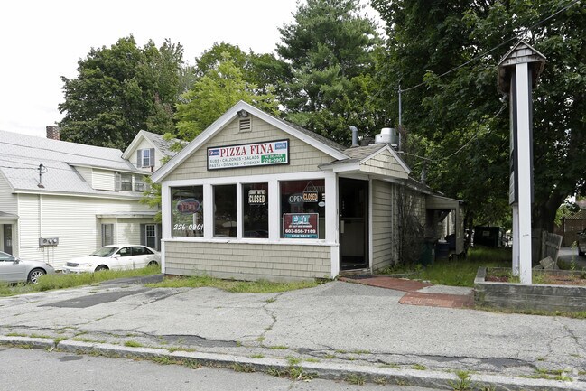
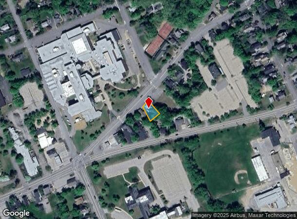
Property Record
127 Warren St, Concord, NH 03301

NEARBY LISTINGS FOR SALE OR LEASE
Property Detail
127 Warren St
Publicschool
Merrimack
X
New Hampshire
33013C0533E
7
2023
0.13 AC
2024
Other Market Areas
032500
Concord, NH
1,595 SF
CNCD-000040-000005-000007
DEMOGRAPHICS near 127 Warren St
1 Mile
3 Mile
5 Mile
2024 Total Population
12,378
26,724
47,232
2029 Population
12,993
27,995
49,651
Pop Growth 2024-2029
+ 4.97%
+ 4.76%
+ 5.12%
Average Age
42
43
43
2024 Total Households
5,548
11,567
19,352
HH Growth 2024-2029
+ 5.08%
+ 4.88%
+ 5.20%
Median Household Inc
$66,335
$68,238
$80,533
Avg Household Size
2.10
2.10
2.20
2024 Avg HH Vehicles
2.00
2.00
2.00
Median Home Value
$331,917
$291,425
$312,189
Median Year Built
1947
1960
1974
Nearby Places
Map Layers
Map Styles
 Street
 Aerial
- Restaurants
- Banks
- Shops
- Fitness
- Groceries
PUBLIC TRANSPORTATION
AIRPORT
Manchester Boston Regional
DRIVE
WALK
Distance
Manchester Boston Regional
38 min
23.6 mi
Freight Ports
Port of Boston
DRIVE
WALK
Distance
Port of Boston
103 min
72.2 mi
SALE & LEASE HISTORY
LISTING DATE
SALE/LEASE

Oct 11, 2017
For Sale
Nov 01, 2017
For Lease
Nearby Properties
Address
Land Use
TOTAL SIZE
Lot Size
Zoning
Address
Land Use
TOTAL SIZE
Lot Size
Zoning
392 AC
IS
Address
Land Use
TOTAL SIZE
Lot Size
Zoning
196 AC
IS
Address
Land Use
TOTAL SIZE
Lot Size
Zoning
181,592 SF
5.53 AC
IS
Address
Land Use
TOTAL SIZE
Lot Size
Zoning
7.22 AC
IS
Address
Land Use
TOTAL SIZE
Lot Size
Zoning
230,929 SF
127 AC
IS
Address
Land Use
TOTAL SIZE
Lot Size
Zoning
293,984 SF
IS
Address
Land Use
TOTAL SIZE
Lot Size
Zoning
156 AC
IS
Address
Land Use
TOTAL SIZE
Lot Size
Zoning
45.40 AC
RO
Address
Land Use
TOTAL SIZE
Lot Size
Zoning
128.74 AC
IS
Address
Land Use
TOTAL SIZE
Lot Size
Zoning
15.59 AC
GWP
Address
Land Use
TOTAL SIZE
Lot Size
Zoning
20 AC
RH
Address
Land Use
TOTAL SIZE
Lot Size
Zoning
10.48 AC
IS
Address
Land Use
TOTAL SIZE
Lot Size
Zoning
1.92 AC
IS
Address
Land Use
TOTAL SIZE
Lot Size
Zoning
79,703 SF
2.16 AC
CVP
Address
Land Use
TOTAL SIZE
Lot Size
Zoning
88,452 SF
1.12 AC
IS
Address
Land Use
TOTAL SIZE
Lot Size
Zoning
110 AC
IN
Address
Land Use
TOTAL SIZE
Lot Size
Zoning
75,917 SF
0.30 AC
CBP
Address
Land Use
TOTAL SIZE
Lot Size
Zoning
13.23 AC
RH
Address
Land Use
TOTAL SIZE
Lot Size
Zoning
21.45 AC
RH
Address
Land Use
TOTAL SIZE
Lot Size
Zoning
15.22 AC
OCP
Address
Land Use
TOTAL SIZE
Lot Size
Zoning
1.34 AC
CVP
Address
Land Use
TOTAL SIZE
Lot Size
Zoning
89,791 SF
4.56 AC
IS
Address
Land Use
TOTAL SIZE
Lot Size
Zoning
146,511 SF
19.85 AC
RS
Address
Land Use
TOTAL SIZE
Lot Size
Zoning
41.95 AC
IN
Address
Land Use
TOTAL SIZE
Lot Size
Zoning
26.72 AC
IN
Address
Land Use
TOTAL SIZE
Lot Size
Zoning
13 AC
IS
Address
Land Use
TOTAL SIZE
Lot Size
Zoning
34.94 AC
RM
Address
Land Use
TOTAL SIZE
Lot Size
Zoning
136,536 SF
17.69 AC
GWP
Address
Land Use
TOTAL SIZE
Lot Size
Zoning
109,643 SF
128.35 AC
IS
Address
Land Use
TOTAL SIZE
Lot Size
Zoning
52,750 SF
3.26 AC
OCP
The World's #1 Commercial Real Estate Marketplace
Connect with us
© 2026 CoStar Group
The information above has been obtained from sources believed reliable. While we do not doubt its accuracy we have not verified it and make no guarantee, warranty or representation about it. It is your responsibility to independently confirm its accuracy and completeness. Any projections, opinions, assumptions, or estimates used are for example only and do not represent the current or future performance of the property. The value of this transaction to you depends on tax and other factors which should be evaluated by your tax, financial, and legal advisors. You and your advisors should conduct a careful, independent investigation of the property to determine to your satisfaction the suitability of the property for your needs.