Property Record
127 Weakley Way Rd, Pinehurst, TX 77362

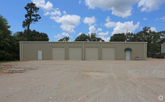
Property Detail
127 Weakley Way Rd
7510-03-00700
OAK HILL ACRES 03, LOT 7, ACRES 0.460
Commercialnec
Montgomery
2
Texas
B and X Area of moderate flood hazard, usually the area between the limits of the 100-year and 500-year floods.
7
2024
0.46 AC
2025
Northwest Hwy 6
690207
Houston
5,600 SF
Houston-Pasadena-The Woodlands, TX
NEARBY LISTINGS FOR SALE OR LEASE
DEMOGRAPHICS near 127 Weakley Way Rd
1 mile
3 mile
5 mile
2024 Total Population
2,724
19,419
60,107
2029 Population
3,243
22,881
70,609
Pop Growth 2024-2029
+ 19.05%
+ 17.83%
+ 17.47%
Average Age
40
39
39
2024 Total Households
909
6,480
20,071
HH Growth 2024-2029
+ 19.58%
+ 18.38%
+ 17.92%
Median Household Inc
$139,285
$87,306
$102,027
Avg Household Size
2.90
2.90
2.90
2024 Avg HH Vehicles
2.00
2.00
2.00
Median Home Value
$551,136
$436,463
$426,738
Median Year Built
2010
2006
2006
Nearby Places
Map Layers
Map Styles
 Street
 Aerial
Transit
 Traffic
 Biking
Places
Listings with unknown addresses are not visible on the map
- Restaurants
- Banks
- Shops
- Fitness
- Groceries
PUBLIC TRANSPORTATION
AIRPORT
George Bush Intcntl/Houston
Drive
Walk
Distance
George Bush Intcntl/Houston
41 min
33.3 mi
Freight Ports
Port of Houston
Drive
Walk
Distance
Port of Houston
61 min
43.9 mi
SALE & LEASE HISTORY
LISTING DATE
SALE/LEASE

Jan 30, 2019
For Lease
Aug 24, 2017
For Lease
Nearby Properties
Address
Land Use
TOTAL SIZE
Lot Size
Zoning
Address
Land Use
TOTAL SIZE
Lot Size
Zoning
14,865 SF
1.98 AC
2
Address
Land Use
TOTAL SIZE
Lot Size
Zoning
90,311 SF
10 AC
Address
Land Use
TOTAL SIZE
Lot Size
Zoning
32,624 SF
7.54 AC
Address
Land Use
TOTAL SIZE
Lot Size
Zoning
100,389 SF
5.47 AC
2
Address
Land Use
TOTAL SIZE
Lot Size
Zoning
55,247 SF
10.38 AC
Address
Land Use
TOTAL SIZE
Lot Size
Zoning
103,710 SF
7.50 AC
2
Address
Land Use
TOTAL SIZE
Lot Size
Zoning
68,950 SF
18.57 AC
2
Address
Land Use
TOTAL SIZE
Lot Size
Zoning
55,656 SF
5.09 AC
2
Address
Land Use
TOTAL SIZE
Lot Size
Zoning
1,722 SF
31.19 AC
2
Address
Land Use
TOTAL SIZE
Lot Size
Zoning
48,444 SF
9.55 AC
Address
Land Use
TOTAL SIZE
Lot Size
Zoning
25,050 SF
2.16 AC
Address
Land Use
TOTAL SIZE
Lot Size
Zoning
43,400 SF
6.05 AC
2
Address
Land Use
TOTAL SIZE
Lot Size
Zoning
13,280 SF
4 AC
Address
Land Use
TOTAL SIZE
Lot Size
Zoning
5,353 SF
37.56 AC
Address
Land Use
TOTAL SIZE
Lot Size
Zoning
4,365 SF
0.99 AC
Address
Land Use
TOTAL SIZE
Lot Size
Zoning
13,545 SF
4.56 AC
2
Address
Land Use
TOTAL SIZE
Lot Size
Zoning
52,800 SF
3.81 AC
2
Address
Land Use
TOTAL SIZE
Lot Size
Zoning
10,500 SF
1.64 AC
Address
Land Use
TOTAL SIZE
Lot Size
Zoning
8,958 SF
40.19 AC
2
Address
Land Use
TOTAL SIZE
Lot Size
Zoning
11,723 SF
2.50 AC
2
Address
Land Use
TOTAL SIZE
Lot Size
Zoning
34,400 SF
5 AC
Address
Land Use
TOTAL SIZE
Lot Size
Zoning
37,512 SF
9.91 AC
2
Address
Land Use
TOTAL SIZE
Lot Size
Zoning
13,871 SF
1.68 AC
2
Address
Land Use
TOTAL SIZE
Lot Size
Zoning
27,450 SF
2.08 AC
Address
Land Use
TOTAL SIZE
Lot Size
Zoning
31,627 SF
11.46 AC
Address
Land Use
TOTAL SIZE
Lot Size
Zoning
44,301 SF
4.23 AC
2
Address
Land Use
TOTAL SIZE
Lot Size
Zoning
24,000 SF
1 AC
Address
Land Use
TOTAL SIZE
Lot Size
Zoning
13,260 SF
2.41 AC
2
Address
Land Use
TOTAL SIZE
Lot Size
Zoning
8,320 SF
1.37 AC
Address
Land Use
TOTAL SIZE
Lot Size
Zoning
8,650 SF
1.19 AC
The World's #1 Commercial Real Estate Marketplace
Connect with us
© 2026 CoStar Group
The information above has been obtained from sources believed reliable. While we do not doubt its accuracy we have not verified it and make no guarantee, warranty or representation about it. It is your responsibility to independently confirm its accuracy and completeness. Any projections, opinions, assumptions, or estimates used are for example only and do not represent the current or future performance of the property. The value of this transaction to you depends on tax and other factors which should be evaluated by your tax, financial, and legal advisors. You and your advisors should conduct a careful, independent investigation of the property to determine to your satisfaction the suitability of the property for your needs.