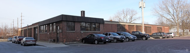
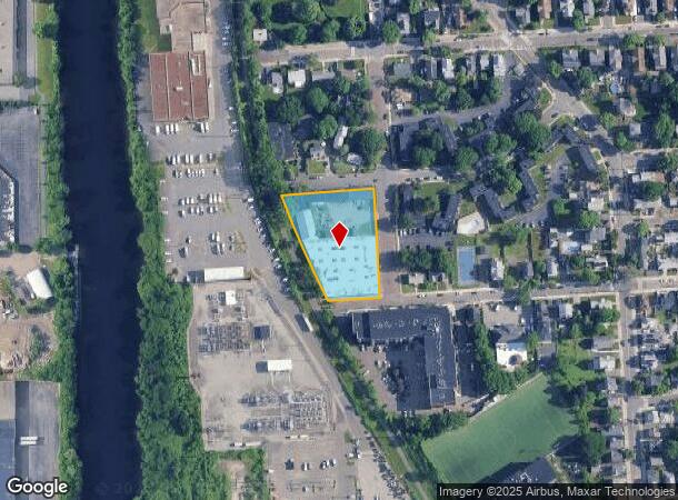
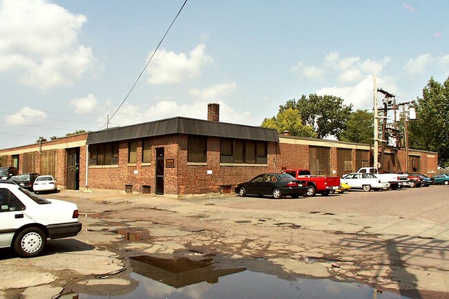
Property Record
127 Wyllis Ave, Malden, MA 02148
NEARBY LISTINGS FOR SALE OR LEASE
Property Detail
127 Wyllis Ave
MALD-000060-000244-000402
Middlesex
Manufacturinglight
Massachusetts
X
402
25017C0437F
1.33 AC
2025
Medford/Malden
2025
Boston
341400
Boston-Cambridge-Newton, MA-NH
25,575 SF
DEMOGRAPHICS near 127 Wyllis Ave
1 Mile
3 Mile
5 Mile
2024 Total Population
44,654
305,937
733,086
2029 Population
43,274
295,146
712,121
Pop Growth 2024-2029
(3.09%)
(3.53%)
(2.86%)
Average Age
37
38
38
2024 Total Households
17,612
119,738
304,623
HH Growth 2024-2029
(2.84%)
(3.56%)
(2.91%)
Median Household Inc
$78,622
$91,389
$100,976
Avg Household Size
2.50
2.40
2.20
2024 Avg HH Vehicles
1.00
1.00
1.00
Median Home Value
$641,018
$671,564
$755,898
Median Year Built
1949
1948
1949
Nearby Places
Map Layers
Map Styles
 Street
 Aerial
- Restaurants
- Banks
- Shops
- Fitness
- Groceries
PUBLIC TRANSPORTATION
COMMUTER RAIL
Malden Center (Haverhill Line - Massachusetts Bay Transportation Authority Commuter Rail (Purple Line))
DRIVE
WALK
Distance
Malden Center (Haverhill Line - Massachusetts Bay Transportation Authority Commuter Rail (Purple Line))
4 min
19 min
1.0 mi
DRIVE
WALK
Distance
7 min
2.7 mi
AIRPORT
General Edward Lawrence Logan International
DRIVE
WALK
Distance
General Edward Lawrence Logan International
14 min
6.1 mi
Freight Ports
Port of Boston
DRIVE
WALK
Distance
Port of Boston
17 min
7.8 mi
Nearby Properties
Address
Land Use
TOTAL SIZE
Lot Size
Zoning
Address
Land Use
TOTAL SIZE
Lot Size
Zoning
47.67 AC
UN
Address
Land Use
TOTAL SIZE
Lot Size
Zoning
646,546 SF
89.28 AC
ROD
Address
Land Use
TOTAL SIZE
Lot Size
Zoning
386,825 SF
10.67 AC
Address
Land Use
TOTAL SIZE
Lot Size
Zoning
569,990 SF
0.46 AC
HR
Address
Land Use
TOTAL SIZE
Lot Size
Zoning
410,642 SF
4.68 AC
CTED
Address
Land Use
TOTAL SIZE
Lot Size
Zoning
43.90 AC
Address
Land Use
TOTAL SIZE
Lot Size
Zoning
234,450 SF
3.49 AC
I
Address
Land Use
TOTAL SIZE
Lot Size
Zoning
297,396 SF
2.79 AC
CTED
Address
Land Use
TOTAL SIZE
Lot Size
Zoning
424,000 SF
2.63 AC
RC
Address
Land Use
TOTAL SIZE
Lot Size
Zoning
378,339 SF
3.02 AC
E
Address
Land Use
TOTAL SIZE
Lot Size
Zoning
Address
Land Use
TOTAL SIZE
Lot Size
Zoning
530,113 SF
29.43 AC
Address
Land Use
TOTAL SIZE
Lot Size
Zoning
6.73 AC
HB
Address
Land Use
TOTAL SIZE
Lot Size
Zoning
13.48 AC
Address
Land Use
TOTAL SIZE
Lot Size
Zoning
324,870 SF
9.37 AC
E
Address
Land Use
TOTAL SIZE
Lot Size
Zoning
339,600 SF
23.09 AC
CIV
Address
Land Use
TOTAL SIZE
Lot Size
Zoning
254,075 SF
3.70 AC
Address
Land Use
TOTAL SIZE
Lot Size
Zoning
613,125 SF
15.74 AC
RC
Address
Land Use
TOTAL SIZE
Lot Size
Zoning
16.96 AC
UN
Address
Land Use
TOTAL SIZE
Lot Size
Zoning
21,024 SF
18.19 AC
Address
Land Use
TOTAL SIZE
Lot Size
Zoning
253,859 SF
3.18 AC
Address
Land Use
TOTAL SIZE
Lot Size
Zoning
454,752 SF
6.22 AC
Address
Land Use
TOTAL SIZE
Lot Size
Zoning
7,736 SF
24.56 AC
UR
Address
Land Use
TOTAL SIZE
Lot Size
Zoning
129,898 SF
43.82 AC
ID
Address
Land Use
TOTAL SIZE
Lot Size
Zoning
Address
Land Use
TOTAL SIZE
Lot Size
Zoning
0.52 AC
C
Address
Land Use
TOTAL SIZE
Lot Size
Zoning
359,892 SF
9.06 AC
Address
Land Use
TOTAL SIZE
Lot Size
Zoning
196,495 SF
0.70 AC
TOD100
Address
Land Use
TOTAL SIZE
Lot Size
Zoning
252,796 SF
2.46 AC
ASMD
Address
Land Use
TOTAL SIZE
Lot Size
Zoning
273,180 SF
6.53 AC
CI
The World's #1 Commercial Real Estate Marketplace
Connect with us
© 2025 CoStar Group
The information above has been obtained from sources believed reliable. While we do not doubt its accuracy we have not verified it and make no guarantee, warranty or representation about it. It is your responsibility to independently confirm its accuracy and completeness. Any projections, opinions, assumptions, or estimates used are for example only and do not represent the current or future performance of the property. The value of this transaction to you depends on tax and other factors which should be evaluated by your tax, financial, and legal advisors. You and your advisors should conduct a careful, independent investigation of the property to determine to your satisfaction the suitability of the property for your needs.