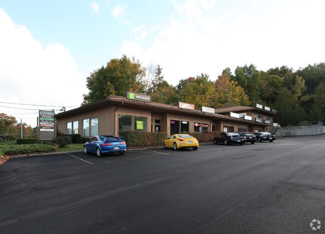
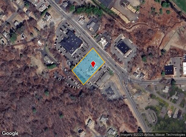
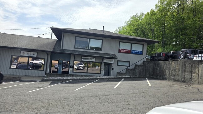
Property Record
1258 Main St, Watertown, CT 06795
Current Lease Availabilities
NEARBY LISTINGS FOR SALE OR LEASE
Property Detail
1258 Main St
Torrington, CT
Litchfield
WATE-000121-000084-000022C
Connecticut
Restaurantbuilding
22c
2025
1.23 AC
2025
New Milford/SW Litchfield
360200
Hartford
2,634 SF
DEMOGRAPHICS near 1258 Main St
1 Mile
3 Mile
5 Mile
2024 Total Population
6,277
34,541
104,190
2029 Population
6,218
34,423
103,837
Pop Growth 2024-2029
(0.94%)
(0.34%)
(0.34%)
Average Age
43
42
39
2024 Total Households
2,502
13,407
40,194
HH Growth 2024-2029
(0.88%)
(0.35%)
(0.32%)
Median Household Inc
$78,491
$76,165
$57,603
Avg Household Size
2.40
2.50
2.50
2024 Avg HH Vehicles
2.00
2.00
2.00
Median Home Value
$245,112
$238,255
$213,485
Median Year Built
1964
1966
1960
Nearby Places
Map Layers
Map Styles
 Street
 Aerial
- Restaurants
- Banks
- Shops
- Fitness
- Groceries
PUBLIC TRANSPORTATION
COMMUTER RAIL
Waterbury Station (New Haven Line - Metro-North Commuter Railroad Company (Metro-North))
DRIVE
WALK
Distance
Waterbury Station (New Haven Line - Metro-North Commuter Railroad Company (Metro-North))
13 min
5.5 mi
Naugatuck Station (New Haven Line - Metro-North Commuter Railroad Company (Metro-North))
DRIVE
WALK
Distance
Naugatuck Station (New Haven Line - Metro-North Commuter Railroad Company (Metro-North))
16 min
9.5 mi
AIRPORT
Bradley International
DRIVE
WALK
Distance
Bradley International
61 min
48.8 mi
Nearby Properties
Address
Land Use
TOTAL SIZE
Lot Size
Zoning
Address
Land Use
TOTAL SIZE
Lot Size
Zoning
196,057 SF
17 AC
RS
Address
Land Use
TOTAL SIZE
Lot Size
Zoning
75 AC
R20
Address
Land Use
TOTAL SIZE
Lot Size
Zoning
155,861 SF
13.70 AC
R125
Address
Land Use
TOTAL SIZE
Lot Size
Zoning
201,817 SF
34.84 AC
R125
Address
Land Use
TOTAL SIZE
Lot Size
Zoning
140,700 SF
25.55 AC
R30
Address
Land Use
TOTAL SIZE
Lot Size
Zoning
129,672 SF
8 AC
IG
Address
Land Use
TOTAL SIZE
Lot Size
Zoning
76,264 SF
15.03 AC
RS
Address
Land Use
TOTAL SIZE
Lot Size
Zoning
30.46 AC
RM
Address
Land Use
TOTAL SIZE
Lot Size
Zoning
72,336 SF
15.39 AC
R30
Address
Land Use
TOTAL SIZE
Lot Size
Zoning
70.40 AC
R70
Address
Land Use
TOTAL SIZE
Lot Size
Zoning
24.60 AC
RM
Address
Land Use
TOTAL SIZE
Lot Size
Zoning
54,820 SF
1.03 AC
CA
Address
Land Use
TOTAL SIZE
Lot Size
Zoning
209.81 AC
R125
Address
Land Use
TOTAL SIZE
Lot Size
Zoning
326,357 SF
53.34 AC
IR200
Address
Land Use
TOTAL SIZE
Lot Size
Zoning
84,480 SF
11.06 AC
BSC
Address
Land Use
TOTAL SIZE
Lot Size
Zoning
78,530 SF
20.98 AC
BSC
Address
Land Use
TOTAL SIZE
Lot Size
Zoning
12.45 AC
RM
Address
Land Use
TOTAL SIZE
Lot Size
Zoning
60,703 SF
6.60 AC
R125
Address
Land Use
TOTAL SIZE
Lot Size
Zoning
47.80 AC
RS
Address
Land Use
TOTAL SIZE
Lot Size
Zoning
13.12 AC
CA40
Address
Land Use
TOTAL SIZE
Lot Size
Zoning
13.52 AC
RM
Address
Land Use
TOTAL SIZE
Lot Size
Zoning
216,200 SF
12.43 AC
IG
Address
Land Use
TOTAL SIZE
Lot Size
Zoning
39,169 SF
1.28 AC
RL
Address
Land Use
TOTAL SIZE
Lot Size
Zoning
178,860 SF
52.98 AC
IR200
Address
Land Use
TOTAL SIZE
Lot Size
Zoning
14.98 AC
IR200
Address
Land Use
TOTAL SIZE
Lot Size
Zoning
3.86 AC
RM
Address
Land Use
TOTAL SIZE
Lot Size
Zoning
44,730 SF
4.25 AC
RM
Address
Land Use
TOTAL SIZE
Lot Size
Zoning
182,765 SF
9.08 AC
IG20F
Address
Land Use
TOTAL SIZE
Lot Size
Zoning
3.35 AC
BSC
Address
Land Use
TOTAL SIZE
Lot Size
Zoning
212,155 SF
12.70 AC
IG
The World's #1 Commercial Real Estate Marketplace
Connect with us
© 2025 CoStar Group
The information above has been obtained from sources believed reliable. While we do not doubt its accuracy we have not verified it and make no guarantee, warranty or representation about it. It is your responsibility to independently confirm its accuracy and completeness. Any projections, opinions, assumptions, or estimates used are for example only and do not represent the current or future performance of the property. The value of this transaction to you depends on tax and other factors which should be evaluated by your tax, financial, and legal advisors. You and your advisors should conduct a careful, independent investigation of the property to determine to your satisfaction the suitability of the property for your needs.