Property Record
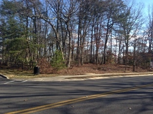
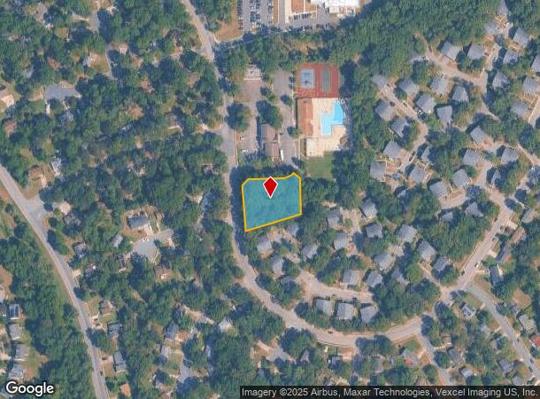
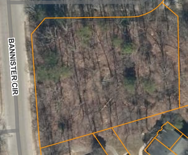
1270 Bannister Cir, Waldorf, MD 20602
This Property Is For Sale
NEARBY LISTINGS FOR SALE OR LEASE
Property Detail
1270 Bannister Cir
Washington-Arlington-Alexandria, DC-VA-MD-WV
St Charles Sub
06-075797
.70 AC PARCEL C ST CHARLES SUB-ADJ BANN
Commercialnec
Charles
X
Maryland
24017C0185C
0.70 AC
2025
Charles County
2025
Washington, DC
850906
DEMOGRAPHICS near 1270 Bannister Cir
1 Mile
3 Mile
5 Mile
2024 Total Population
13,978
49,363
93,626
2029 Population
14,574
51,670
97,867
Pop Growth 2024-2029
+ 4.26%
+ 4.67%
+ 4.53%
Average Age
37
37
38
2024 Total Households
5,154
18,206
33,536
HH Growth 2024-2029
+ 4.31%
+ 4.65%
+ 4.51%
Median Household Inc
$90,741
$96,456
$103,003
Avg Household Size
2.60
2.60
2.70
2024 Avg HH Vehicles
2.00
2.00
2.00
Median Home Value
$308,666
$336,980
$354,257
Median Year Built
1983
1992
1991
Nearby Places
- Restaurants
- Banks
- Shops
- Fitness
- Groceries
PUBLIC TRANSPORTATION
AIRPORT
Ronald Reagan Washington Ntl
DRIVE
WALK
Distance
Ronald Reagan Washington Ntl
49 min
30.1 mi
Freight Ports
Port of Baltimore
DRIVE
WALK
Distance
Port of Baltimore
84 min
56.9 mi
Nearby Properties
Address
Land Use
TOTAL SIZE
Lot Size
Zoning
Address
Land Use
TOTAL SIZE
Lot Size
Zoning
714,134 SF
29.53 AC
PUD
Address
Land Use
TOTAL SIZE
Lot Size
Zoning
289,883 SF
98.95 AC
PUD
Address
Land Use
TOTAL SIZE
Lot Size
Zoning
477,958 SF
47.50 AC
CB
Address
Land Use
TOTAL SIZE
Lot Size
Zoning
287,760 SF
16.27 AC
PUD
Address
Land Use
TOTAL SIZE
Lot Size
Zoning
250,272 SF
12.37 AC
PUD
Address
Land Use
TOTAL SIZE
Lot Size
Zoning
312,478 SF
54.26 AC
PUD
Address
Land Use
TOTAL SIZE
Lot Size
Zoning
239,608 SF
11.28 AC
PUD
Address
Land Use
TOTAL SIZE
Lot Size
Zoning
392,124 SF
38.73 AC
PUD
Address
Land Use
TOTAL SIZE
Lot Size
Zoning
265,637 SF
54.72 AC
RH
Address
Land Use
TOTAL SIZE
Lot Size
Zoning
206,966 SF
32.61 AC
CB
Address
Land Use
TOTAL SIZE
Lot Size
Zoning
262,779 SF
26.84 AC
CB
Address
Land Use
TOTAL SIZE
Lot Size
Zoning
136,192 SF
17.85 AC
PUD
Address
Land Use
TOTAL SIZE
Lot Size
Zoning
239,208 SF
13.51 AC
PUD
Address
Land Use
TOTAL SIZE
Lot Size
Zoning
237,903 SF
16.03 AC
PRD
Address
Land Use
TOTAL SIZE
Lot Size
Zoning
207,928 SF
15.50 AC
PUD
Address
Land Use
TOTAL SIZE
Lot Size
Zoning
141,578 SF
7.40 AC
PUD
Address
Land Use
TOTAL SIZE
Lot Size
Zoning
42.74 AC
PUD
Address
Land Use
TOTAL SIZE
Lot Size
Zoning
160,985 SF
24.85 AC
CB
Address
Land Use
TOTAL SIZE
Lot Size
Zoning
143,728 SF
19.71 AC
CB
Address
Land Use
TOTAL SIZE
Lot Size
Zoning
86,880 SF
22.18 AC
PUD
Address
Land Use
TOTAL SIZE
Lot Size
Zoning
194,972 SF
59.84 AC
RH
Address
Land Use
TOTAL SIZE
Lot Size
Zoning
145,749 SF
20.15 AC
PUD
Address
Land Use
TOTAL SIZE
Lot Size
Zoning
118,880 SF
3.78 AC
PUD
Address
Land Use
TOTAL SIZE
Lot Size
Zoning
121,968 SF
2.23 AC
PUD
Address
Land Use
TOTAL SIZE
Lot Size
Zoning
109,304 SF
9.09 AC
PUD
Address
Land Use
TOTAL SIZE
Lot Size
Zoning
53,318 SF
20.01 AC
PUD
Address
Land Use
TOTAL SIZE
Lot Size
Zoning
147,800 SF
4.54 AC
RH
Address
Land Use
TOTAL SIZE
Lot Size
Zoning
84,240 SF
16.46 AC
PUD
Address
Land Use
TOTAL SIZE
Lot Size
Zoning
19,422 SF
76.18 AC
PUD
Address
Land Use
TOTAL SIZE
Lot Size
Zoning
116,828 SF
10.78 AC
PUD
The World's #1 Commercial Real Estate Marketplace
Connect with us
© 2025 CoStar Group
The information above has been obtained from sources believed reliable. While we do not doubt its accuracy we have not verified it and make no guarantee, warranty or representation about it. It is your responsibility to independently confirm its accuracy and completeness. Any projections, opinions, assumptions, or estimates used are for example only and do not represent the current or future performance of the property. The value of this transaction to you depends on tax and other factors which should be evaluated by your tax, financial, and legal advisors. You and your advisors should conduct a careful, independent investigation of the property to determine to your satisfaction the suitability of the property for your needs.