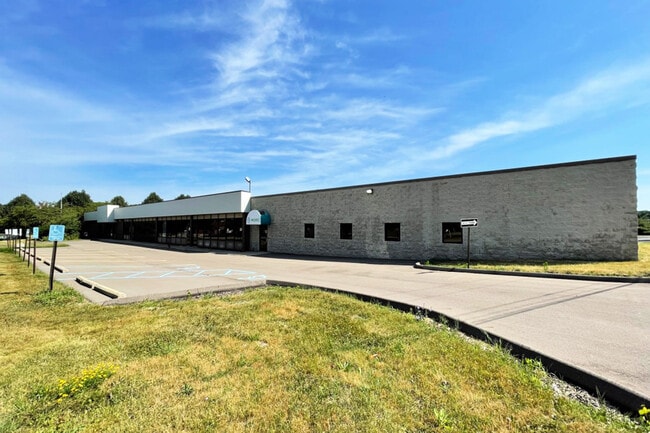
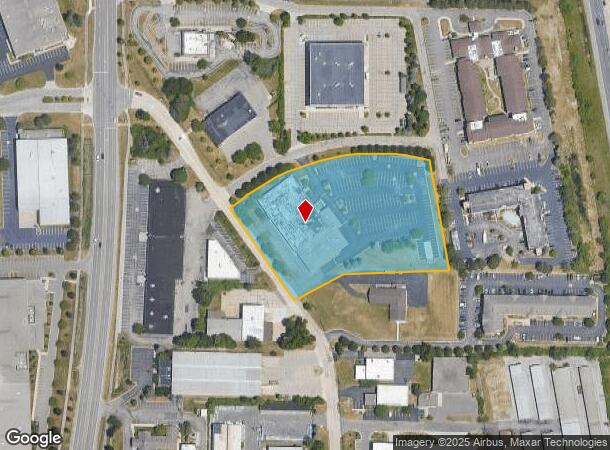
Property Record
1270 Doris Rd, Auburn Hills, MI 48326

Current Lease Availabilities
NEARBY LISTINGS FOR SALE OR LEASE
Property Detail
1270 Doris Rd
14-23-178-007
T3N, R10E, SEC 23 PART OF NW 1/4 BEG AT PT DIST N 86-55-00 W 952.60 FT & N 34-35-00 W 176.46 FT FROM CEN OF SEC, TH N 34-35-00 W 334.16 FT, TH N 55-25-00 E 60.00 FT, TH ALG CURVE CONCAVE SLY, RAD 630.43 FT, CHORD BEARS N 80-40-40 E 538.05 FT, DIST OF
Officebuilding
Oakland
X
Michigan
26125C0386F
4.05 AC
2024
Auburn Hills, Pontiac & Rochester
2024
Detroit
981500
Detroit-Warren-Dearborn, MI
32,851 SF
DEMOGRAPHICS near 1270 Doris Rd
1 Mile
3 Mile
5 Mile
2024 Total Population
3,579
64,324
164,018
2029 Population
3,562
64,266
163,422
Pop Growth 2024-2029
(0.47%)
(0.09%)
(0.36%)
Average Age
35
37
40
2024 Total Households
1,395
25,502
64,848
HH Growth 2024-2029
(0.57%)
(0.16%)
(0.37%)
Median Household Inc
$34,338
$53,264
$71,540
Avg Household Size
2.50
2.30
2.40
2024 Avg HH Vehicles
2.00
2.00
2.00
Median Home Value
$94,816
$151,236
$293,288
Median Year Built
1958
1973
1974
Nearby Places
- Restaurants
- Banks
- Shops
- Fitness
- Groceries
PUBLIC TRANSPORTATION
COMMUTER RAIL
DRIVE
WALK
Distance
9 min
4.2 mi
AIRPORT
Windsor International
DRIVE
WALK
Distance
Windsor International
58 min
39.1 mi
Bishop International
DRIVE
WALK
Distance
Bishop International
56 min
39.8 mi
Detroit Metro Wayne County
DRIVE
WALK
Distance
Detroit Metro Wayne County
62 min
48.6 mi
Nearby Properties
Address
Land Use
TOTAL SIZE
Lot Size
Zoning
Address
Land Use
TOTAL SIZE
Lot Size
Zoning
7,879,586 SF
457.68 AC
TR
Address
Land Use
TOTAL SIZE
Lot Size
Zoning
2,734,739 SF
80.39 AC
Address
Land Use
TOTAL SIZE
Lot Size
Zoning
803,597 SF
67 AC
SP
Address
Land Use
TOTAL SIZE
Lot Size
Zoning
238,755 SF
Address
Land Use
TOTAL SIZE
Lot Size
Zoning
453,700 SF
Address
Land Use
TOTAL SIZE
Lot Size
Zoning
404,427 SF
28.15 AC
TR
Address
Land Use
TOTAL SIZE
Lot Size
Zoning
316,358 SF
20.89 AC
P
Address
Land Use
TOTAL SIZE
Lot Size
Zoning
337,992 SF
18.96 AC
TR
Address
Land Use
TOTAL SIZE
Lot Size
Zoning
104,434 SF
8.64 AC
Address
Land Use
TOTAL SIZE
Lot Size
Zoning
1,771,589 SF
96.73 AC
Address
Land Use
TOTAL SIZE
Lot Size
Zoning
430,338 SF
46.09 AC
Address
Land Use
TOTAL SIZE
Lot Size
Zoning
608,251 SF
50.49 AC
II
Address
Land Use
TOTAL SIZE
Lot Size
Zoning
238,755 SF
18.12 AC
Address
Land Use
TOTAL SIZE
Lot Size
Zoning
246,150 SF
26.64 AC
TR
Address
Land Use
TOTAL SIZE
Lot Size
Zoning
487,797 SF
34.74 AC
TR
Address
Land Use
TOTAL SIZE
Lot Size
Zoning
278,387 SF
43.37 AC
Address
Land Use
TOTAL SIZE
Lot Size
Zoning
210,000 SF
14.46 AC
TR
Address
Land Use
TOTAL SIZE
Lot Size
Zoning
337,992 SF
Address
Land Use
TOTAL SIZE
Lot Size
Zoning
430,338 SF
43.22 AC
Address
Land Use
TOTAL SIZE
Lot Size
Zoning
214,772 SF
Address
Land Use
TOTAL SIZE
Lot Size
Zoning
601,151 SF
Address
Land Use
TOTAL SIZE
Lot Size
Zoning
360,186 SF
38.44 AC
RM2
Address
Land Use
TOTAL SIZE
Lot Size
Zoning
101,568 SF
8.06 AC
Address
Land Use
TOTAL SIZE
Lot Size
Zoning
321,936 SF
29.11 AC
RM1
Address
Land Use
TOTAL SIZE
Lot Size
Zoning
278,387 SF
Address
Land Use
TOTAL SIZE
Lot Size
Zoning
64,217 SF
39.13 AC
Address
Land Use
TOTAL SIZE
Lot Size
Zoning
135,230 SF
Address
Land Use
TOTAL SIZE
Lot Size
Zoning
25,747 SF
2.95 AC
470
Address
Land Use
TOTAL SIZE
Lot Size
Zoning
174,019 SF
9.66 AC
Address
Land Use
TOTAL SIZE
Lot Size
Zoning
186,242 SF
The World's #1 Commercial Real Estate Marketplace
Connect with us
© 2025 CoStar Group
The information above has been obtained from sources believed reliable. While we do not doubt its accuracy we have not verified it and make no guarantee, warranty or representation about it. It is your responsibility to independently confirm its accuracy and completeness. Any projections, opinions, assumptions, or estimates used are for example only and do not represent the current or future performance of the property. The value of this transaction to you depends on tax and other factors which should be evaluated by your tax, financial, and legal advisors. You and your advisors should conduct a careful, independent investigation of the property to determine to your satisfaction the suitability of the property for your needs.