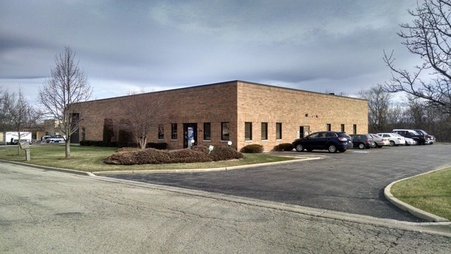
Property Record
1270 Kyle Ct, Wauconda, IL 60084


NEARBY LISTINGS FOR SALE OR LEASE
Property Detail
1270 Kyle Ct
Chicago-Naperville-Elgin, IL-IN-WI
Wauconda Industrial Park No. 2
09-23-201-060
WAUCONDA INDUSTRIAL PARK NO. 2;(EX SLY 17.45) LOT 9
Industrialgeneral
Lake
X
Illinois
17097C0117L
9
2023
1.15 AC
2024
South Lake County
864207
Chicago
17,115 SF
DEMOGRAPHICS near 1270 Kyle Ct
1 Mile
3 Mile
5 Mile
2024 Total Population
1,551
25,638
68,392
2029 Population
1,528
25,253
67,778
Pop Growth 2024-2029
(1.48%)
(1.50%)
(0.90%)
Average Age
41
40
41
2024 Total Households
585
9,486
25,689
HH Growth 2024-2029
(1.71%)
(1.53%)
(0.91%)
Median Household Inc
$94,589
$95,692
$97,814
Avg Household Size
2.60
2.70
2.60
2024 Avg HH Vehicles
2.00
2.00
2.00
Median Home Value
$226,744
$265,668
$274,861
Median Year Built
1978
1990
1993
Nearby Places
Map Layers
Map Styles
 Street
 Aerial
- Restaurants
- Banks
- Shops
- Fitness
- Groceries
PUBLIC TRANSPORTATION
COMMUTER RAIL
Round Lake Station (Milwaukee District North Line - Northeast Illinois Regional Commuter Railroad (Metra))
DRIVE
WALK
Distance
Round Lake Station (Milwaukee District North Line - Northeast Illinois Regional Commuter Railroad (Metra))
14 min
8.5 mi
Long Lake Station (Milwaukee District North Line - Northeast Illinois Regional Commuter Railroad (Metra))
DRIVE
WALK
Distance
Long Lake Station (Milwaukee District North Line - Northeast Illinois Regional Commuter Railroad (Metra))
14 min
9.0 mi
AIRPORT
Chicago O'Hare International
DRIVE
WALK
Distance
Chicago O'Hare International
67 min
34.7 mi
Freight Ports
Port Milwaukee
DRIVE
WALK
Distance
Port Milwaukee
82 min
63.7 mi
Nearby Properties
Address
Land Use
TOTAL SIZE
Lot Size
Zoning
Address
Land Use
TOTAL SIZE
Lot Size
Zoning
220,060 SF
11.75 AC
Address
Land Use
TOTAL SIZE
Lot Size
Zoning
68,132 SF
1.96 AC
Address
Land Use
TOTAL SIZE
Lot Size
Zoning
241,227 SF
15.79 AC
Address
Land Use
TOTAL SIZE
Lot Size
Zoning
163,715 SF
35.43 AC
Address
Land Use
TOTAL SIZE
Lot Size
Zoning
32.23 AC
Address
Land Use
TOTAL SIZE
Lot Size
Zoning
212,880 SF
20.06 AC
Address
Land Use
TOTAL SIZE
Lot Size
Zoning
114,186 SF
17.14 AC
Address
Land Use
TOTAL SIZE
Lot Size
Zoning
258,252 SF
1.97 AC
Address
Land Use
TOTAL SIZE
Lot Size
Zoning
118,869 SF
5.88 AC
Address
Land Use
TOTAL SIZE
Lot Size
Zoning
521,479 SF
6.20 AC
Address
Land Use
TOTAL SIZE
Lot Size
Zoning
1,525,750 SF
7.55 AC
Address
Land Use
TOTAL SIZE
Lot Size
Zoning
81,478 SF
9.25 AC
Address
Land Use
TOTAL SIZE
Lot Size
Zoning
326,933 SF
23.75 AC
Address
Land Use
TOTAL SIZE
Lot Size
Zoning
34,600 SF
2.91 AC
Address
Land Use
TOTAL SIZE
Lot Size
Zoning
54,572 SF
4.97 AC
Address
Land Use
TOTAL SIZE
Lot Size
Zoning
142,560 SF
8.02 AC
Address
Land Use
TOTAL SIZE
Lot Size
Zoning
100,000 SF
5.13 AC
Address
Land Use
TOTAL SIZE
Lot Size
Zoning
77,881 SF
4.60 AC
Address
Land Use
TOTAL SIZE
Lot Size
Zoning
10.55 AC
Address
Land Use
TOTAL SIZE
Lot Size
Zoning
26,896 SF
4.03 AC
Address
Land Use
TOTAL SIZE
Lot Size
Zoning
18,873 SF
159.95 AC
Address
Land Use
TOTAL SIZE
Lot Size
Zoning
123,948 SF
4 AC
Address
Land Use
TOTAL SIZE
Lot Size
Zoning
56,042 SF
1.15 AC
Address
Land Use
TOTAL SIZE
Lot Size
Zoning
4,256 SF
6.62 AC
Address
Land Use
TOTAL SIZE
Lot Size
Zoning
99,256 SF
2 AC
Address
Land Use
TOTAL SIZE
Lot Size
Zoning
56,566 SF
1.86 AC
Address
Land Use
TOTAL SIZE
Lot Size
Zoning
44,952 SF
3.26 AC
Address
Land Use
TOTAL SIZE
Lot Size
Zoning
163,800 SF
5 AC
Address
Land Use
TOTAL SIZE
Lot Size
Zoning
71,007 SF
7.02 AC
Address
Land Use
TOTAL SIZE
Lot Size
Zoning
70,062 SF
12.03 AC
The World's #1 Commercial Real Estate Marketplace
Connect with us
© 2026 CoStar Group
The information above has been obtained from sources believed reliable. While we do not doubt its accuracy we have not verified it and make no guarantee, warranty or representation about it. It is your responsibility to independently confirm its accuracy and completeness. Any projections, opinions, assumptions, or estimates used are for example only and do not represent the current or future performance of the property. The value of this transaction to you depends on tax and other factors which should be evaluated by your tax, financial, and legal advisors. You and your advisors should conduct a careful, independent investigation of the property to determine to your satisfaction the suitability of the property for your needs.