Property Record
1270 Reed Canal Rd, Port Orange, FL 32129

NEARBY LISTINGS FOR SALE OR LEASE
-
-
View all Port Orange listings for sale on LoopNet.com
Property Detail
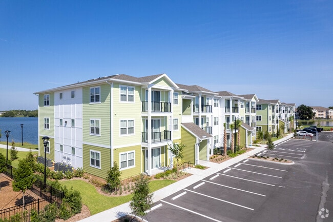
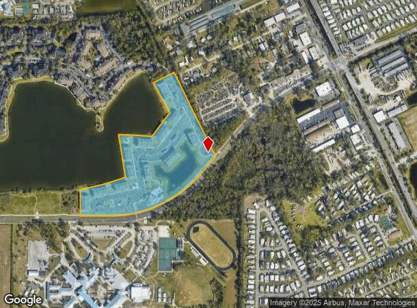
1270 Reed Canal Rd
Deltona-Daytona Beach-Ormond Beach, FL
Crystal Lake
5331-14-00-0140
LOT 14 CRYSTAL LAKE TRACT 2 MB 50 PGS 58-59 PER OR 5428 PG 1055 PER OR 5641 PG 2680 PER OR 7709 PG 0894
Multifamilydwelling
Volusia
X
Florida
12127C0369J
14
2025
19.59 AC
2026
Crystal Lake
082414
Deltona/Daytona Beach
297,722 SF
DEMOGRAPHICS near 1270 Reed Canal Rd
1 Mile
3 Mile
5 Mile
2024 Total Population
10,949
67,187
134,906
2029 Population
12,194
74,194
150,035
Pop Growth 2024-2029
+ 11.37%
+ 10.43%
+ 11.21%
Average Age
48
44
44
2024 Total Households
5,413
30,107
60,089
HH Growth 2024-2029
+ 11.73%
+ 10.88%
+ 11.68%
Median Household Inc
$47,349
$49,428
$49,993
Avg Household Size
2.00
2.10
2.10
2024 Avg HH Vehicles
2.00
2.00
2.00
Median Home Value
$113,071
$195,446
$223,728
Median Year Built
1986
1983
1982
Nearby Places
Map Layers
Map Styles
 Street
 Aerial
- Restaurants
- Banks
- Shops
- Fitness
- Groceries
PUBLIC TRANSPORTATION
AIRPORT
Daytona Beach International
DRIVE
WALK
Distance
Daytona Beach International
10 min
4.8 mi
Orlando Sanford International
DRIVE
WALK
Distance
Orlando Sanford International
57 min
39.4 mi
Freight Ports
Port Canaveral
DRIVE
WALK
Distance
Port Canaveral
81 min
68.0 mi
Nearby Properties
Address
Land Use
TOTAL SIZE
Lot Size
Zoning
Address
Land Use
TOTAL SIZE
Lot Size
Zoning
1,842,969 SF
25.56 AC
Address
Land Use
TOTAL SIZE
Lot Size
Zoning
442,125 SF
0.98 AC
A21
Address
Land Use
TOTAL SIZE
Lot Size
Zoning
490,775 SF
34.26 AC
01MH1
Address
Land Use
TOTAL SIZE
Lot Size
Zoning
396,385 SF
10 AC
01A2
Address
Land Use
TOTAL SIZE
Lot Size
Zoning
448,867 SF
5.54 AC
Address
Land Use
TOTAL SIZE
Lot Size
Zoning
13,965 SF
0.70 AC
MH1
Address
Land Use
TOTAL SIZE
Lot Size
Zoning
408,078 SF
50.07 AC
Address
Land Use
TOTAL SIZE
Lot Size
Zoning
325,744 SF
12.23 AC
Address
Land Use
TOTAL SIZE
Lot Size
Zoning
300,516 SF
70 AC
A2
Address
Land Use
TOTAL SIZE
Lot Size
Zoning
226,459 SF
0.57 AC
Address
Land Use
TOTAL SIZE
Lot Size
Zoning
379,591 SF
21.62 AC
MH1
Address
Land Use
TOTAL SIZE
Lot Size
Zoning
306,467 SF
20.76 AC
Address
Land Use
TOTAL SIZE
Lot Size
Zoning
10,360 SF
1.56 AC
Address
Land Use
TOTAL SIZE
Lot Size
Zoning
12,871 SF
0.20 AC
R4
Address
Land Use
TOTAL SIZE
Lot Size
Zoning
5,774 SF
0.94 AC
B4
Address
Land Use
TOTAL SIZE
Lot Size
Zoning
150,197 SF
16.07 AC
Address
Land Use
TOTAL SIZE
Lot Size
Zoning
94,338 SF
7.39 AC
Address
Land Use
TOTAL SIZE
Lot Size
Zoning
412,064 SF
60 AC
Address
Land Use
TOTAL SIZE
Lot Size
Zoning
184,242 SF
14.43 AC
Address
Land Use
TOTAL SIZE
Lot Size
Zoning
324,364 SF
11.59 AC
02RPUD
Address
Land Use
TOTAL SIZE
Lot Size
Zoning
92,927 SF
14.58 AC
Address
Land Use
TOTAL SIZE
Lot Size
Zoning
185,175 SF
7.50 AC
Address
Land Use
TOTAL SIZE
Lot Size
Zoning
9,952 SF
9.30 AC
16RMH
Address
Land Use
TOTAL SIZE
Lot Size
Zoning
201,947 SF
0.23 AC
Address
Land Use
TOTAL SIZE
Lot Size
Zoning
185,278 SF
15.85 AC
Address
Land Use
TOTAL SIZE
Lot Size
Zoning
175,132 SF
5 AC
Address
Land Use
TOTAL SIZE
Lot Size
Zoning
156,994 SF
47.82 AC
16A
Address
Land Use
TOTAL SIZE
Lot Size
Zoning
155,590 SF
11.08 AC
16R3H
Address
Land Use
TOTAL SIZE
Lot Size
Zoning
146,580 SF
2.80 AC
02R3
The World's #1 Commercial Real Estate Marketplace
Connect with us
© 2026 CoStar Group
The information above has been obtained from sources believed reliable. While we do not doubt its accuracy we have not verified it and make no guarantee, warranty or representation about it. It is your responsibility to independently confirm its accuracy and completeness. Any projections, opinions, assumptions, or estimates used are for example only and do not represent the current or future performance of the property. The value of this transaction to you depends on tax and other factors which should be evaluated by your tax, financial, and legal advisors. You and your advisors should conduct a careful, independent investigation of the property to determine to your satisfaction the suitability of the property for your needs.