Property Record
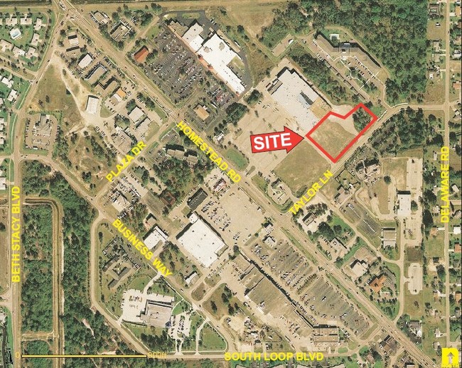
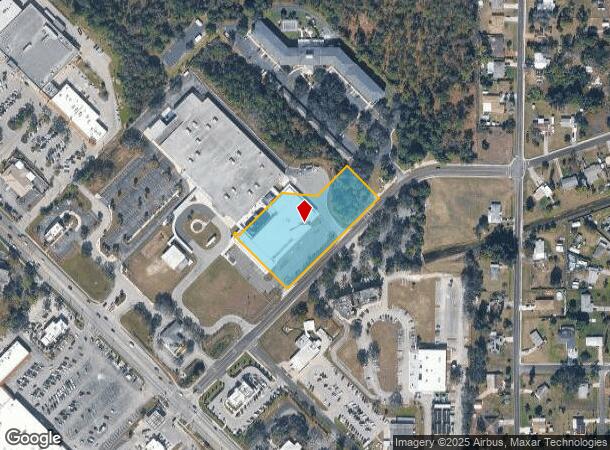
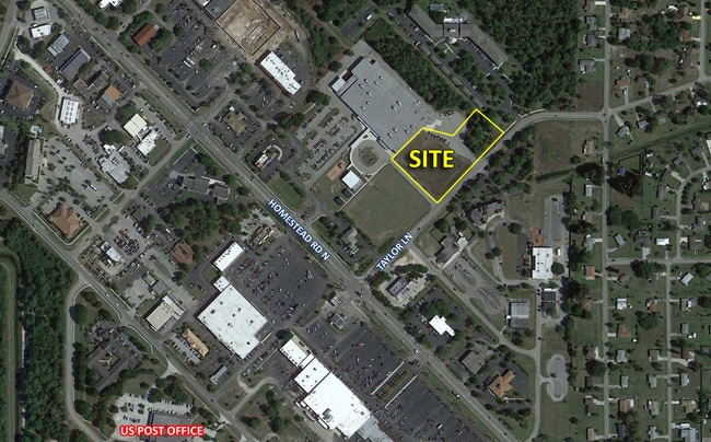
1270 Taylor Lane Ext, Lehigh Acres, FL 33936

NEARBY LISTINGS FOR SALE OR LEASE
Property Detail
1270 Taylor Lane Ext
Cape Coral-Fort Myers, FL
Lee Blvd Corridor
31-44-27-05-00001.0070
PARL IN NE1/4 AKA PT OF BLKS 3+4 SUNSHINE SHOPPING PLAZA OR2361/1632-TRACT B LESS OR 3580 PG 209 + INST#2006-213069
Publicschool
Lee
X
Florida
12071C0475F
7
0
2.20 AC
2025
Lehigh
040305
Southwest Florida
DEMOGRAPHICS near 1270 Taylor Lane Ext
1 Mile
3 Mile
5 Mile
2024 Total Population
8,219
46,021
94,889
2029 Population
9,601
54,077
111,795
Pop Growth 2024-2029
+ 16.81%
+ 17.51%
+ 17.82%
Average Age
43
38
36
2024 Total Households
3,369
15,799
30,866
HH Growth 2024-2029
+ 16.09%
+ 16.92%
+ 17.27%
Median Household Inc
$31,721
$50,624
$55,274
Avg Household Size
2.40
2.80
2.90
2024 Avg HH Vehicles
2.00
2.00
2.00
Median Home Value
$154,984
$194,999
$210,634
Median Year Built
1975
1995
2001
Nearby Places
Map Layers
Map Styles
 Street
 Aerial
- Restaurants
- Banks
- Shops
- Fitness
- Groceries
PUBLIC TRANSPORTATION
AIRPORT
Southwest Florida International
DRIVE
WALK
Distance
Southwest Florida International
23 min
11.8 mi
Punta Gorda
DRIVE
WALK
Distance
Punta Gorda
49 min
35.7 mi
SALE & LEASE HISTORY
LISTING DATE
SALE/LEASE

Apr 13, 2017
For Sale
Nearby Properties
Address
Land Use
TOTAL SIZE
Lot Size
Zoning
Address
Land Use
TOTAL SIZE
Lot Size
Zoning
187,647 SF
31.50 AC
RPD
Address
Land Use
TOTAL SIZE
Lot Size
Zoning
306,514 SF
18.98 AC
CF
Address
Land Use
TOTAL SIZE
Lot Size
Zoning
101,213 SF
11.60 AC
C-2
Address
Land Use
TOTAL SIZE
Lot Size
Zoning
145,480 SF
18.38 AC
RS-1
Address
Land Use
TOTAL SIZE
Lot Size
Zoning
127,308 SF
11.13 AC
C-2
Address
Land Use
TOTAL SIZE
Lot Size
Zoning
114,134 SF
10.67 AC
C-2
Address
Land Use
TOTAL SIZE
Lot Size
Zoning
76,346 SF
5.62 AC
CPD
Address
Land Use
TOTAL SIZE
Lot Size
Zoning
141,205 SF
33.03 AC
CF
Address
Land Use
TOTAL SIZE
Lot Size
Zoning
56,299 SF
5.57 AC
CF-2
Address
Land Use
TOTAL SIZE
Lot Size
Zoning
200,845 SF
30.04 AC
CPD
Address
Land Use
TOTAL SIZE
Lot Size
Zoning
143,777 SF
14.23 AC
RS-1
Address
Land Use
TOTAL SIZE
Lot Size
Zoning
141,740 SF
7.62 AC
CFPD
Address
Land Use
TOTAL SIZE
Lot Size
Zoning
83,611 SF
7.15 AC
C-2
Address
Land Use
TOTAL SIZE
Lot Size
Zoning
98,405 SF
15.48 AC
CS-1
Address
Land Use
TOTAL SIZE
Lot Size
Zoning
35,190 SF
2.25 AC
CPD
Address
Land Use
TOTAL SIZE
Lot Size
Zoning
3.69 AC
RM-2
Address
Land Use
TOTAL SIZE
Lot Size
Zoning
34,511 SF
2.82 AC
CPD
Address
Land Use
TOTAL SIZE
Lot Size
Zoning
67,323 SF
4.91 AC
CPD
Address
Land Use
TOTAL SIZE
Lot Size
Zoning
1,160 SF
106.33 AC
AG-2
Address
Land Use
TOTAL SIZE
Lot Size
Zoning
84,572 SF
4.17 AC
C-2
Address
Land Use
TOTAL SIZE
Lot Size
Zoning
46,885 SF
6.94 AC
CPD
Address
Land Use
TOTAL SIZE
Lot Size
Zoning
30,526 SF
6.52 AC
C-2
Address
Land Use
TOTAL SIZE
Lot Size
Zoning
34,650 SF
0.61 AC
C-1A
Address
Land Use
TOTAL SIZE
Lot Size
Zoning
88,075 SF
7.85 AC
CFPD
Address
Land Use
TOTAL SIZE
Lot Size
Zoning
250,479 SF
25.47 AC
RM-2
Address
Land Use
TOTAL SIZE
Lot Size
Zoning
31,770 SF
3.04 AC
C-2
Address
Land Use
TOTAL SIZE
Lot Size
Zoning
23,199 SF
2.76 AC
C-2
Address
Land Use
TOTAL SIZE
Lot Size
Zoning
161,390 SF
21.85 AC
RM-2
Address
Land Use
TOTAL SIZE
Lot Size
Zoning
21,646 SF
2.53 AC
C-2
Address
Land Use
TOTAL SIZE
Lot Size
Zoning
41,564 SF
3.91 AC
CG
The World's #1 Commercial Real Estate Marketplace
Connect with us
© 2026 CoStar Group
The information above has been obtained from sources believed reliable. While we do not doubt its accuracy we have not verified it and make no guarantee, warranty or representation about it. It is your responsibility to independently confirm its accuracy and completeness. Any projections, opinions, assumptions, or estimates used are for example only and do not represent the current or future performance of the property. The value of this transaction to you depends on tax and other factors which should be evaluated by your tax, financial, and legal advisors. You and your advisors should conduct a careful, independent investigation of the property to determine to your satisfaction the suitability of the property for your needs.