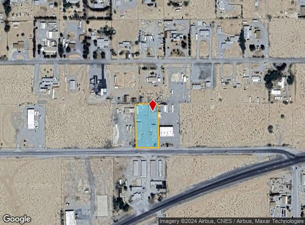
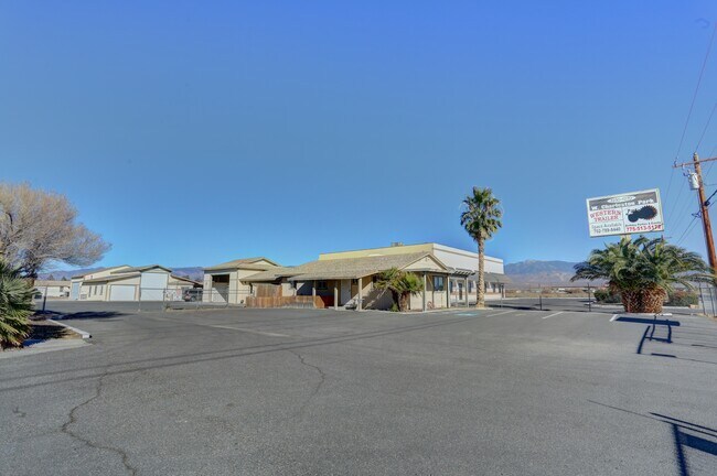
Property Record
1270 W Charleston Park Ave, Pahrump, NV 89048

NEARBY LISTINGS FOR SALE OR LEASE
Property Detail
1270 W Charleston Park Ave
Pahrump, NV
Cal Vegas Ranchos U.F
36-323-22
T20S R53E S17 U.F P.478 CAL VEGAS RANCHOS
Commercialnec
Nye
X
Nevada
32023C8825F
478
2024
0.85 AC
2025
Carson City/Nevada Area
960414
Other Market Areas
3,119 SF
DEMOGRAPHICS near 1270 W Charleston Park Ave
1 Mile
3 Mile
5 Mile
2024 Total Population
2,055
17,185
28,574
2029 Population
2,407
20,015
33,197
Pop Growth 2024-2029
+ 17.13%
+ 16.47%
+ 16.18%
Average Age
50
49
49
2024 Total Households
900
7,515
12,046
HH Growth 2024-2029
+ 17.11%
+ 16.57%
+ 16.37%
Median Household Inc
$38,333
$51,420
$51,917
Avg Household Size
2.30
2.30
2.30
2024 Avg HH Vehicles
2.00
2.00
2.00
Median Home Value
$178,999
$234,393
$248,842
Median Year Built
1994
1996
1996
Nearby Places
Map Layers
Map Styles
 Street
 Aerial
- Restaurants
- Banks
- Shops
- Fitness
- Groceries
SALE & LEASE HISTORY
LISTING DATE
SALE/LEASE

Oct 04, 2018
For Sale
Dec 27, 2020
For Sale
Aug 15, 2018
For Sale
Nearby Properties
Address
Land Use
TOTAL SIZE
Lot Size
Zoning
Address
Land Use
TOTAL SIZE
Lot Size
Zoning
133,185 SF
41.60 AC
CF
Address
Land Use
TOTAL SIZE
Lot Size
Zoning
63,853 SF
8.09 AC
GC
Address
Land Use
TOTAL SIZE
Lot Size
Zoning
51,128 SF
24.15 AC
M
Address
Land Use
TOTAL SIZE
Lot Size
Zoning
156,375 SF
13.60 AC
GC
Address
Land Use
TOTAL SIZE
Lot Size
Zoning
106,309 SF
12.24 AC
GC
Address
Land Use
TOTAL SIZE
Lot Size
Zoning
62,279 SF
7.09 AC
GC
Address
Land Use
TOTAL SIZE
Lot Size
Zoning
56,409 SF
5.44 AC
GC
Address
Land Use
TOTAL SIZE
Lot Size
Zoning
6.91 AC
LI
Address
Land Use
TOTAL SIZE
Lot Size
Zoning
10 SF
2.14 AC
OS
Address
Land Use
TOTAL SIZE
Lot Size
Zoning
12,000 SF
9.54 AC
CF
Address
Land Use
TOTAL SIZE
Lot Size
Zoning
38,606 SF
10 AC
CF
Address
Land Use
TOTAL SIZE
Lot Size
Zoning
16,466 SF
2.15 AC
GC
Address
Land Use
TOTAL SIZE
Lot Size
Zoning
20,053 SF
4.61 AC
CF
Address
Land Use
TOTAL SIZE
Lot Size
Zoning
10,282 SF
34.27 AC
OS
Address
Land Use
TOTAL SIZE
Lot Size
Zoning
13,885 SF
2.01 AC
M
Address
Land Use
TOTAL SIZE
Lot Size
Zoning
18,746 SF
5.08 AC
NC
Address
Land Use
TOTAL SIZE
Lot Size
Zoning
12,160 SF
1.26 AC
M
Address
Land Use
TOTAL SIZE
Lot Size
Zoning
25,000 SF
4.23 AC
GC
Address
Land Use
TOTAL SIZE
Lot Size
Zoning
14,027 SF
1.56 AC
GC
Address
Land Use
TOTAL SIZE
Lot Size
Zoning
12,000 SF
5 AC
CM
Address
Land Use
TOTAL SIZE
Lot Size
Zoning
24,154 SF
1.38 AC
GC
Address
Land Use
TOTAL SIZE
Lot Size
Zoning
7,656 SF
5.75 AC
CF
Address
Land Use
TOTAL SIZE
Lot Size
Zoning
9.76 AC
GC
Address
Land Use
TOTAL SIZE
Lot Size
Zoning
24,400 SF
1.10 AC
GC
Address
Land Use
TOTAL SIZE
Lot Size
Zoning
11,953 SF
3.83 AC
CF
Address
Land Use
TOTAL SIZE
Lot Size
Zoning
8,400 SF
2.17 AC
GC
Address
Land Use
TOTAL SIZE
Lot Size
Zoning
9,292 SF
1.06 AC
GC
Address
Land Use
TOTAL SIZE
Lot Size
Zoning
20,575 SF
1.63 AC
GC
Address
Land Use
TOTAL SIZE
Lot Size
Zoning
17,070 SF
2.11 AC
GC
Address
Land Use
TOTAL SIZE
Lot Size
Zoning
19,097 SF
4.25 AC
GC
The World's #1 Commercial Real Estate Marketplace
Connect with us
© 2026 CoStar Group
The information above has been obtained from sources believed reliable. While we do not doubt its accuracy we have not verified it and make no guarantee, warranty or representation about it. It is your responsibility to independently confirm its accuracy and completeness. Any projections, opinions, assumptions, or estimates used are for example only and do not represent the current or future performance of the property. The value of this transaction to you depends on tax and other factors which should be evaluated by your tax, financial, and legal advisors. You and your advisors should conduct a careful, independent investigation of the property to determine to your satisfaction the suitability of the property for your needs.