Property Record
12702 Avenue J, Lubbock, TX 79423
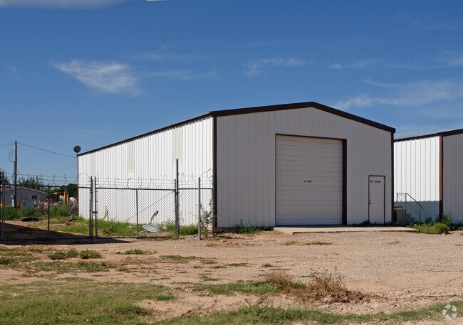

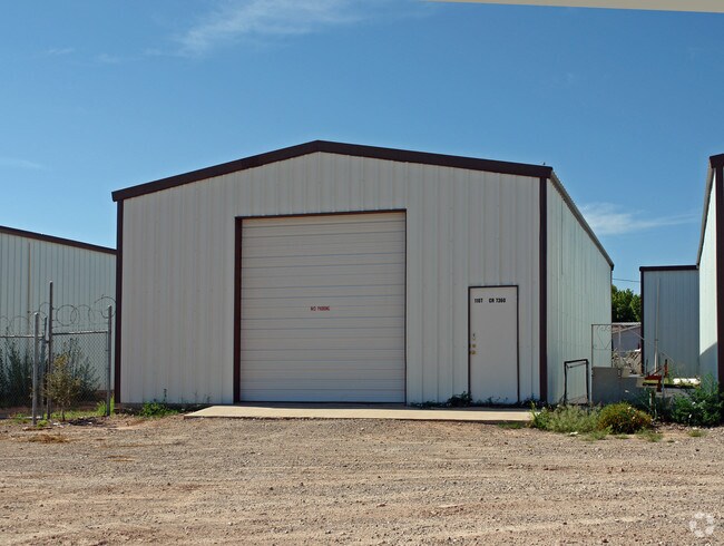

Property Detail
12702 Avenue J
Lubbock, TX
REYNOLDS SUB L 21 & N/2 OF 20
R92685
LUBBOCK
Warehouse
Texas
B and X Area of moderate flood hazard, usually the area between the limits of the 100-year and 500-year floods.
21
2024
0.90 AC
2025
Outlying Lubbock County
010512
Lubbock
15,600 SF
NEARBY LISTINGS FOR SALE OR LEASE
DEMOGRAPHICS near 12702 Avenue J
1 mile
3 mile
5 mile
2024 Total Population
3,039
28,936
83,080
2029 Population
3,338
30,924
87,379
Pop Growth 2024-2029
+ 9.84%
+ 6.87%
+ 5.17%
Average Age
34
35
37
2024 Total Households
1,063
10,727
31,790
HH Growth 2024-2029
+ 9.88%
+ 6.81%
+ 5.25%
Median Household Inc
$108,571
$86,384
$78,324
Avg Household Size
2.80
2.60
2.50
2024 Avg HH Vehicles
2.00
2.00
2.00
Median Home Value
$360,160
$250,096
$250,177
Median Year Built
2010
2007
1991
Nearby Places
Map Layers
Map Styles
 Street
 Aerial
Transit
 Traffic
 Biking
Places
Listings with unknown addresses are not visible on the map
- Restaurants
- Banks
- Shops
- Fitness
- Groceries
PUBLIC TRANSPORTATION
AIRPORT
Lubbock Preston Smith International
Drive
Walk
Distance
Lubbock Preston Smith International
30 min
18.8 mi
Nearby Properties
Address
Land Use
TOTAL SIZE
Lot Size
Zoning
Address
Land Use
TOTAL SIZE
Lot Size
Zoning
418,925 SF
37.22 AC
Address
Land Use
TOTAL SIZE
Lot Size
Zoning
187,545 SF
11.27 AC
Address
Land Use
TOTAL SIZE
Lot Size
Zoning
172,263 SF
11.01 AC
Address
Land Use
TOTAL SIZE
Lot Size
Zoning
167,208 SF
10.09 AC
Address
Land Use
TOTAL SIZE
Lot Size
Zoning
169,139 SF
12.07 AC
Address
Land Use
TOTAL SIZE
Lot Size
Zoning
157,644 SF
9.69 AC
Address
Land Use
TOTAL SIZE
Lot Size
Zoning
65,798 SF
4.11 AC
Address
Land Use
TOTAL SIZE
Lot Size
Zoning
247,475 SF
53 AC
Address
Land Use
TOTAL SIZE
Lot Size
Zoning
88,417 SF
8.01 AC
Address
Land Use
TOTAL SIZE
Lot Size
Zoning
202,036 SF
17.12 AC
Address
Land Use
TOTAL SIZE
Lot Size
Zoning
60,536 SF
7.78 AC
Address
Land Use
TOTAL SIZE
Lot Size
Zoning
205,150 SF
23.43 AC
Address
Land Use
TOTAL SIZE
Lot Size
Zoning
33,400 SF
3.03 AC
Address
Land Use
TOTAL SIZE
Lot Size
Zoning
202,299 SF
9.48 AC
Address
Land Use
TOTAL SIZE
Lot Size
Zoning
40,720 SF
6.37 AC
Address
Land Use
TOTAL SIZE
Lot Size
Zoning
112,725 SF
20 AC
Address
Land Use
TOTAL SIZE
Lot Size
Zoning
147,479 SF
7.56 AC
Address
Land Use
TOTAL SIZE
Lot Size
Zoning
30,550 SF
2.49 AC
Address
Land Use
TOTAL SIZE
Lot Size
Zoning
139,175 SF
5.80 AC
Address
Land Use
TOTAL SIZE
Lot Size
Zoning
90,560 SF
3.50 AC
Address
Land Use
TOTAL SIZE
Lot Size
Zoning
54,190 SF
10.09 AC
Address
Land Use
TOTAL SIZE
Lot Size
Zoning
12,401 SF
7.79 AC
Address
Land Use
TOTAL SIZE
Lot Size
Zoning
53,465 SF
9.90 AC
Address
Land Use
TOTAL SIZE
Lot Size
Zoning
33,263 SF
3.91 AC
Address
Land Use
TOTAL SIZE
Lot Size
Zoning
35,777 SF
3.48 AC
Address
Land Use
TOTAL SIZE
Lot Size
Zoning
9,569 SF
1.76 AC
Address
Land Use
TOTAL SIZE
Lot Size
Zoning
73,600 SF
2.29 AC
Address
Land Use
TOTAL SIZE
Lot Size
Zoning
31,000 SF
3.66 AC
Address
Land Use
TOTAL SIZE
Lot Size
Zoning
119,592 SF
5.79 AC
Address
Land Use
TOTAL SIZE
Lot Size
Zoning
94,205 SF
4.02 AC
The World's #1 Commercial Real Estate Marketplace
Connect with us
© 2026 CoStar Group
The information above has been obtained from sources believed reliable. While we do not doubt its accuracy we have not verified it and make no guarantee, warranty or representation about it. It is your responsibility to independently confirm its accuracy and completeness. Any projections, opinions, assumptions, or estimates used are for example only and do not represent the current or future performance of the property. The value of this transaction to you depends on tax and other factors which should be evaluated by your tax, financial, and legal advisors. You and your advisors should conduct a careful, independent investigation of the property to determine to your satisfaction the suitability of the property for your needs.