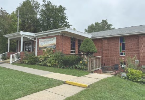
Property Record
12619 Holdridge Rd, Silver Spring, MD 20906

Property Detail
12619 Holdridge Rd
13-01195745
GLENMONT HGTS SEC 1
Religious
Montgomery
R60
Maryland
B and X Area of moderate flood hazard, usually the area between the limits of the 100-year and 500-year floods.
16
2024
0.32 AC
2025
Kensington/Wheaton
703403
Washington, DC
9,440 SF
Washington-Arlington-Alexandria, DC-VA-MD-WV
NEARBY LISTINGS FOR SALE OR LEASE
-
-
View all Silver Spring listings for sale on LoopNet.com
DEMOGRAPHICS near 12619 Holdridge Rd
1 mile
3 mile
5 mile
2024 Total Population
26,007
164,273
367,244
2029 Population
25,522
162,377
362,956
Pop Growth 2024-2029
(1.86%)
(1.15%)
(1.17%)
Average Age
38
40
41
2024 Total Households
7,390
56,309
134,914
HH Growth 2024-2029
(2.00%)
(1.18%)
(1.26%)
Median Household Inc
$91,650
$97,559
$107,816
Avg Household Size
3.30
2.80
2.60
2024 Avg HH Vehicles
2.00
2.00
2.00
Median Home Value
$389,336
$444,245
$520,380
Median Year Built
1960
1967
1969
Nearby Places
Map Layers
Map Styles
 Street
 Aerial
Transit
 Traffic
 Biking
Places
Listings with unknown addresses are not visible on the map
- Restaurants
- Banks
- Shops
- Fitness
- Groceries
PUBLIC TRANSPORTATION
TRANSIT/SUBWAY
Glenmont (Red Line - Washington Metropolitan Area Transit Authority Metrorail (Metrorail))
Drive
Walk
Distance
Glenmont (Red Line - Washington Metropolitan Area Transit Authority Metrorail (Metrorail))
2 min
9 min
0.5 mi
COMMUTER RAIL
Drive
Walk
Distance
8 min
3.5 mi
Drive
Walk
Distance
11 min
4.3 mi
AIRPORT
Ronald Reagan Washington Ntl
Drive
Walk
Distance
Ronald Reagan Washington Ntl
34 min
17.2 mi
Washington Dulles International
Drive
Walk
Distance
Washington Dulles International
49 min
28.8 mi
Baltimore/Washington International Thurgood Marshall
Drive
Walk
Distance
Baltimore/Washington International Thurgood Marshall
42 min
30.7 mi
Freight Ports
Port of Baltimore
Drive
Walk
Distance
Port of Baltimore
46 min
33.3 mi
SALE & LEASE HISTORY
LISTING DATE
SALE/LEASE

Nov 04, 2024
For Sale
Nearby Properties
Address
Land Use
TOTAL SIZE
Lot Size
Zoning
Address
Land Use
TOTAL SIZE
Lot Size
Zoning
1,332,482 SF
3.79 AC
CR2.0
Address
Land Use
TOTAL SIZE
Lot Size
Zoning
1,775,186 SF
75.19 AC
GR1.5
Address
Land Use
TOTAL SIZE
Lot Size
Zoning
515,000 SF
5.23 AC
CR1.5
Address
Land Use
TOTAL SIZE
Lot Size
Zoning
431,630 SF
25.77 AC
R60
Address
Land Use
TOTAL SIZE
Lot Size
Zoning
364,000 SF
CR6.0
Address
Land Use
TOTAL SIZE
Lot Size
Zoning
465,983 SF
1.38 AC
CR3.0
Address
Land Use
TOTAL SIZE
Lot Size
Zoning
643,335 SF
29.18 AC
R20
Address
Land Use
TOTAL SIZE
Lot Size
Zoning
429,137 SF
1.80 AC
CR4.0
Address
Land Use
TOTAL SIZE
Lot Size
Zoning
515,740 SF
19.97 AC
R20
Address
Land Use
TOTAL SIZE
Lot Size
Zoning
460,492 SF
3.56 AC
CR4.0
Address
Land Use
TOTAL SIZE
Lot Size
Zoning
152,330 SF
CR
Address
Land Use
TOTAL SIZE
Lot Size
Zoning
276,462 SF
15.11 AC
R60
Address
Land Use
TOTAL SIZE
Lot Size
Zoning
244,934 SF
3.59 AC
CRT2.
Address
Land Use
TOTAL SIZE
Lot Size
Zoning
258,000 SF
6.34 AC
PRC
Address
Land Use
TOTAL SIZE
Lot Size
Zoning
164,307 SF
16.45 AC
R90
Address
Land Use
TOTAL SIZE
Lot Size
Zoning
164,764 SF
15.42 AC
NR0.7
Address
Land Use
TOTAL SIZE
Lot Size
Zoning
540,807 SF
8.73 AC
RH
Address
Land Use
TOTAL SIZE
Lot Size
Zoning
131,521 SF
13.40 AC
PRC
Address
Land Use
TOTAL SIZE
Lot Size
Zoning
187,691 SF
3.03 AC
R90
Address
Land Use
TOTAL SIZE
Lot Size
Zoning
294,082 SF
12.18 AC
R20
Address
Land Use
TOTAL SIZE
Lot Size
Zoning
427,500 SF
25.70 AC
R30
Address
Land Use
TOTAL SIZE
Lot Size
Zoning
352,334 SF
1.66 AC
CR4.0
Address
Land Use
TOTAL SIZE
Lot Size
Zoning
425,295 SF
15.72 AC
CRT22
Address
Land Use
TOTAL SIZE
Lot Size
Zoning
215,937 SF
2.91 AC
CR2.0
Address
Land Use
TOTAL SIZE
Lot Size
Zoning
428,220 SF
18.66 AC
CR3.0
Address
Land Use
TOTAL SIZE
Lot Size
Zoning
124,896 SF
0.37 AC
CR6.0
Address
Land Use
TOTAL SIZE
Lot Size
Zoning
321,840 SF
13.95 AC
R20
Address
Land Use
TOTAL SIZE
Lot Size
Zoning
192,407 SF
15.02 AC
CR3.0
Address
Land Use
TOTAL SIZE
Lot Size
Zoning
283,516 SF
9.18 AC
R90
Address
Land Use
TOTAL SIZE
Lot Size
Zoning
332,133 SF
28.24 AC
R90
The World's #1 Commercial Real Estate Marketplace
Connect with us
© 2026 CoStar Group
The information above has been obtained from sources believed reliable. While we do not doubt its accuracy we have not verified it and make no guarantee, warranty or representation about it. It is your responsibility to independently confirm its accuracy and completeness. Any projections, opinions, assumptions, or estimates used are for example only and do not represent the current or future performance of the property. The value of this transaction to you depends on tax and other factors which should be evaluated by your tax, financial, and legal advisors. You and your advisors should conduct a careful, independent investigation of the property to determine to your satisfaction the suitability of the property for your needs.