Property Record
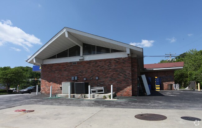
12705 Laurel Bowie Rd, Laurel, MD 20708
NEARBY LISTINGS FOR SALE OR LEASE
Property Detail
12705 Laurel Bowie Rd
10-1116003
Stanallen Estates
Storebuilding
PARCEL B (20957F COMB FR 3275476 PER OW NR REQ&SUPVR APPVL 2001)
X
Prince George's
24033C0054E
Maryland
2024
0.53 AC
2025
Laurel
800211
Washington, DC
2,219 SF
Washington-Arlington-Alexandria, DC-VA-MD-WV
DEMOGRAPHICS near 12705 Laurel Bowie Rd
1 Mile
3 Mile
5 Mile
2024 Total Population
10,232
65,079
137,784
2029 Population
10,006
64,276
136,943
Pop Growth 2024-2029
(2.21%)
(1.23%)
(0.61%)
Average Age
38
38
38
2024 Total Households
3,762
24,768
50,852
HH Growth 2024-2029
(2.31%)
(1.52%)
(0.76%)
Median Household Inc
$84,310
$81,331
$96,036
Avg Household Size
2.70
2.60
2.60
2024 Avg HH Vehicles
2.00
2.00
2.00
Median Home Value
$395,320
$379,506
$390,716
Median Year Built
1976
1983
1984
Nearby Places
Map Layers
Map Styles
 Street
 Aerial
- Restaurants
- Banks
- Shops
- Fitness
- Groceries
PUBLIC TRANSPORTATION
COMMUTER RAIL
Laurel (Camden Line - Maryland Area Regional Commuter Trains (The MARC))
DRIVE
WALK
Distance
Laurel (Camden Line - Maryland Area Regional Commuter Trains (The MARC))
7 min
3.0 mi
Muirkirk (Camden Line - Maryland Area Regional Commuter Trains (The MARC))
DRIVE
WALK
Distance
Muirkirk (Camden Line - Maryland Area Regional Commuter Trains (The MARC))
7 min
3.5 mi
AIRPORT
Baltimore/Washington International Thurgood Marshall
DRIVE
WALK
Distance
Baltimore/Washington International Thurgood Marshall
24 min
15.6 mi
Ronald Reagan Washington Ntl
DRIVE
WALK
Distance
Ronald Reagan Washington Ntl
35 min
22.1 mi
Washington Dulles International
DRIVE
WALK
Distance
Washington Dulles International
65 min
41.7 mi
Freight Ports
Port of Baltimore
DRIVE
WALK
Distance
Port of Baltimore
33 min
21.9 mi
Nearby Properties
Address
Land Use
TOTAL SIZE
Lot Size
Zoning
Address
Land Use
TOTAL SIZE
Lot Size
Zoning
393,970 SF
44 AC
RR
Address
Land Use
TOTAL SIZE
Lot Size
Zoning
399,715 SF
23.04 AC
LAUR
Address
Land Use
TOTAL SIZE
Lot Size
Zoning
791,089 SF
10.69 AC
LAUR
Address
Land Use
TOTAL SIZE
Lot Size
Zoning
657,100 SF
7.39 AC
LAUR
Address
Land Use
TOTAL SIZE
Lot Size
Zoning
514,064 SF
7.37 AC
NAC
Address
Land Use
TOTAL SIZE
Lot Size
Zoning
390,986 SF
16.87 AC
LAUR
Address
Land Use
TOTAL SIZE
Lot Size
Zoning
564,165 SF
35.85 AC
RMF12
Address
Land Use
TOTAL SIZE
Lot Size
Zoning
104,067 SF
25.29 AC
RMF20
Address
Land Use
TOTAL SIZE
Lot Size
Zoning
14.84 AC
R-15
Address
Land Use
TOTAL SIZE
Lot Size
Zoning
165,236 SF
5.24 AC
LAUR
Address
Land Use
TOTAL SIZE
Lot Size
Zoning
379,264 SF
23.08 AC
LAUR
Address
Land Use
TOTAL SIZE
Lot Size
Zoning
1,849.51 AC
ROS
Address
Land Use
TOTAL SIZE
Lot Size
Zoning
158,316 SF
20.30 AC
LAUR
Address
Land Use
TOTAL SIZE
Lot Size
Zoning
302,887 SF
24.96 AC
LAUR
Address
Land Use
TOTAL SIZE
Lot Size
Zoning
364,609 SF
8.57 AC
R22
Address
Land Use
TOTAL SIZE
Lot Size
Zoning
418,818 SF
48.07 AC
C3
Address
Land Use
TOTAL SIZE
Lot Size
Zoning
16.36 AC
RMF20
Address
Land Use
TOTAL SIZE
Lot Size
Zoning
1,495.19 AC
ROS
Address
Land Use
TOTAL SIZE
Lot Size
Zoning
15.70 AC
RMF20
Address
Land Use
TOTAL SIZE
Lot Size
Zoning
182,199 SF
43.70 AC
IE
Address
Land Use
TOTAL SIZE
Lot Size
Zoning
11.20 AC
RMF20
Address
Land Use
TOTAL SIZE
Lot Size
Zoning
10.52 AC
RMF20
Address
Land Use
TOTAL SIZE
Lot Size
Zoning
63,896 SF
229.19 AC
W1B
Address
Land Use
TOTAL SIZE
Lot Size
Zoning
9.14 AC
LAUR
Address
Land Use
TOTAL SIZE
Lot Size
Zoning
37,872 SF
10.29 AC
RMF20
Address
Land Use
TOTAL SIZE
Lot Size
Zoning
253,396 SF
5.96 AC
LAUR
Address
Land Use
TOTAL SIZE
Lot Size
Zoning
142,372 SF
13.88 AC
LAUR
Address
Land Use
TOTAL SIZE
Lot Size
Zoning
766.09 AC
ROS
Address
Land Use
TOTAL SIZE
Lot Size
Zoning
16,465 SF
3.52 AC
CACLI
Address
Land Use
TOTAL SIZE
Lot Size
Zoning
11.11 AC
R15
The World's #1 Commercial Real Estate Marketplace
Connect with us
© 2026 CoStar Group
The information above has been obtained from sources believed reliable. While we do not doubt its accuracy we have not verified it and make no guarantee, warranty or representation about it. It is your responsibility to independently confirm its accuracy and completeness. Any projections, opinions, assumptions, or estimates used are for example only and do not represent the current or future performance of the property. The value of this transaction to you depends on tax and other factors which should be evaluated by your tax, financial, and legal advisors. You and your advisors should conduct a careful, independent investigation of the property to determine to your satisfaction the suitability of the property for your needs.