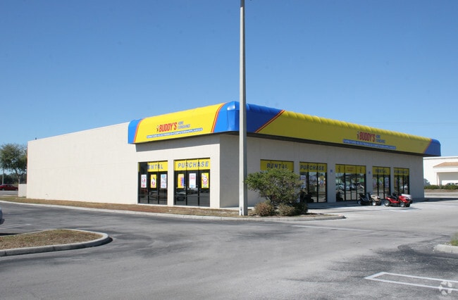
Property Record
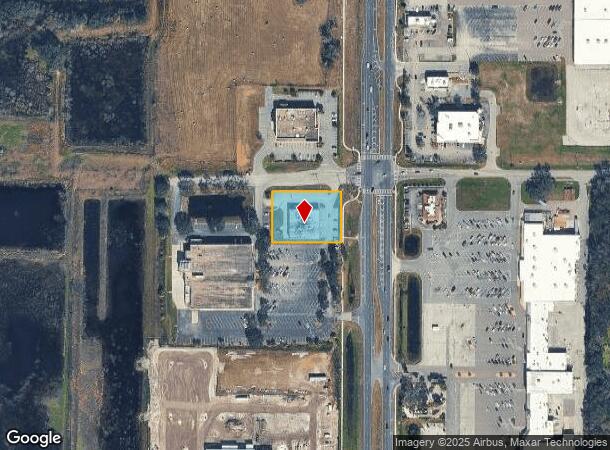
12709 Us Highway 301, Dade City, FL 33525

Current Lease Availabilities
NEARBY LISTINGS FOR SALE OR LEASE
Property Detail
12709 Us Highway 301
Tampa-St. Petersburg-Clearwater, FL
Acreage
03-25-21-0000-00100-0020
COM AT RR SPIKE AT NE COR OF SOUTH1/2 OF NE1/4 OF SEC 3 TH S88DEG 4647W 100.40 FT ALG NORTH LINE OF SOUTH1/2 OF NE1/4 OF SEC 3 TO POINT OF INTERSECTION WITH WLY R/W LINE OF US HWY 301 TH S00DEG 48 16E 30 FT ALG SAID WLY LINE FOR POB TH CONT S00DEG 48
Storebuilding
Pasco
X
Florida
12101C0280F
2
2024
0.96 AC
2025
Pasco County
032602
Tampa/St Petersburg
10,000 SF
DEMOGRAPHICS near 12709 Us Highway 301
1 Mile
3 Mile
5 Mile
2024 Total Population
3,224
21,327
32,817
2029 Population
3,913
25,892
39,606
Pop Growth 2024-2029
+ 21.37%
+ 21.40%
+ 20.69%
Average Age
43
41
42
2024 Total Households
1,229
8,045
12,209
HH Growth 2024-2029
+ 21.16%
+ 21.33%
+ 21.08%
Median Household Inc
$59,122
$55,454
$57,388
Avg Household Size
2.50
2.50
2.50
2024 Avg HH Vehicles
2.00
2.00
2.00
Median Home Value
$213,115
$182,383
$206,635
Median Year Built
1983
1983
1987
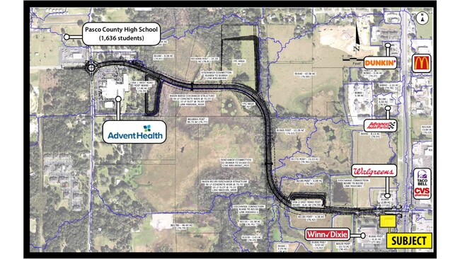
Nearby Places
- Restaurants
- Banks
- Shops
- Fitness
- Groceries
PUBLIC TRANSPORTATION
AIRPORT
Tampa International
DRIVE
WALK
Distance
Tampa International
64 min
45.1 mi
Nearby Properties
Address
Land Use
TOTAL SIZE
Lot Size
Zoning
Address
Land Use
TOTAL SIZE
Lot Size
Zoning
203,039 SF
41.45 AC
MF1
Address
Land Use
TOTAL SIZE
Lot Size
Zoning
127,340 SF
15.04 AC
AC
Address
Land Use
TOTAL SIZE
Lot Size
Zoning
191,025 SF
27.54 AC
RIO
Address
Land Use
TOTAL SIZE
Lot Size
Zoning
119,784 SF
7.79 AC
RIO
Address
Land Use
TOTAL SIZE
Lot Size
Zoning
80,036 SF
12 AC
C2
Address
Land Use
TOTAL SIZE
Lot Size
Zoning
98,666 SF
19.80 AC
RIO
Address
Land Use
TOTAL SIZE
Lot Size
Zoning
320,071 SF
23.74 AC
PDEC
Address
Land Use
TOTAL SIZE
Lot Size
Zoning
82,689 SF
19.18 AC
RG1
Address
Land Use
TOTAL SIZE
Lot Size
Zoning
76,418 SF
2.78 AC
RIO
Address
Land Use
TOTAL SIZE
Lot Size
Zoning
84,706 SF
13.65 AC
RIO
Address
Land Use
TOTAL SIZE
Lot Size
Zoning
54,371 SF
8.09 AC
CH
Address
Land Use
TOTAL SIZE
Lot Size
Zoning
111,677 SF
10.40 AC
CG
Address
Land Use
TOTAL SIZE
Lot Size
Zoning
16,994 SF
2.40 AC
CG
Address
Land Use
TOTAL SIZE
Lot Size
Zoning
33,580 SF
6.09 AC
RIO
Address
Land Use
TOTAL SIZE
Lot Size
Zoning
88,358 SF
36.68 AC
OUA
Address
Land Use
TOTAL SIZE
Lot Size
Zoning
86,138 SF
6.62 AC
CG
Address
Land Use
TOTAL SIZE
Lot Size
Zoning
37,368 SF
10.82 AC
CG
Address
Land Use
TOTAL SIZE
Lot Size
Zoning
76,818 SF
15 AC
AC
Address
Land Use
TOTAL SIZE
Lot Size
Zoning
64,520 SF
11.65 AC
I2
Address
Land Use
TOTAL SIZE
Lot Size
Zoning
65,354 SF
15 AC
RIO
Address
Land Use
TOTAL SIZE
Lot Size
Zoning
26,520 SF
4.42 AC
CG
Address
Land Use
TOTAL SIZE
Lot Size
Zoning
95,673 SF
7.51 AC
PDH2
Address
Land Use
TOTAL SIZE
Lot Size
Zoning
36,518 SF
2.77 AC
CG
Address
Land Use
TOTAL SIZE
Lot Size
Zoning
131,580 SF
3.84 AC
PDEC
Address
Land Use
TOTAL SIZE
Lot Size
Zoning
44,210 SF
7.10 AC
C2
Address
Land Use
TOTAL SIZE
Lot Size
Zoning
32,530 SF
33 AC
RIO
Address
Land Use
TOTAL SIZE
Lot Size
Zoning
35,904 SF
5.19 AC
RS1
Address
Land Use
TOTAL SIZE
Lot Size
Zoning
130,200 SF
0.74 AC
CBD
Address
Land Use
TOTAL SIZE
Lot Size
Zoning
112,952 SF
13.03 AC
MF1
Address
Land Use
TOTAL SIZE
Lot Size
Zoning
41,400 SF
4.91 AC
PDEC
The World's #1 Commercial Real Estate Marketplace
Connect with us
© 2025 CoStar Group
The information above has been obtained from sources believed reliable. While we do not doubt its accuracy we have not verified it and make no guarantee, warranty or representation about it. It is your responsibility to independently confirm its accuracy and completeness. Any projections, opinions, assumptions, or estimates used are for example only and do not represent the current or future performance of the property. The value of this transaction to you depends on tax and other factors which should be evaluated by your tax, financial, and legal advisors. You and your advisors should conduct a careful, independent investigation of the property to determine to your satisfaction the suitability of the property for your needs.