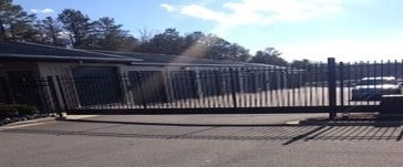
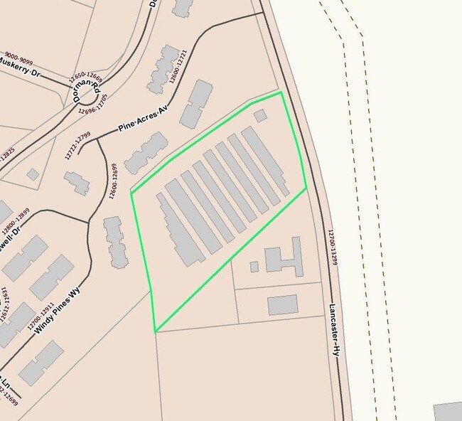
Property Record
12710 Lancaster Hwy, Pineville, NC 28134
NEARBY LISTINGS FOR SALE OR LEASE
Property Detail
12710 Lancaster Hwy
221-501-06
Mecklenburg
Publicstorage
North Carolina
X
6
45057C0009E
6.23 AC
0
South/485
2025
Charlotte
005867
Charlotte-Concord-Gastonia, NC-SC
80,380 SF
DEMOGRAPHICS near 12710 Lancaster Hwy
1 Mile
3 Mile
5 Mile
2024 Total Population
7,106
71,488
171,547
2029 Population
7,444
76,854
185,138
Pop Growth 2024-2029
+ 4.76%
+ 7.51%
+ 7.92%
Average Age
39
38
39
2024 Total Households
3,012
28,865
68,252
HH Growth 2024-2029
+ 4.78%
+ 7.36%
+ 7.80%
Median Household Inc
$59,796
$87,503
$96,066
Avg Household Size
2.30
2.40
2.50
2024 Avg HH Vehicles
1.00
2.00
2.00
Median Home Value
$263,109
$361,330
$400,569
Median Year Built
1996
1996
1996
Nearby Places
Map Layers
Map Styles
 Street
 Aerial
- Restaurants
- Banks
- Shops
- Fitness
- Groceries
PUBLIC TRANSPORTATION
AIRPORT
Charlotte/Douglas International
DRIVE
WALK
Distance
Charlotte/Douglas International
23 min
12.6 mi
Concord-Padgett Regional
DRIVE
WALK
Distance
Concord-Padgett Regional
44 min
35.6 mi
Freight Ports
North Charleston Terminal
DRIVE
WALK
Distance
North Charleston Terminal
219 min
191.7 mi
Nearby Properties
Address
Land Use
TOTAL SIZE
Lot Size
Zoning
Address
Land Use
TOTAL SIZE
Lot Size
Zoning
922,476 SF
49.91 AC
BP
Address
Land Use
TOTAL SIZE
Lot Size
Zoning
244,692 SF
264.29 AC
I2
Address
Land Use
TOTAL SIZE
Lot Size
Zoning
654,693 SF
51.50 AC
O1
Address
Land Use
TOTAL SIZE
Lot Size
Zoning
646,209 SF
72.24 AC
CC
Address
Land Use
TOTAL SIZE
Lot Size
Zoning
306,928 SF
53.98 AC
Address
Land Use
TOTAL SIZE
Lot Size
Zoning
720,470 SF
5.45 AC
Address
Land Use
TOTAL SIZE
Lot Size
Zoning
430,352 SF
40.09 AC
R12MFCD
Address
Land Use
TOTAL SIZE
Lot Size
Zoning
425,591 SF
31.58 AC
MX1
Address
Land Use
TOTAL SIZE
Lot Size
Zoning
361,910 SF
3.60 AC
Address
Land Use
TOTAL SIZE
Lot Size
Zoning
465,462 SF
23.76 AC
CC
Address
Land Use
TOTAL SIZE
Lot Size
Zoning
326,013 SF
25.59 AC
RMF
Address
Land Use
TOTAL SIZE
Lot Size
Zoning
305,449 SF
17.90 AC
R17MFCD
Address
Land Use
TOTAL SIZE
Lot Size
Zoning
539,429 SF
5.37 AC
Address
Land Use
TOTAL SIZE
Lot Size
Zoning
480,041 SF
4.76 AC
Address
Land Use
TOTAL SIZE
Lot Size
Zoning
294,279 SF
27.77 AC
R12MFCD
Address
Land Use
TOTAL SIZE
Lot Size
Zoning
215,600 SF
6.97 AC
R3
Address
Land Use
TOTAL SIZE
Lot Size
Zoning
3,183 SF
3.82 AC
Address
Land Use
TOTAL SIZE
Lot Size
Zoning
698,101 SF
5 AC
Address
Land Use
TOTAL SIZE
Lot Size
Zoning
348,409 SF
26.08 AC
R17MFCD
Address
Land Use
TOTAL SIZE
Lot Size
Zoning
357,068 SF
28.04 AC
R15MFCD
Address
Land Use
TOTAL SIZE
Lot Size
Zoning
321,129 SF
23.59 AC
MX2
Address
Land Use
TOTAL SIZE
Lot Size
Zoning
452,964 SF
9.19 AC
OCCD
Address
Land Use
TOTAL SIZE
Lot Size
Zoning
324,998 SF
16.60 AC
OICD
Address
Land Use
TOTAL SIZE
Lot Size
Zoning
279,674 SF
18.28 AC
CC
Address
Land Use
TOTAL SIZE
Lot Size
Zoning
518,080 SF
5.44 AC
Address
Land Use
TOTAL SIZE
Lot Size
Zoning
364,274 SF
3.50 AC
CC
Address
Land Use
TOTAL SIZE
Lot Size
Zoning
293,128 SF
22.70 AC
MX2
Address
Land Use
TOTAL SIZE
Lot Size
Zoning
497,462 SF
5.64 AC
BPCD
Address
Land Use
TOTAL SIZE
Lot Size
Zoning
497,462 SF
6.32 AC
BPCD
Address
Land Use
TOTAL SIZE
Lot Size
Zoning
429,918 SF
13.50 AC
O1
The World's #1 Commercial Real Estate Marketplace
Connect with us
© 2026 CoStar Group
The information above has been obtained from sources believed reliable. While we do not doubt its accuracy we have not verified it and make no guarantee, warranty or representation about it. It is your responsibility to independently confirm its accuracy and completeness. Any projections, opinions, assumptions, or estimates used are for example only and do not represent the current or future performance of the property. The value of this transaction to you depends on tax and other factors which should be evaluated by your tax, financial, and legal advisors. You and your advisors should conduct a careful, independent investigation of the property to determine to your satisfaction the suitability of the property for your needs.