Property Record
12715 Philips Hwy, Jacksonville, FL 32256
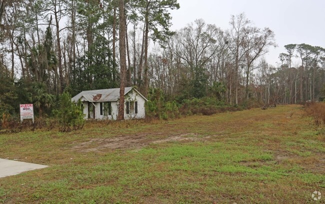


This Property Is For Sale
NEARBY LISTINGS FOR SALE OR LEASE
Property Detail
12715 Philips Hwy
Jacksonville, FL
Bayard
167934-1000
Duval
Sfr
Florida
X
1.53 AC
12031C0569H
Butler/Baymeadows
512 SF
Jacksonville (Florida)
DEMOGRAPHICS near 12715 Philips Hwy
1 Mile
3 Mile
5 Mile
2024 Total Population
5,895
35,722
94,796
2029 Population
6,412
38,914
109,016
Pop Growth 2024-2029
+ 8.77%
+ 8.94%
+ 15.00%
Average Age
36
37
38
2024 Total Households
2,384
14,315
35,332
HH Growth 2024-2029
+ 8.93%
+ 8.44%
+ 13.63%
Median Household Inc
$81,586
$96,485
$101,847
Avg Household Size
2.40
2.40
2.60
2024 Avg HH Vehicles
2.00
2.00
2.00
Median Home Value
$284,673
$324,508
$355,776
Median Year Built
2010
2010
2008
Nearby Places
Map Layers
Map Styles
 Street
 Aerial
- Restaurants
- Banks
- Shops
- Fitness
- Groceries
PUBLIC TRANSPORTATION
AIRPORT
Jacksonville International
DRIVE
WALK
Distance
Jacksonville International
42 min
32.0 mi
Freight Ports
Jacksonville Port
DRIVE
WALK
Distance
Jacksonville Port
29 min
19.6 mi
Nearby Properties
Address
Land Use
TOTAL SIZE
Lot Size
Zoning
Address
Land Use
TOTAL SIZE
Lot Size
Zoning
879,352 SF
31.37 AC
PUD
Address
Land Use
TOTAL SIZE
Lot Size
Zoning
534,591 SF
39.81 AC
PUD
Address
Land Use
TOTAL SIZE
Lot Size
Zoning
470,627 SF
21.61 AC
PUD
Address
Land Use
TOTAL SIZE
Lot Size
Zoning
450,888 SF
27.01 AC
PUD
Address
Land Use
TOTAL SIZE
Lot Size
Zoning
381,269 SF
25.73 AC
PUD
Address
Land Use
TOTAL SIZE
Lot Size
Zoning
243,751 SF
15.29 AC
PUD
Address
Land Use
TOTAL SIZE
Lot Size
Zoning
262,781 SF
11.40 AC
PUD
Address
Land Use
TOTAL SIZE
Lot Size
Zoning
250,708 SF
13.52 AC
PUD
Address
Land Use
TOTAL SIZE
Lot Size
Zoning
340,852 SF
19.65 AC
PUD
Address
Land Use
TOTAL SIZE
Lot Size
Zoning
311,304 SF
18.93 AC
PUD
Address
Land Use
TOTAL SIZE
Lot Size
Zoning
298,018 SF
15.53 AC
PUD
Address
Land Use
TOTAL SIZE
Lot Size
Zoning
215,194 SF
58.34 AC
PUD
Address
Land Use
TOTAL SIZE
Lot Size
Zoning
212,510 SF
19.07 AC
CRO
Address
Land Use
TOTAL SIZE
Lot Size
Zoning
241,882 SF
10.83 AC
PUD
Address
Land Use
TOTAL SIZE
Lot Size
Zoning
427,236 SF
69.60 AC
PUD
Address
Land Use
TOTAL SIZE
Lot Size
Zoning
271,074 SF
17.77 AC
CCG-1
Address
Land Use
TOTAL SIZE
Lot Size
Zoning
276,262 SF
10.01 AC
PUD
Address
Land Use
TOTAL SIZE
Lot Size
Zoning
264,962 SF
11.24 AC
PUD
Address
Land Use
TOTAL SIZE
Lot Size
Zoning
262,043 SF
10.89 AC
PUD
Address
Land Use
TOTAL SIZE
Lot Size
Zoning
158,114 SF
5.73 AC
PUD
Address
Land Use
TOTAL SIZE
Lot Size
Zoning
289,228 SF
38.96 AC
Address
Land Use
TOTAL SIZE
Lot Size
Zoning
159,391 SF
36.52 AC
PUD
Address
Land Use
TOTAL SIZE
Lot Size
Zoning
356,254 SF
22.04 AC
PUD
Address
Land Use
TOTAL SIZE
Lot Size
Zoning
215,287 SF
29.59 AC
PUD
Address
Land Use
TOTAL SIZE
Lot Size
Zoning
171,277 SF
7.36 AC
PUD
Address
Land Use
TOTAL SIZE
Lot Size
Zoning
119,560 SF
22.05 AC
PUD
Address
Land Use
TOTAL SIZE
Lot Size
Zoning
230,730 SF
42.22 AC
PBF-2
Address
Land Use
TOTAL SIZE
Lot Size
Zoning
174,103 SF
7.56 AC
PUD
Address
Land Use
TOTAL SIZE
Lot Size
Zoning
354,503 SF
22.37 AC
PUD
Address
Land Use
TOTAL SIZE
Lot Size
Zoning
78,903 SF
22.19 AC
The World's #1 Commercial Real Estate Marketplace
Connect with us
© 2025 CoStar Group
The information above has been obtained from sources believed reliable. While we do not doubt its accuracy we have not verified it and make no guarantee, warranty or representation about it. It is your responsibility to independently confirm its accuracy and completeness. Any projections, opinions, assumptions, or estimates used are for example only and do not represent the current or future performance of the property. The value of this transaction to you depends on tax and other factors which should be evaluated by your tax, financial, and legal advisors. You and your advisors should conduct a careful, independent investigation of the property to determine to your satisfaction the suitability of the property for your needs.